

VerkehrszeichenSchweiz
 Verkehrsregeln
 Schweiz
51. Kreuzungsverlauf
Ein Kreuzungsverlauf ist eine schematische Darstellung des Aufbaus einer bevorstehenden Kreuzung oder Einmündung. Er kann zeigen, wie Straßen abzweigen, sich kreuzen oder weiterführen, und hilft Fahrern, schon vor Erreichen der Kreuzung die richtige Richtung zu erkennen.
Solche schematischen Darstellungen werden häufig auf Vorwegweisern verwendet. Je nach Zeichensystem des Landes kann das Diagramm außerdem Haupt- und Nebenstraßen, Straßennummern oder Ziele unterscheiden.
What is a crossroad shape?
A crossroad shape is a simplified diagram showing the physical arrangement and directions of roads at an upcoming intersection.
Why is the shape of an intersection shown on a road sign?
It helps drivers understand the junction layout in advance and choose the correct direction before reaching the intersection.
Does a crossroad-shape diagram always show every physical detail?
No. These diagrams are normally simplified and may omit features such as traffic islands, medians or other minor road details so that the important directions remain easy to understand.

52. Führerschein
Ein Führerschein ist ein amtliches Dokument, das eine Person zum Führen einer oder mehrerer bestimmter Kategorien von Kraftfahrzeugen berechtigt. Er kann Bedingungen, Beschränkungen, Klassencodes und Ablaufdaten enthalten, die bestimmen, welche Fahrzeuge der Inhaber führen darf.
Fahrer müssen einen Führerschein besitzen, der für die betreffende Fahrzeugkategorie und den jeweiligen Rechtsraum gültig ist. Eine Fahrerlaubnis kann vorläufig, vollständig, beschränkt, ausgesetzt oder entzogen sein; für gewerbliches Fahren können zusätzliche Qualifikationen erforderlich sein.
What is a driving licence?
A driving licence is an official authorisation to drive specified categories of motor vehicle.
Is a driving licence the same as a driving permit?
The terms may refer to the same document, depending on the country. Some countries use permit specifically for learners or temporary authorisations.
What is a provisional driving licence?
A provisional or learner licence allows a person to practise driving under specified restrictions before obtaining a full licence.
What is a full driving licence?
A full licence is issued after the holder has completed the required tests or training. Restrictions may still apply because of age, vehicle type, medical fitness or licence codes.
Does one licence allow you to drive every vehicle?
No. Driving licences are divided into categories for motorcycles, cars, buses, trucks, trailers and other vehicles.
What is a licence category?
A licence category identifies the type and size of vehicle the holder is authorised to drive.
Must the licence be valid for the vehicle being driven?
Yes. Holding a licence for one category does not normally authorise driving a vehicle belonging to another category.
Can a licence contain restrictions?
Yes. Codes may restrict the holder to an automatic transmission, corrective lenses, an adapted vehicle or another specified condition.
What is the difference between an automatic and manual licence?
In some countries, passing the test in an automatic vehicle restricts the holder to automatic vehicles until an additional test or procedure is completed.
Does a driving licence expire?
Usually, yes. The document, individual categories or medical authorisation may have expiry dates and require renewal.
May you drive with an expired licence?
No. The licence and the category required for the vehicle must remain valid.
Must you carry your driving licence?
This depends on local law. Many countries require drivers to carry the original licence and present it to an authorised officer when requested.
Is a photograph or copy of the licence sufficient?
Not normally. A photograph, scan or photocopy is not generally a substitute for the original document unless an official digital-licence system is legally recognised.
Does a driving licence prove that you own the vehicle?
No. It proves driving authorisation, not ownership, registration or insurance.
What tests are required to obtain a licence?
Requirements may include a theory test, eyesight test, practical driving test, medical examination or compulsory training.
Is there a universal minimum driving age?
No. Minimum ages differ between countries and vehicle categories.
Can a learner drive without supervision?
Only where the provisional-licence system permits independent driving. Other learners must be accompanied by an approved supervisor or instructor.
Can a learner drive in another country?
Often not. Provisional and learner licences are frequently valid only in the country or region that issued them.
What is an international driving permit?
An international driving permit is a standardised translation of a valid national licence intended to help authorities interpret it abroad.
Does an international driving permit replace a national licence?
No. It normally has legal value only when presented together with the valid national driving licence on which it is based.
Is a national licence valid abroad?
This depends on the destination, length of stay, residence status and agreements between the countries concerned. An exchange or international permit may be required.
Can a foreign licence be exchanged?
Some countries exchange recognised foreign licences without new tests, while others require theory, practical or medical examinations.
Can medical fitness affect a licence?
Yes. A medical condition may require an assessment, shorter validity period, adapted vehicle or licence restriction.
Must changes in medical fitness be reported?
This depends on local law. Drivers remain responsible for ensuring that they are physically and mentally fit to drive safely.
Do professional drivers need additional qualifications?
Often, yes. Drivers of trucks, buses, taxis or vehicles used commercially may require professional competence, medical examinations or periodic training.
What happens when a licence is suspended?
The holder may not drive during the suspension period, even if the physical document remains in their possession.
What is disqualification from driving?
Disqualification is a legal prohibition on driving, usually imposed by a court or competent authority for a specified period or until conditions are fulfilled.
What should you do if the licence is lost or stolen?
Report it where required and apply for a replacement through the competent licensing authority. Do not continue driving when local law requires the original document to be carried.
What should you do if the licence is damaged?
Request a replacement when the document is unreadable, damaged or no longer allows the holder to be identified reliably.
Does changing address require a new licence?
This depends on the country and whether the address appears on the licence. Drivers must follow the local notification and replacement procedure.
53. Kilometrierungsmarkierung
Eine Kilometrierungsmarkierung ist eine Referenz am Straßenrand, die eine gemessene Position entlang einer Straße angibt. Sie kennzeichnet normalerweise einen Kilometer, eine Meile oder einen kleineren Abschnitt, gemessen von einem festgelegten Ausgangspunkt der Route.
Kilometer- und Hektometermarkierungen helfen Verkehrsteilnehmern, Rettungsdiensten, Straßenbehörden und Wartungsteams, einen genauen Straßenabschnitt zu bestimmen. Sie legen weder Geschwindigkeitsbegrenzungen noch Vorfahrt oder Zufahrtsbeschränkungen fest.
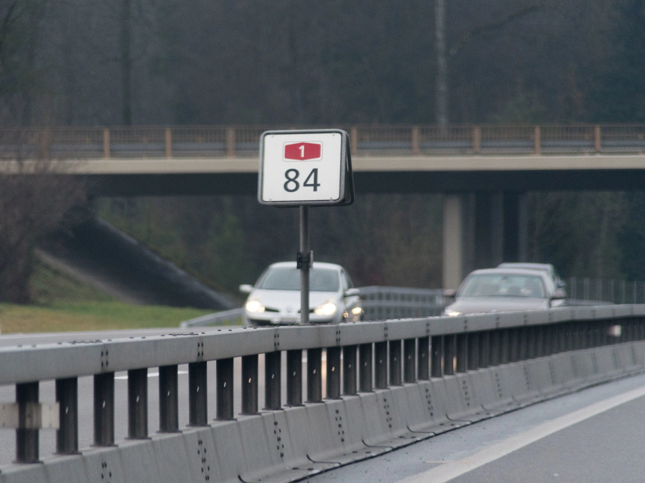
What is a road location marker?
A road location marker is a numbered reference point identifying a measured position along a particular road or route.
What is a kilometre marker?
A kilometre marker indicates the number of kilometres measured from an established starting point on the road.
What is a hectometre marker?
A hectometre marker identifies a position at intervals of 100 metres. One kilometre contains ten hectometres.
What does a marker showing 14.7 mean?
It normally identifies a point approximately 14 kilometres and 700 metres from the route’s reference origin.
Is the marker the distance to the next town?
No. It normally measures the position along the road from a fixed reference origin rather than the remaining distance to a destination.
Where does the kilometre measurement begin?
It begins at a reference point chosen for that road, such as the start of the route, a border, an administrative boundary or another officially defined origin.
Does the numbering always increase in the direction of travel?
No. It increases in the officially defined direction of the route. Drivers travelling in the opposite direction may see the values decrease.
How can you recognise a location marker?
It may appear as a numbered roadside post, small sign, plate, marker attached to a barrier or numbers painted beside the carriageway.
Are kilometre markers used in every country?
Many countries use kilometre markers, while countries using imperial measurements may use mile markers. Designs and intervals differ.
Are hectometre markers always placed every 100 metres?
They are intended to represent 100-metre intervals, but their physical placement and permitted tolerances depend on the road authority and local conditions.
What information should you give during an emergency?
Give the road number, marker value, direction of travel and nearest junction or landmark where possible.
Why is the road number important?
The same kilometre value may occur on many different roads. The road number identifies which route the marker belongs to.
Why is the direction of travel important?
Divided roads have separate carriageways. Reporting the direction helps emergency services approach the correct side without making a long diversion.
Can a marker help locate a breakdown?
Yes. Reporting the nearest marker can help breakdown and emergency services identify the affected road section more accurately.
Can it help report debris or another hazard?
Yes. The marker can help road authorities locate an obstruction, damaged barrier, animal, collision or other dangerous situation.
Is a location marker a traffic sign?
Normally not. It is a reference or identification device rather than a regulatory sign.
Does it impose a speed limit?
No. The applicable speed comes from general traffic rules and regulatory speed signs.
Does it change priority?
No. Traffic lights, priority signs and ordinary intersection rules remain applicable.
Does it mark the beginning of a new road rule?
No. Passing a kilometre or hectometre marker does not normally begin or end a traffic regulation.
Can markers be used for road maintenance?
Yes. Road authorities use reference points to locate signs, barriers, bridges, defects, works and other infrastructure precisely.
Can navigation coordinates replace a location marker?
Coordinates can be useful, but a road reference marker may be easier for road operators and emergency services to connect with the correct carriageway and road section.
What if the marker is damaged or missing?
Use the nearest visible marker together with the road number, direction, junctions and other identifiable features.
Should a driver stop simply to read a marker?
No. Do not stop in a live lane or another prohibited location. A passenger may note the marker, or the driver may read it after stopping somewhere safe during an actual emergency.
Can temporary roadworks change the marker values?
Normally not. Temporary traffic routes may move traffic away from the marker’s usual position, but the official road reference system generally remains unchanged.
54. Straßennummer
Eine Straßennummer ist eine Zahl oder Kombination aus Buchstaben und Zahlen, die eine bestimmte Straße oder Route innerhalb eines Straßennetzes identifiziert. Straßennummern helfen Fahrern, Routen zu verfolgen, verschiedene Straßentypen zu unterscheiden und zwischen Städten, Regionen und Ländern zu navigieren.
Straßennummern werden häufig auf Routenkennzeichen und Wegweisern angezeigt. Format, Farbe und Präfixe unterscheiden sich je nach Land und können erkennen lassen, ob es sich um eine Autobahn, Nationalstraße, Regionalstraße oder internationale Route handelt.
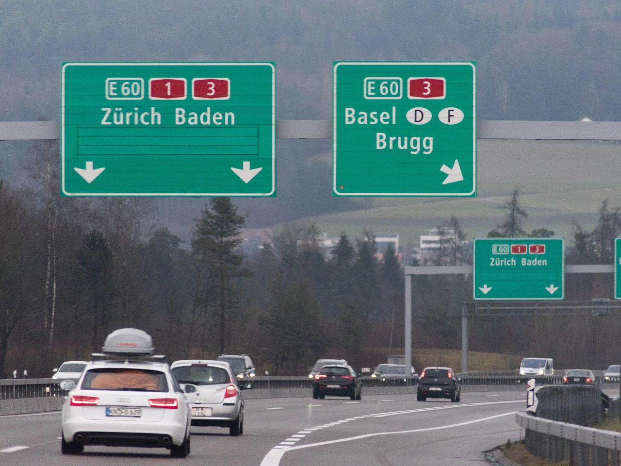
What is a road number?
A road number is an identifier assigned to a particular road or route, usually consisting of numbers alone or a combination of letters and numbers.
Where can you find road numbers?
Road numbers are commonly displayed on route markers, direction signs and advance direction signs to help drivers follow the correct route.
Do road-number systems differ between countries?
Yes. Countries use different prefixes, colours and numbering systems to distinguish motorways, national roads, regional roads and international routes.
55. Entfernungstafeln
Entfernungstafeln sind eine Folge von Straßenzeichen, die anzeigen, dass sich eine bestimmte Stelle wie eine Autobahnausfahrt, Kreuzung oder ein Bahnübergang nähert. Häufig verwenden sie eine abnehmende Anzahl von Balken oder anderen Symbolen, damit Fahrer die verbleibende Annäherung abschätzen können.
Die Tafeln stehen normalerweise in zunehmend kürzeren Abständen vor der vorausliegenden Stelle. Gestaltung, Abstände und Bedeutung unterscheiden sich je nach Land; Fahrer sollten daher nicht davon ausgehen, dass jeder Balken immer dieselbe Entfernung darstellt.
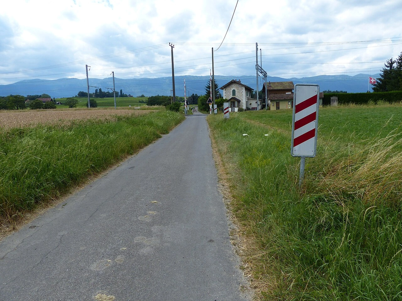
What are countdown markers?
Countdown markers are a series of signs that progressively indicate how close a driver is to an upcoming exit, junction, crossing or other important point.
What do the bars on countdown markers mean?
The number of bars normally decreases as the driver approaches the indicated location. Depending on the country, the bars may represent fixed distances or simply successive stages of the approach.
Where are countdown markers commonly used?
They are commonly associated with motorway exits, major junctions and railway crossings, although their use and design differ between countries.
56. Verkehrsspiegel
Ein Verkehrsspiegel ist ein konvexer Spiegel, der in der Nähe einer Kreuzung, Einfahrt, Kurve oder einer anderen Stelle mit eingeschränkter Sicht angebracht wird. Seine gewölbte Oberfläche bietet einen größeren Blickwinkel auf herannahende Verkehrsteilnehmer als ein flacher Spiegel.
Ein Verkehrsspiegel ist nur eine Sichthilfe. Er kann Entfernung, Geschwindigkeit und Richtung verzerren und durch Dunkelheit, Wetter, Schmutz oder Beschädigung beeinträchtigt sein. Fahrer müssen die Straße weiterhin direkt beobachten, alle Vorfahrtsregeln beachten und nur weiterfahren, wenn es sicher ist.
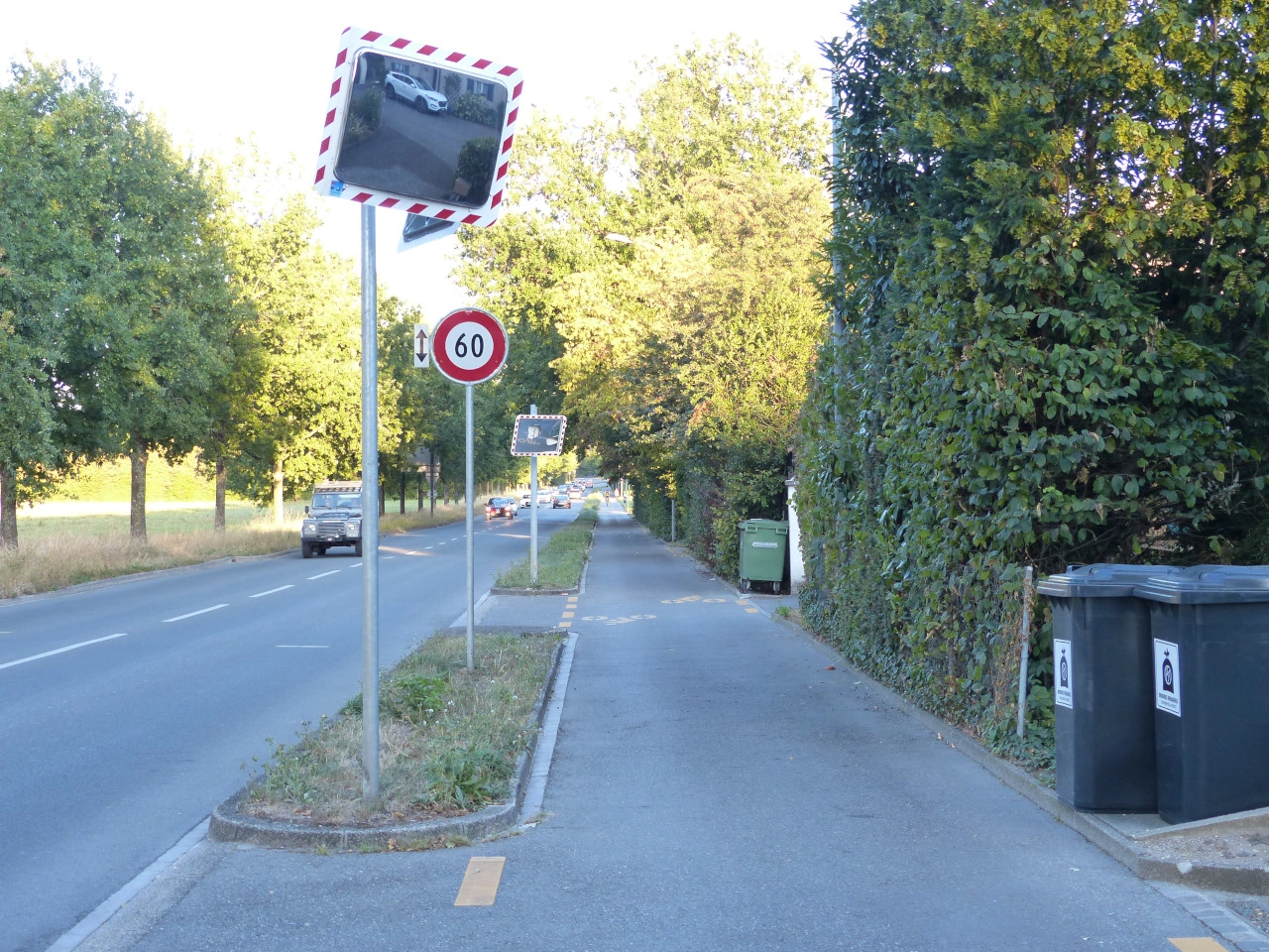
What is a traffic mirror?
A traffic mirror is a convex roadside mirror that helps road users see around an obstruction or into a road with limited visibility.
Where are traffic mirrors commonly installed?
They may be placed near intersections, narrow roads, bends, car-park exits, private driveways, tunnels or other locations where buildings, vegetation or road geometry obstruct the view.
Why is the mirror curved?
A convex surface provides a wider field of view than a flat mirror, allowing more of the approaching road to be seen.
Does a traffic mirror show an exact image?
No. The reflected image is distorted, and objects normally appear smaller and farther away than they really are.
Can you accurately judge speed in a traffic mirror?
Not reliably. The curved image makes it difficult to estimate how fast another road user is approaching.
Can you accurately judge distance in the mirror?
No. Distance can appear greater than it really is, so an approaching vehicle may reach the intersection sooner than expected.
Can the mirror create a blind area?
Yes. Its position and viewing angle may leave parts of the road outside the reflected image. Small cyclists, motorcycles or pedestrians may also be difficult to notice.
Does a traffic mirror give you priority?
No. It does not change priority. Drivers must continue to follow stop signs, give-way signs, traffic lights and the ordinary priority rules.
Does seeing an empty mirror mean the road is clear?
No. Another road user may be outside the reflected area, hidden by glare or too small to notice. Always check the road directly before proceeding.
Must you still stop at a stop sign?
Yes. The mirror does not replace the mandatory complete stop. Stop at the prescribed position, then use direct observation and the mirror as additional information.
Must you still give way?
Yes. You may proceed only when traffic with priority can continue without being forced to brake, stop or change direction.
How should you use a traffic mirror?
Approach slowly, stop when required and scan the mirror for movement. Then look directly in both directions and continue only after confirming that the road is clear.
Should you look only at the mirror?
No. Alternate between the mirror and direct observation. The mirror should supplement rather than replace normal checks.
Can rain affect a traffic mirror?
Yes. Rain, water droplets and spray may blur or partially obscure the reflected image.
Can frost or condensation affect it?
Yes. Dew, condensation, frost, ice or snow may make the mirror difficult or impossible to use.
Can sunlight cause problems?
Yes. Sunlight may create glare or reflections that hide approaching road users.
Can headlights be misleading at night?
Yes. Reflected headlights may make it difficult to determine the exact direction, distance or speed of an approaching vehicle.
Can the mirror move out of position?
Yes. Wind, impacts, vandalism, vibration or temperature changes may alter its orientation and make the reflected view inaccurate.
What if the mirror is dirty or damaged?
Do not rely on it. Proceed with additional caution and report the defect to the responsible road authority or property owner.
Does a traffic mirror impose a speed limit?
No. The applicable road or posted speed limit remains in force, but restricted visibility normally requires a lower approach speed.
Does it require drivers to sound the horn?
No. Use the horn only where local law permits it and a warning is reasonably necessary to prevent danger.
Can pedestrians and cyclists use the mirror?
Yes. It may help them observe approaching traffic, but they must also look directly and follow the applicable crossing and priority rules.
Can a private individual install a traffic mirror?
A mirror may generally be installed on private property with the owner’s permission, subject to local rules. Installing one on, above or beside a public road normally requires permission from the road authority.
Should a mirror replace better road design?
No. Removing vegetation, relocating parking, improving the intersection layout or changing traffic circulation may provide a safer and more reliable solution.
57. Notruftelefon
Ein Notruftelefon ist ein spezielles Telefon am Straßenrand oder in einem Tunnel, das Verkehrsteilnehmer direkt mit einer Notruf-, Verkehrsleit- oder Pannenhilfestelle verbindet. Notruftelefone befinden sich häufig in Tunneln, an Autobahnen oder an anderen Stellen, an denen ein Unfall, eine Panne oder ein Brand schnell gemeldet werden muss. Sie können der Leitstelle nützliche Standortinformationen liefern und auch dort verfügbar sein, wo Mobilfunkempfang schlecht ist.
What is an emergency telephone?
An emergency telephone is a dedicated telephone used to contact emergency services, a traffic-control centre or roadside assistance from the road.
Where are emergency telephones commonly found?
They are commonly installed in road tunnels, motorway emergency areas and other locations where rapid assistance may be needed.
When should you use an emergency telephone?
Use an emergency telephone to report situations such as a breakdown, accident, fire or other serious road emergency when assistance is required.
Why use an emergency telephone instead of a mobile phone?
An emergency telephone may allow the operator to identify your location immediately and connect you directly with the responsible control centre. It can also be useful where mobile reception is poor.
Are emergency telephones available on every motorway?
No. Their availability varies between countries and road networks. Mobile phones and emergency apps have replaced many traditional roadside call boxes.
Is an emergency telephone free to use?
Dedicated emergency telephones are generally intended for emergency assistance and do not require normal telephone payment, although systems vary between countries.
58. Staatsgrenze
Eine Staatsgrenze ist die rechtliche Grenze zwischen zwei Ländern. Ein Grenzschild kann das Land anzeigen, in das man einfährt, und daran erinnern, dass andere Verkehrsregeln, Geschwindigkeitsbegrenzungen, Verkehrszeichen, Fahrzeuganforderungen und Dokumentvorschriften gelten können.
Das Grenzschild selbst verpflichtet normalerweise nicht zum Anhalten. Pass-, Einreise- oder Zollkontrollen können an einer Kontrollstelle stattfinden; manche internationale Grenzen können aufgrund regionaler Abkommen jedoch ohne routinemäßige Kontrollen überquert werden.
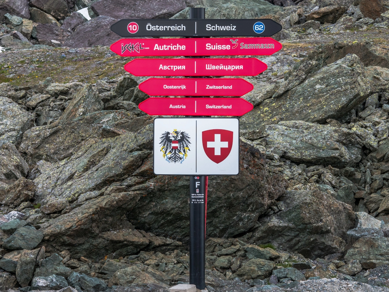
What is an international border?
An international border is the legal boundary between two countries.
How can you recognise an international border?
It may be identified by a country-name sign, national or regional symbols, flags, border posts, customs facilities or passport-control signs.
Does every international border have a road sign?
No. Borders may be marked differently, and some minor roads or open-border areas may have only a small identification sign or boundary marker.
Does a border sign require you to stop?
Not normally. Stop only when required by traffic lights, barriers, officers, customs signs, passport controls or another instruction.
When do the destination country’s traffic rules begin?
The new country’s traffic laws apply from the international boundary, not merely from the next town or major intersection.
Does the border sign itself impose the new rules?
No. The rules change because you have entered another country. The sign identifies that change of jurisdiction.
Can the driving side change at a border?
Yes. Where neighbouring countries use different driving sides, a specially designed road arrangement guides traffic safely from one side to the other.
Can speed limits change at the border?
Yes. The destination country may have different general limits for motorways, built-up areas, rural roads and particular vehicle categories.
Is the border sign a speed-limit sign?
No. Drivers must learn the destination country’s general limits and obey any regulatory signs displayed after crossing.
Can traffic-sign designs change?
Yes. Colours, symbols, shapes and road-marking conventions may differ, even when neighbouring countries follow similar international standards.
Can vehicle-equipment requirements change?
Yes. Requirements concerning safety vests, warning triangles, winter tyres, lights, toll equipment or environmental stickers may differ between countries.
Which documents may be required?
Depending on the journey, drivers may need a passport or identity card, driving licence, vehicle-registration document, insurance evidence, visa or customs documents.
Is a border check the same as customs control?
No. Border or immigration control concerns people and travel documents. Customs control principally concerns goods, cargo, money and applicable duties or restrictions.
Can immigration and customs controls occur together?
Yes. Both may operate at the same border facility even though they perform different legal functions.
Does every border have passport control?
No. Countries participating in an open-border area may normally cross internal borders without routine checks, although temporary controls may still be introduced.
Does every border have customs control?
No. Countries within a customs union may allow goods to move across their internal borders without ordinary customs duties or routine customs formalities.
Is an open border completely uncontrolled?
No. Police, customs and other authorities may still conduct lawful checks, enforce national rules and temporarily control the border where permitted.
May you cross the border anywhere?
Only where local law permits it. External or controlled borders may have to be crossed through an authorised border-crossing point during its operating hours.
Can a border crossing be temporarily closed?
Yes. Closures or restrictions may result from security measures, emergencies, severe weather, roadworks or administrative decisions.
Can certain vehicles be restricted?
Yes. A crossing may restrict heavy vehicles, dangerous goods, agricultural traffic, pedestrians or cyclists because of road design or border-control facilities.
May goods have to be declared?
Yes. Commercial goods, restricted products, goods exceeding personal allowances and certain amounts of cash may require declaration.
Do tolls or road charges change at the border?
They may. The destination country may use toll roads, vignettes, distance-based charges, low-emission zones or other payment systems.
Should you rely only on navigation software?
No. Navigation information may not include current border controls, vehicle restrictions or document requirements. Follow official signs and instructions.
What should you do before an international road journey?
Check the destination and transit countries’ traffic rules, required documents, insurance, vehicle equipment, tolls and border or customs requirements.
Do instructions from border officers override ordinary signs?
Yes. Follow lawful instructions from authorised border, police and customs officers, even when they temporarily differ from the normal traffic arrangement.
59. Fußgängerunterführung
Eine Fußgängerunterführung ist ein Durchgang, der Fußgängern ermöglicht, unter einer Straße, Bahnstrecke oder einem anderen Hindernis hindurchzugehen, ohne die Verkehrsroute höhengleich zu kreuzen. Sie ist eine Form der kreuzungsfreien Fußgängerquerung.
Fußgängerunterführungen können über Treppen, Rampen oder Aufzüge erreichbar sein und Teil eines größeren Gehwegenetzes sein. Radfahrer und andere Nutzer dürfen die Unterführung nur verwenden, wenn Bauweise, Beschilderung und örtliche Vorschriften dies erlauben.
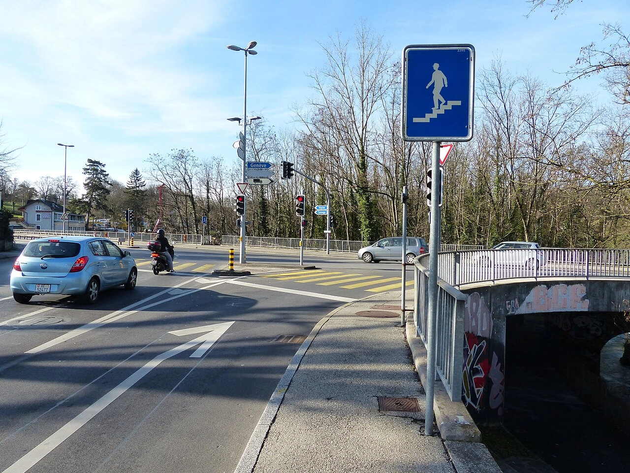
What is a pedestrian underpass?
A pedestrian underpass is a passage that allows pedestrians to cross beneath a road, railway or other obstacle without entering the traffic route above.
Why are pedestrian underpasses used?
They separate pedestrians from motor vehicles, trains or other traffic, reducing direct conflicts at busy or high-speed crossings.
Is a pedestrian underpass the same as a tunnel?
Not exactly. A pedestrian underpass is specifically intended to allow pedestrians to pass beneath an obstacle, while a tunnel can carry roads, railways, pedestrians or other forms of transport.
Is an underpass the same as a pedestrian overpass?
No. An underpass passes beneath the obstacle, while an overpass or footbridge carries pedestrians above it. Both provide grade-separated crossings.
Can cyclists use a pedestrian underpass?
This depends on the signs and design of the facility. Some underpasses are shared with cyclists, while pedestrian-only underpasses may require cyclists to dismount.
Can a pedestrian underpass have a cycle path?
Yes. Some underpasses contain separate or shared pedestrian and cycle facilities so both categories can cross safely away from motor traffic.
Can motor vehicles use a pedestrian underpass?
No when the passage is specifically reserved for pedestrians. Maintenance or emergency access may be permitted in exceptional circumstances.
Can an underpass be accessible to wheelchairs?
Yes, when suitably designed. Ramps or lifts can provide step-free access, although accessibility depends on the individual facility.
Do pedestrians have to follow signs inside an underpass?
Yes. Users must follow any signs indicating permitted users, direction of travel, separated sections or temporary closures.
Can a pedestrian underpass be temporarily closed?
Yes. Maintenance, flooding, construction, safety concerns or other circumstances may require temporary closure or diversion.
Does an underpass give pedestrians priority over traffic above?
The underpass physically separates the movements, so pedestrians do not directly cross the traffic route above. Priority rules still apply wherever the pedestrian route later crosses another roadway or cycle facility.
What should cyclists do in a pedestrian-only underpass?
Where cycling is not permitted, cyclists should dismount and continue on foot if pedestrian access with a bicycle is allowed.
60. Radroute
Eine Radroute ist eine geplante oder ausgeschilderte Strecke, die Radfahrer zwischen Orten oder durch ein bestimmtes Gebiet führen soll. Sie kann über Radwege, ruhige Straßen, gemeinsam genutzte Straßen, Grünwege oder andere zum Radfahren geeignete Strecken verlaufen.
Eine Radroute gibt Radfahrern nicht zwingend die ausschließliche Nutzung einer Straße oder eines Weges und darf nicht mit einem Radweg oder Radfahrstreifen verwechselt werden. Verkehrs- und Vorfahrtsregeln sowie zugelassene Nutzer richten sich nach den einzelnen Straßen und Wegen der Route sowie den örtlichen Zeichen und Vorschriften.
How can you recognise a cycling route?
Cycling routes are commonly indicated by direction signs, bicycle symbols, route numbers, colours or destination markers. The design of the signs and route-numbering system varies between countries and regions.
Do cyclists have to follow a cycling route?
Usually not. A cycling-route sign normally provides direction or route guidance rather than imposing a mandatory direction. However, separate mandatory traffic signs may require cyclists to use a particular cycle path or direction.
Is a cycling route the same as a cycle path?
No. A cycle path is a specific part of a road or separate path intended for cyclists under local traffic rules. A cycling route is an entire itinerary and may include cycle paths, ordinary roads, cycle streets and other types of infrastructure.
Are cycling routes reserved for cyclists?
Not necessarily. Many cycling routes use roads and paths that are also open to motor vehicles, pedestrians or other road users. Access is determined by the signs and rules applying to each individual section.
Do cyclists have priority on a cycling route?
Not automatically. Being on a designated cycling route does not normally change the priority rules. Cyclists must continue to obey traffic lights, give-way and stop signs, crossing rules and other applicable traffic regulations.
Does a cycling route always have cycle paths?
No. A route may combine dedicated cycle infrastructure with quiet streets, shared roads, rural roads and other suitable connections. The quality and level of separation from motor traffic can therefore change along the route.
Can a cycling route cross busy roads?
Yes. A cycling route may cross or temporarily follow busy roads. At such locations, cyclists must follow the crossing, priority and traffic-light rules indicated by local signs and markings.
Can other vehicles use roads forming part of a cycling route?
Yes, unless access is restricted by separate traffic signs or regulations. A cycling-route designation by itself does not normally prohibit cars, motorcycles or other vehicles from using an otherwise public road.
Can cycling routes be recreational or long-distance routes?
Yes. Cycling routes may be designed for daily travel, tourism or recreation. Some form part of regional, national or international networks and may be identified by route names or numbers.
What should you do when a cycling-route sign conflicts with a traffic sign?
Always follow the official traffic signs, signals and road markings. A route marker provides navigation and does not override a prohibition, mandatory direction, road closure or other traffic regulation.
61. Aufhebung einer Beschränkung
Aufhebung einer Beschränkung bedeutet das Ende einer oder mehrerer örtlicher Verkehrsregelungen, die auf dem vorherigen Straßenabschnitt für Fahrzeuge galten. Sie kann durch ein besonderes Ende-Zeichen, die durchgestrichene Version eines früheren Beschränkungszeichens oder ein anderes Zeichen angezeigt werden, das eine neue Regel festlegt.
Nach einem solchen Zeichen müssen Fahrer die allgemeinen Verkehrsregeln und alle neu geltenden Beschränkungen beachten. Es bedeutet nicht, dass hinter dem Zeichen keinerlei Geschwindigkeitsbegrenzungen oder Verkehrsregeln gelten.
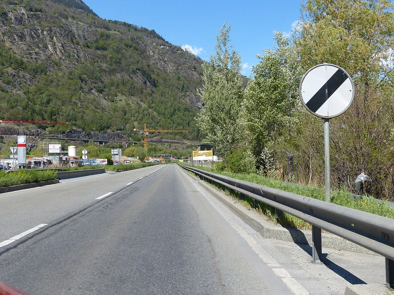
What does de-restriction mean?
De-restriction means that a previously imposed local traffic restriction has ended.
Does de-restriction mean there are no speed limits?
No. When a local restriction ends, the normal speed limit and other traffic rules applicable to that road still remain in force.
How is the end of a restriction indicated?
Depending on the country, it may be indicated by an end-of-restriction sign, a crossed-out restriction sign or another sign introducing a new rule.
62. Parken
Parken bedeutet, ein Fahrzeug für eine gewisse Zeit an einer Stelle abzustellen, statt nur kurz wegen der Verkehrslage oder einer unmittelbaren Notwendigkeit anzuhalten. Viele Länder unterscheiden Parken von einem kurzen Halt zum Ein- oder Aussteigenlassen von Personen oder zum Be- oder Entladen von Gütern; die genaue rechtliche Definition unterscheidet sich jedoch.
Parken kann durch Verkehrszeichen, Fahrbahnmarkierungen, Parkzonen und örtliche Vorschriften erlaubt, eingeschränkt, reserviert, zeitlich begrenzt oder verboten sein. Fahrer müssen so parken, dass keine Gefahr oder unnötige Behinderung entsteht, und Bedingungen zu Gebühren, Genehmigungen, Fahrzeugkategorien oder maximaler Parkdauer einhalten.
What is the difference between parking and stopping?
Parking generally means leaving a vehicle stationary for longer than a brief stop required for passengers, loading or unloading. A vehicle stopped because of traffic lights, congestion, an emergency or another traffic condition is normally not considered parked. The precise legal definitions vary between countries.
How can you tell where parking is allowed?
Look for parking signs, prohibition signs, road markings and parking-zone signs. Local rules may also permit parking along certain roads even when individual parking spaces are not marked.
Can you park anywhere if there is no sign prohibiting parking?
No. General traffic rules can prohibit parking even when no specific prohibition sign is present. Common examples include locations where a parked vehicle would obstruct visibility, crossings, intersections, cycle facilities or the movement of other traffic.
Can you park on a pavement or sidewalk?
Parking on a pavement or sidewalk is prohibited or restricted in many countries unless signs or markings specifically allow it. Vehicles must not force pedestrians into the roadway or block an accessible pedestrian route.
Can you park near a pedestrian crossing?
Parking on or close to a pedestrian crossing is generally restricted because a vehicle can hide pedestrians from approaching drivers. The required clearance distance varies between countries.
Can you park close to an intersection?
Many countries prohibit parking within a specified distance of an intersection because parked vehicles can reduce visibility and obstruct turning traffic. Follow the local distance requirements and any signs or markings.
What does a parking sign mean?
A parking sign identifies a place or area where parking is permitted or regulated. Additional signs or panels may specify time limits, payment requirements, vehicle categories, permits or particular parking arrangements.
How does paid parking work?
Where parking is subject to payment, drivers must follow the instructions displayed locally. Payment may be made through a parking meter, ticket machine, mobile application or another authorised system. The permitted duration and charging periods vary by location.
Who may use an accessible parking space?
Spaces marked for people with disabilities are reserved for vehicles displaying or registered with the required disability parking permit. Eligibility, permit display requirements and parking privileges depend on national and local law.
Can you leave a vehicle parked for an unlimited time?
Not necessarily. Local rules may impose a maximum parking duration, even where parking is otherwise permitted. Different limits may apply to abandoned, commercial, heavy or recreational vehicles.
63. Parkverbot
Parkverbot bedeutet, dass Fahrzeuge an der Stelle oder auf dem von der Regel erfassten Straßenabschnitt nicht geparkt werden dürfen. Je nach örtlichem Recht kann ein Fahrer dennoch kurz zum Ein- oder Aussteigenlassen von Personen oder zum Be- oder Entladen von Gütern anhalten, sofern nicht auch das Halten verboten ist.
Ein Parkverbot kann dauerhaft oder nur zu bestimmten Zeiten, Tagen, für bestimmte Fahrzeugkategorien oder Straßenabschnitte gelten. Genaue Reichweite und Ausnahmen ergeben sich aus Verkehrszeichen, Zusatztafeln, Fahrbahnmarkierungen und örtlichen Verkehrsregeln.
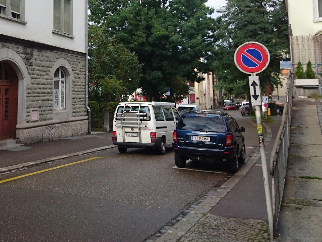
What does a no-parking sign mean?
A no-parking sign prohibits leaving a vehicle parked in the area or along the section of road to which the restriction applies. The exact legal definition of parking and the extent of the prohibition vary between countries.
Is no parking the same as no stopping?
No. A no-parking restriction commonly still permits certain brief stops, such as picking up or dropping off passengers or loading or unloading goods. A no-stopping restriction is stricter and generally prohibits voluntary stopping as well as parking.
Can you wait in your vehicle where parking is prohibited?
Remaining inside the vehicle does not necessarily mean that it is not parked. If the vehicle remains stationary beyond what local law permits as a brief stop, it may legally be considered parked even when the driver stays inside.
Can you pick up or drop off passengers in a no-parking area?
Often yes, if stopping is permitted and the vehicle remains there only as long as reasonably necessary for passengers to get in or out. Local rules may impose stricter restrictions at particular locations.
Can you load or unload goods where parking is prohibited?
In many countries, genuine loading or unloading is treated as stopping rather than parking and may therefore be permitted. The vehicle should remain there only for the time reasonably necessary for the activity.
How far does a no-parking restriction apply?
This depends on the country's signing rules. The restriction may continue to the next intersection, an end sign, a stated distance or the end of a designated zone. Supplementary arrows or distance panels may indicate its exact extent.
Does a no-parking sign apply on both sides of the road?
Usually a roadside no-parking sign applies only to the side of the road on which it is placed, unless it forms part of a zonal restriction or local signs indicate otherwise.
Can a no-parking restriction apply only at certain times?
Yes. A supplementary panel may restrict the prohibition to particular hours, days or periods. Outside those periods, parking may be permitted if no other rule prohibits it.
Can a no-parking restriction apply only to certain vehicles?
Yes. Additional signs or symbols may make a parking restriction applicable to particular vehicle categories, such as heavy vehicles, motorcycles or other specified vehicles.
Can you park immediately after a no-parking sign ends?
Only if parking is otherwise legal. The end of a specific no-parking restriction does not override general parking prohibitions near crossings, intersections, driveways, traffic signs or other protected locations.
64. Halteverbot
Halteverbot bedeutet, dass Fahrzeuge an der angegebenen Stelle freiwillig überhaupt nicht anhalten dürfen, auch nicht kurz zum Ein- oder Aussteigenlassen von Personen oder zum Be- und Entladen. Es ist eine strengere Beschränkung als ein Parkverbot.
Ein Halteverbot kann durch Verkehrszeichen, Fahrbahnmarkierungen oder örtliche Verkehrsregeln angezeigt werden. Fahrer sollten bis zu einer Stelle weiterfahren, an der Halten erlaubt ist, sofern sie nicht durch Verkehrslage, Notfall oder eine andere gesetzliche Pflicht zum Anhalten gezwungen sind.
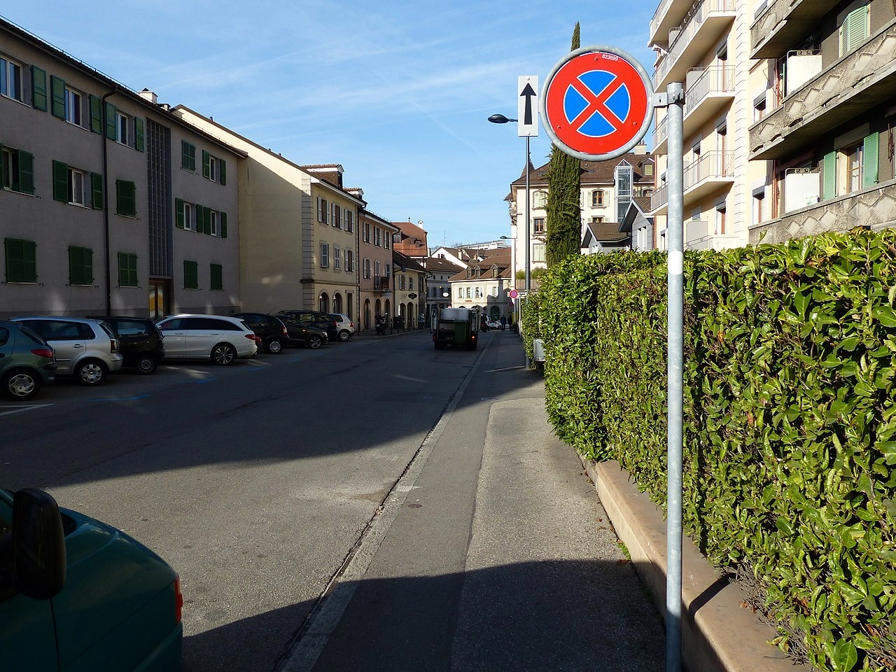
What does a no stopping restriction mean?
It means that a driver may not voluntarily stop the vehicle in the restricted area. The prohibition normally includes stopping to pick up or drop off passengers or to load or unload goods.
What is the difference between no stopping and no parking?
No stopping is the stricter restriction. A no-parking rule may still allow a brief stop for activities such as picking up passengers or loading goods, while a no-stopping rule prohibits these voluntary stops as well.
Can you stop in a no-stopping area during an emergency?
A driver may have to stop because of an emergency, traffic conditions, a red light, police instructions or another situation outside the driver's control. Such compulsory stops are generally different from voluntarily stopping the vehicle.
65. Parkscheibe
Eine Parkscheibe ist ein Hilfsmittel, mit dem die Ankunftszeit eines Fahrzeugs in einem Bereich mit begrenzter Parkdauer angezeigt wird. Der Fahrer stellt die Scheibe auf die vorgeschriebene Ankunftszeit und legt sie gut sichtbar im Fahrzeug aus.
Parkscheiben werden häufig in blauen Zonen oder anderen zeitlich begrenzten Parkbereichen verwendet. Zulässige Parkdauer, Betriebszeiten und Einstellweise richten sich nach nationalen oder örtlichen Regeln und den vorhandenen Verkehrszeichen.
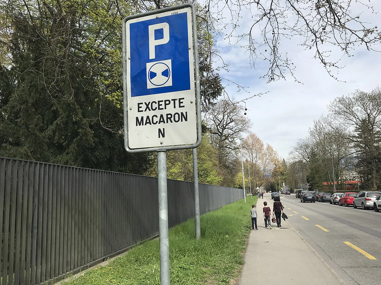
What is a parking disc used for?
A parking disc shows when a vehicle arrived at a time-limited parking space. It allows parking enforcement officers to determine whether the permitted parking period has been exceeded.
Where should a parking disc be displayed?
It should normally be placed clearly visible behind the windscreen or in another position specified by local traffic rules so that the indicated time can be read from outside the vehicle.
Can you change the time on a parking disc without moving the vehicle?
Generally no where the applicable rules prohibit extending the parking period in this way. The vehicle normally has to leave the parking space before a new parking period can begin.
66. Rückwärtsfahren
Rückwärtsfahren bedeutet, ein Fahrzeug rückwärts zu bewegen. Es wird häufig beim Parken, beim Verlassen enger Bereiche oder zum Umsetzen eines Fahrzeugs genutzt, wenn Vorwärtsfahren nicht praktisch ist.
Vor dem Rückwärtsfahren sollte der Fahrer Spiegel und tote Winkel prüfen, den Bereich rund um das Fahrzeug sorgfältig beobachten und sicherstellen, dass der Raum hinter dem Fahrzeug frei ist. Rückwärtsfahren sollte langsam und nur so lange wie nötig erfolgen, weil die Sicht nach hinten häufig eingeschränkt ist.

What should you check before reversing?
Check behind and around the vehicle for pedestrians, cyclists, other vehicles and obstacles. Use mirrors and cameras where available, but also look directly because monitoring systems can have blind spots.
Who has priority when a vehicle is reversing?
In many countries, reversing is treated as a manoeuvre and the reversing driver must give way to other road users. The exact legal requirements depend on national traffic rules.
Should you reverse for a long distance?
No. Reversing should normally be limited to the distance necessary to complete the manoeuvre safely. Driving forward generally provides better visibility and vehicle control.
67. Wenden
Ein Wendemanöver ist ein Fahrmanöver, bei dem ein Fahrzeug umkehrt, um in die entgegengesetzte Richtung weiterzufahren. Dabei wird normalerweise ein Teil der Fahrbahn gekreuzt und anschließend in Gegenrichtung wieder in den Verkehr eingefahren.
Vor dem Wenden sollte der Fahrer den umliegenden Verkehr, Fußgänger und Radfahrer prüfen, bei Bedarf blinken und sicherstellen, dass ausreichend Sicht und Platz für das sichere Manöver vorhanden sind. Wenden kann durch Verkehrszeichen oder auf bestimmten Straßentypen verboten sein.
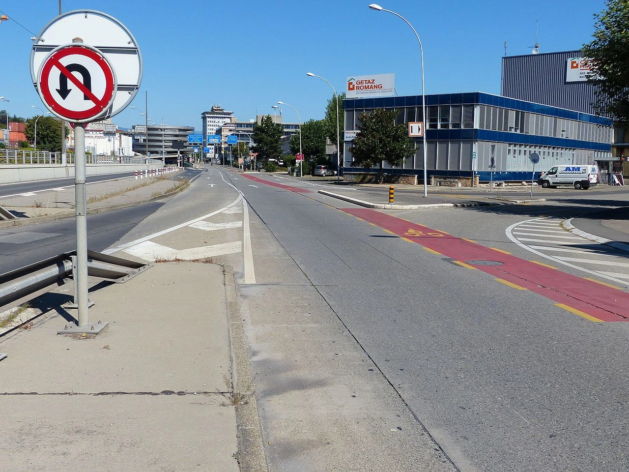
What is a U-turn?
A U-turn is a manoeuvre used to reverse a vehicle's direction so that it continues along the road in the opposite direction.
What should you check before making a U-turn?
Check traffic in all relevant directions, mirrors and blind spots, and look for pedestrians, cyclists and other road users. Make sure there is sufficient visibility and space and that the manoeuvre is permitted.
Can you make a U-turn anywhere?
No. U-turns may be prohibited by traffic signs or road rules and should never be attempted where visibility, road layout or traffic conditions make the manoeuvre unsafe.
68. Stau
Ein Stau ist eine Situation, in der der Verkehr stark überlastet ist und Fahrzeuge über längere Zeit sehr langsam fahren oder stehen. Häufige Ursachen sind hohe Verkehrsbelastung, Unfälle, Straßenarbeiten, Fahrstreifensperrungen oder schlechtes Wetter. Fahrer sollten geduldig bleiben, sicheren Abstand halten, unnötige Fahrstreifenwechsel vermeiden und auf Motorräder, Einsatzfahrzeuge sowie plötzliches Bremsen achten. Wenn Fahrstreifen im Stau zusammengeführt werden, können örtliche Regeln das Reißverschlussverfahren vorschreiben.
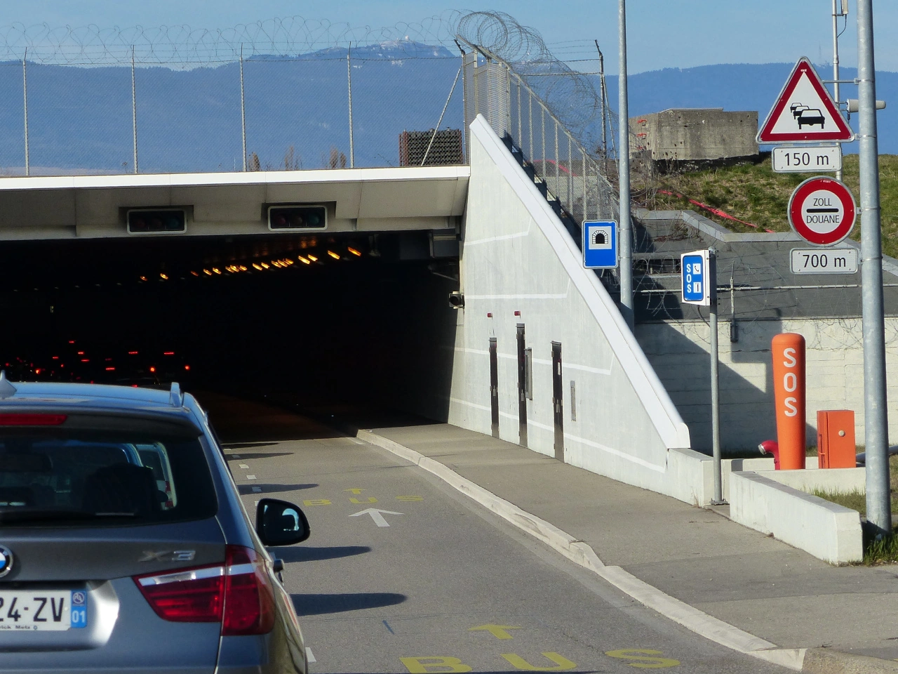
What is a traffic jam?
A traffic jam occurs when traffic becomes congested and vehicles move slowly or remain stationary because the road cannot accommodate the normal flow of traffic.
What causes traffic jams?
Common causes include heavy traffic, accidents, roadworks, lane closures, bottlenecks and poor weather.
How should you drive in a traffic jam?
Keep a safe distance, avoid sudden braking and unnecessary lane changes, and remain alert for changing traffic conditions and emergency vehicles.
Should you change lanes frequently in a traffic jam?
Usually not. Frequent lane changes can disrupt traffic flow and increase the risk of collisions. Change lanes only when necessary and safe.
What is zipper merging?
Zipper merging is a system where drivers use all available lanes until a lane ends or becomes blocked and then merge alternately into the remaining lane.
Should you leave space for emergency vehicles in a traffic jam?
Yes. Many countries require or recommend drivers to create space for emergency vehicles when traffic becomes congested or stationary.
69. Umleitung
Eine Umleitung ist eine vorübergehende alternative Strecke, die genutzt wird, wenn die normale Straße gesperrt, blockiert oder nicht verfügbar ist. Umleitungen werden häufig bei Straßenarbeiten, Unfällen, öffentlichen Veranstaltungen, Überschwemmungen oder anderen Störungen eingerichtet. Fahrer sollten den vorübergehenden Wegweisern aufmerksam folgen, bei Bedarf die Geschwindigkeit verringern und mit unbekannten Straßen, veränderten Vorfahrtsregelungen oder zusätzlichem Verkehr auf der Ersatzstrecke rechnen.
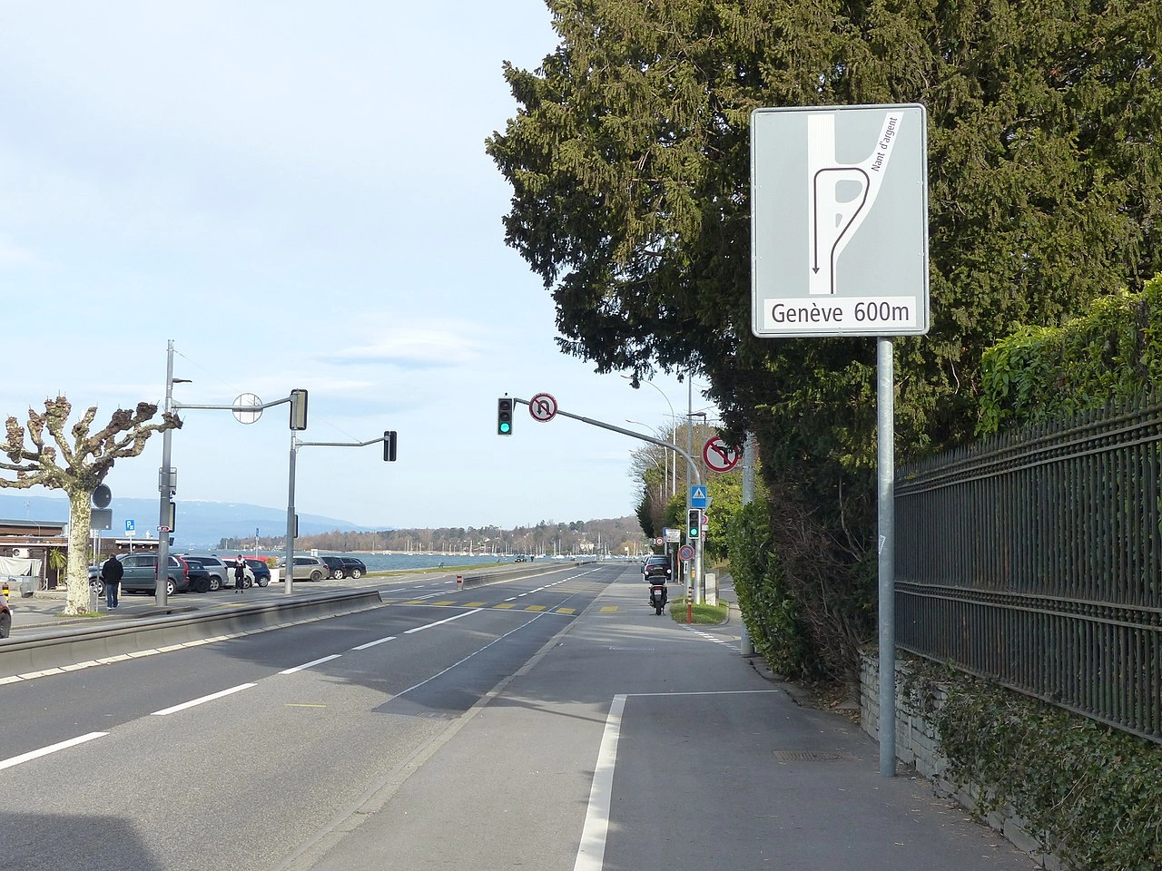
What is a detour?
A detour is an alternative route that directs traffic around a closed, blocked or restricted section of road.
Why are detours used?
Detours may be introduced because of roadworks, accidents, flooding, public events or other temporary obstructions that prevent normal use of the road.
Do you have to follow a detour?
Drivers must follow mandatory traffic signs and authorised traffic directions. A signed detour should be followed when the normal route is closed or restricted.
Are detours always temporary?
Most detours are temporary and remain in place only while the normal route is unavailable, although they can sometimes last for an extended period during major works.
Should you drive differently on a detour?
Yes. Detours may use unfamiliar or smaller roads, so drivers should reduce speed where necessary, watch for changed priorities and follow temporary signs carefully.
What is the difference between a detour and a diversion?
Detour and diversion generally describe the same concept: an alternative route around a road that cannot be used normally. The preferred term varies between countries and languages.
70. Ungeregelte Kreuzung
Eine ungeregelte Kreuzung ist eine Kreuzung, an der die Vorfahrt nicht ausdrücklich durch Ampeln, eine befugte Person oder vorfahrtregelnde Verkehrszeichen festgelegt ist. Fahrer müssen daher anhand der in dem jeweiligen Land geltenden allgemeinen Verkehrsregeln bestimmen, wer Vorfahrt hat.
Die Regel unterscheidet sich je nach Land und kann Vorfahrt von rechts, Vorfahrt von links oder eine andere allgemeine Vorfahrtsregel vorsehen. Fahrer sollten sich einer ungeregelten Kreuzung vorsichtig nähern, den Verkehr aus allen Richtungen beobachten und niemals annehmen, dass eine breitere oder stärker befahrene Straße automatisch Vorfahrt hat.
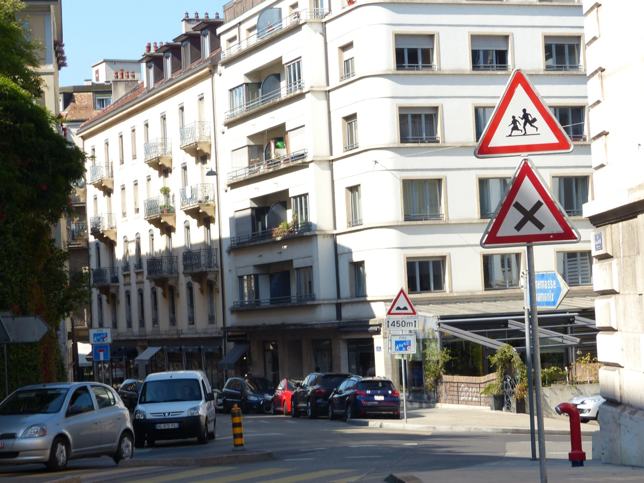
What is an uncontrolled crossroad?
An uncontrolled crossroad is an intersection where priority is not specifically assigned by traffic lights, an authorised person or priority signs. Drivers must use the default priority rules of the country.
Who has priority at an uncontrolled crossroad?
This depends on the local traffic law. Some countries use priority from the right, while others use different rules. Drivers should know the default intersection rule of the country in which they are driving.
Does the wider road automatically have priority?
Not necessarily. The width, surface or amount of traffic on a road does not by itself determine priority unless local law specifically provides otherwise.
Should you slow down at an uncontrolled crossroad?
Yes. Approach at a speed that allows you to observe approaching traffic, determine who has priority and stop safely if necessary.
Do cyclists have to follow the priority rules at an uncontrolled crossroad?
Yes. Cyclists generally follow the applicable intersection priority rules unless a specific cycle facility, sign or local rule provides otherwise.
Does driving straight ahead automatically give you priority?
No. Continuing straight ahead does not automatically give priority over traffic approaching on another road. The applicable priority rules must still be followed.
Does turning right or left change the priority rules?
Turning may create additional obligations, particularly towards pedestrians, cyclists or opposing traffic. Drivers must follow both the intersection priority rule and the rules governing the intended turn.
What if two vehicles reach an uncontrolled crossroad at the same time?
Apply the country's default priority rule. Do not rely simply on which vehicle appears to have arrived first unless local law specifically uses that rule.
What if the traffic lights at an intersection are not working?
The intersection is not necessarily completely uncontrolled. Priority signs, road markings and default priority rules may still determine who must give way. Drivers should approach with particular caution.
What should you do if you are unsure who has priority?
Reduce speed and be prepared to stop. Never force your way through an intersection simply because the priority situation is unclear.
71. Fahrbahnschäden
Eine Warnung vor Fahrbahnschäden weist darauf hin, dass die Straße voraus uneben, beschädigt oder in schlechtem Zustand sein kann und dadurch Stabilität, Lenkung oder Bremsen eines Fahrzeugs beeinträchtigt werden können. Die Gefahr kann Bodenwellen, Vertiefungen, Schlaglöcher, beschädigten Belag oder andere Unebenheiten umfassen.
Fahrer sollten bei Bedarf die Geschwindigkeit verringern, ausreichend Abstand halten und auf unebenem Untergrund abruptes Lenken oder Bremsen vermeiden. Die genaue Bedeutung und Gestaltung des Warnzeichens unterscheiden sich je nach Land; daher sind die örtlichen Verkehrszeichen und Vorschriften zu beachten.
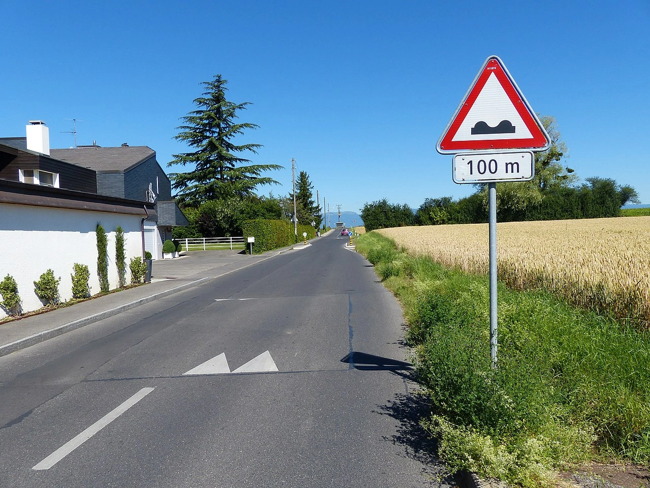
What does a road surface warning mean?
A road surface warning indicates that the surface ahead may be uneven, damaged or otherwise capable of affecting the safe movement of vehicles.
What kinds of road defects can the warning indicate?
Depending on the country, it may warn of bumps, depressions, potholes, broken pavement, uneven repairs or other surface irregularities.
What should you do when you see a road surface warning?
Reduce speed where necessary, increase your awareness of the road ahead and be prepared for changes in the vehicle's stability or direction.
Does a road surface warning impose a specific speed limit?
Not normally. A warning sign alerts drivers to a hazard rather than establishing a numerical speed limit. A separate speed-limit sign may be used where a particular maximum speed is required.
Should you brake before reaching an uneven road surface?
Where slowing is necessary, it is generally safer to reduce speed before reaching the irregular surface rather than braking sharply while travelling over it.
Why can an uneven road surface be dangerous?
A severe surface irregularity can affect tyre contact, steering, braking and vehicle stability. It can also damage tyres, wheels or suspension components.
Are motorcycles and bicycles particularly affected by uneven surfaces?
Yes. Two-wheeled vehicles can be particularly sensitive to potholes, ridges and other irregularities because these hazards may disturb their balance or alter their direction suddenly.
Is an uneven-road warning the same as a slippery-road warning?
No. An uneven-road warning concerns the physical condition or shape of the road surface. A slippery-road warning concerns reduced tyre grip caused by the surface or conditions such as water, ice, mud or other substances.
Can the warning apply over a longer section of road?
Yes. A supplementary sign may indicate the distance to the hazard or the length of the affected section, depending on the country's traffic-sign system.
Should you increase your following distance on a poor road surface?
Yes, when conditions require it. Additional distance provides more time to react if the vehicle ahead slows suddenly to avoid a pothole or other surface defect.
72. Ausfahrt
Eine Ausfahrt ist eine ausgewiesene Strecke oder Stelle, an der Verkehr eine Straße, Autobahn, Schnellstraße oder andere Hauptverkehrsroute verlässt. Auf Hochgeschwindigkeitsstraßen führt eine Ausfahrt normalerweise von der Hauptfahrbahn auf einen Ausfahrstreifen oder eine Rampe, die mit einer anderen Straße oder einem Ziel verbunden ist.
Fahrer sollten vor einer Ausfahrt Wegweiser und Fahrbahnmarkierungen beachten, sich rechtzeitig in den richtigen Fahrstreifen einordnen und ihre Geschwindigkeit nach Verlassen des Hauptverkehrsflusses bei Bedarf anpassen.
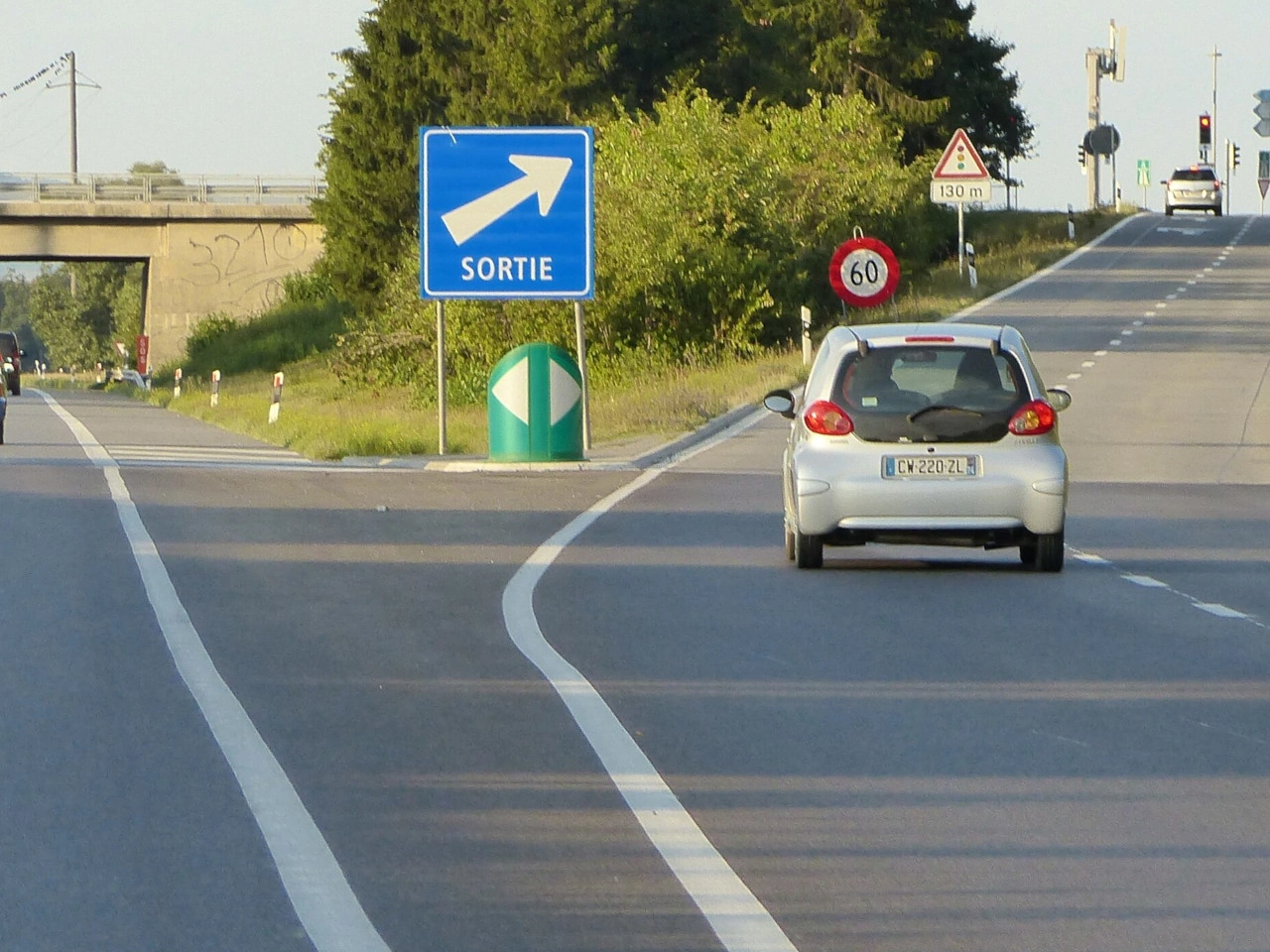
What is a road exit?
An exit is a designated route or point that allows traffic to leave a road, motorway or expressway and continue toward another road or destination.
How should you prepare for an exit?
Check the direction signs, select the correct lane in good time, signal when required and avoid sudden lane changes when approaching the exit.
What should you do if you miss your exit?
Continue safely along the road and use a later exit or another permitted route. Do not stop, reverse or make a dangerous sudden manoeuvre simply to reach an exit you have missed.
73. Informationsstelle
Eine Informationsstelle ist ein ausgewiesener Ort, an dem Reisende Informationen über die Umgebung, örtliche Dienstleistungen, Sehenswürdigkeiten, Routen oder andere nützliche Einrichtungen erhalten können. Sie kann an einer Straße, auf einem Rastplatz, in einem Ort oder in der Nähe eines wichtigen Ziels liegen.
Informationsstellen werden häufig durch ein Service- oder Informationszeichen gekennzeichnet. Je nach Standort können sie Karten, Broschüren, Routeninformationen, touristische Hilfe oder digitale Besucherinformationen anbieten.
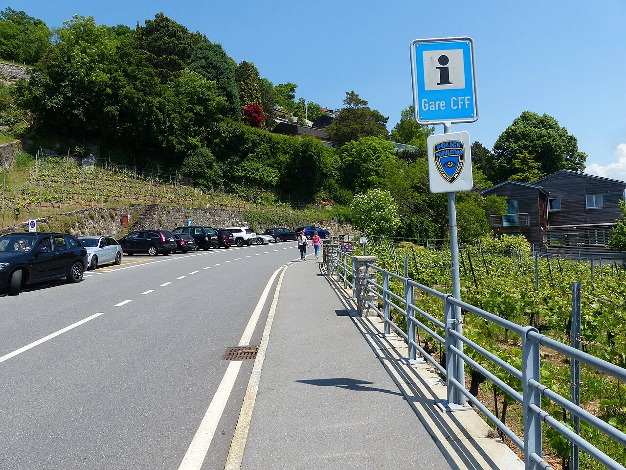
What is an information point?
An information point is a place where travellers can obtain information about local destinations, attractions, services, routes or other useful facilities.
What information can you find at an information point?
Depending on the location, an information point may provide maps, tourist information, directions, information about attractions and details about nearby services.
How is an information point indicated?
Many countries use a service or information sign to direct road users toward an information point. The exact symbol and sign design vary between countries.
74. Reiten
Reiten bezeichnet das Reiten und Aktivitäten mit Pferden und Reitern. Im Straßenverkehr können Reiter je nach Regeln und Infrastruktur Straßen, Reitwege oder speziell ausgewiesene Routen nutzen.
Fahrer, die sich Pferden und Reitern nähern, sollten die Geschwindigkeit verringern, ausreichend Abstand halten und plötzlichen Lärm oder Bewegungen vermeiden, die das Tier erschrecken könnten. Auch Reiter müssen die für sie geltenden Verkehrsregeln beachten.
What does equestrian mean in road traffic?
Equestrian refers to horse riding and, in a traffic context, particularly to people travelling on horseback or using designated horse-riding routes.
Where can equestrians ride?
Depending on local rules, riders may use roads, bridleways, paths or routes specifically designated for horse riding.
How should drivers behave near horse riders?
Drivers should slow down, leave plenty of space and pass calmly, avoiding sudden acceleration, horn use or other actions that could frighten the horse.
75. Notausgang
Ein Notausgang ist ein gekennzeichneter Fluchtweg, über den Verkehrsteilnehmer einen Tunnel oder eine andere geschlossene Verkehrsanlage bei einem schweren Ereignis wie Brand, Rauchentwicklung oder einem anderen Notfall verlassen können. Notausgänge führen in einen sichereren Bereich, der von der unmittelbaren Gefahr getrennt ist.
Im Notfall sollten Insassen ihr Fahrzeug verlassen, wenn eine Evakuierung erforderlich ist, und den Notausgangsschildern und Anweisungen folgen. Sie sollten sich von der Gefahr entfernen, statt im Tunnel zu bleiben oder zum Fahrzeug zurückzukehren.
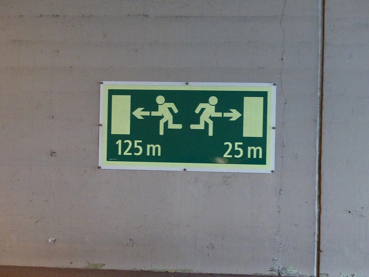
What is an emergency exit in a road tunnel?
An emergency exit is a designated escape route that allows people to leave the traffic area of a tunnel and reach a safer location during an emergency.
When should you use a tunnel emergency exit?
Use an emergency exit when evacuation is necessary because of fire, smoke or another serious danger, or when instructed to evacuate by tunnel personnel or emergency services.
Should you take your vehicle through an emergency exit?
No. Tunnel emergency exits are intended for people evacuating on foot. Leave the vehicle when necessary and follow the marked escape route towards safety.