

Here you can study for the exam. Look up keywords and learn definitions about all kind of subjects.
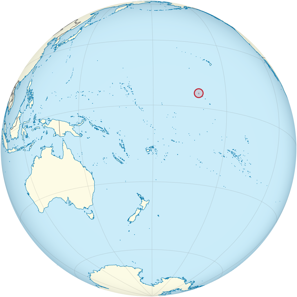
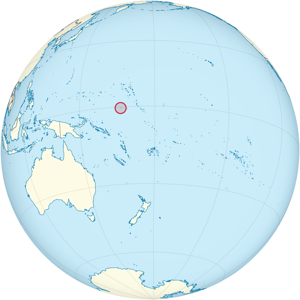
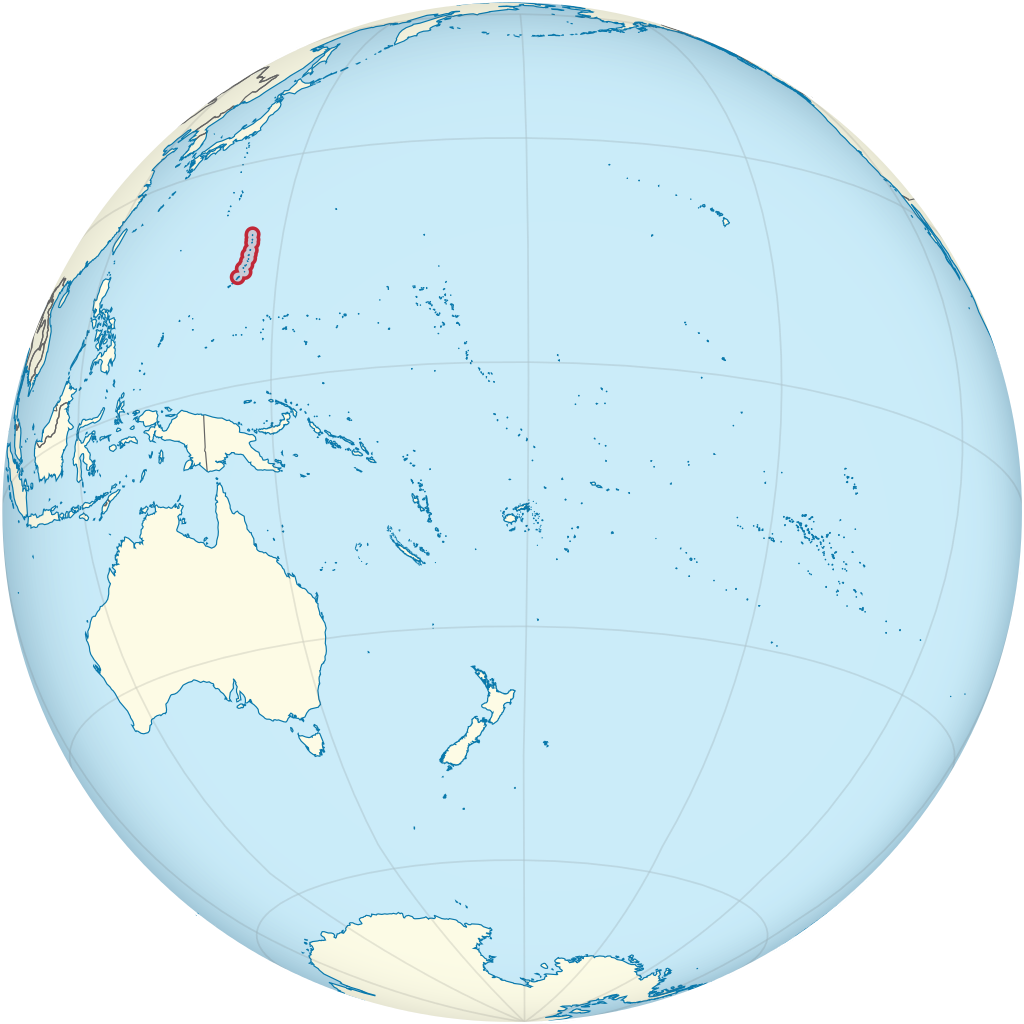
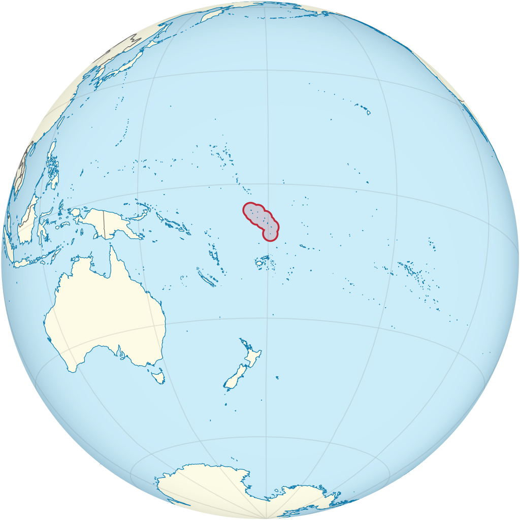
Kingman Reef /ˈkɪŋmən/ is a largely submerged, uninhabited, triangle-shaped reef, geologically an atoll, 9.0 nmi (20 km) east-west and 4.5 nmi (8 km) north-south, in the North Pacific Ocean, roughly halfway between the Hawaiian Islands and American Samoa. It has an area of 3 hectares (0.03 km2; 7.4 acres) and is one of the unincorporated territories of the United States in Oceania. The reef is administered by the United States Fish and Wildlife Service as the Kingman Reef National Wildlife Refuge. It is the northernmost of the Northern Line Islands and lies 36 nautical miles (67 km) northwest of the next closest island (Palmyra Atoll), and 930 nautical miles (1,720 km) south of Honolulu. The reef encloses a lagoon up to 53 fathoms (318 ft; 97 m) deep in its eastern part near the northeastern spit of land. The total area within the outer rim of the reef is 20 sq nmi (70 km2). There are two small strips (spits) of dry land composed of coral rubble and giant clamshells on the eastern rim with areas of 2 and 1 acre (0.8 and 0.4 ha) having a coastline of 2 miles (3 km), a short spit on the northeast side of the lagoon and a spit twice as long but thinner on its south side. The highest point on the reef is less than 5 feet (1.5 m) above sea level, which is wet or awash most of the time, making Kingman Reef a maritime hazard. It has no natural resources and supports no economic activity. (Source: Wikipedia.org, CC BY-SA)
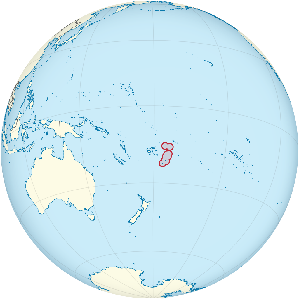
Kiribati (/ˌkɪrɪˈbæs, -ˈbɑːti/), officially the Republic of Kiribati (Gilbertese: [Ribaberiki] Kiribati), is an island country in Oceania in the central Pacific Ocean. The permanent population is over 119,000 (2020), more than half of whom live on Tarawa atoll. The state comprises 32 atolls and one remote raised coral island, Banaba. There is a total land area of 811 square kilometres (313 square miles) dispersed over 3.5 million km2 (1.4 million sq mi) of ocean. Their spread straddles the equator and the 180th meridian, although the International Date Line goes around Kiribati and swings far to the east, almost reaching the 150° W meridian. This brings Kiribati's easternmost islands, the southern Line Islands south of Hawaii, into the same day as the Gilbert Islands and places them in the most advanced time zone on Earth: UTC+14. Kiribati is the only country in the world to be situated in all four cardinal hemispheres. (Source: Wikipedia.org, CC BY-SA)
Minamitorishima (南鳥島, lit. 'Southern Bird Island'), also known as Marcus Island, is an isolated Japanese coral atoll in the northwestern Pacific Ocean, located some 1,848 kilometers (1,148 mi) southeast of Tokyo and 1,267 km (787 mi) east of the closest Japanese island, South Iwo Jima of the Ogasawara Islands, and nearly on a straight line between mainland Tokyo and Wake Island, 1,415 km (879 mi) further to the east-southeast. The closest island to Minamitorishima is East Island in the Mariana Islands, which is 1,015 km (631 mi) to the west-southwest. It is the easternmost territory belonging to Japan, and the only Japanese territory on the Pacific Plate, past the Japan Trench. Although small (1.51 km2 (1 sq mi)) it is of strategic importance, as it enables Japan to claim a 428,875 square kilometers (165,589.6 sq mi) exclusive economic zone in the surrounding waters. It is also the easternmost territory of Tokyo, being administratively part of Ogasawara village. There is no civilian population, except personnel of the Japan Meteorological Agency, JSDF, and Japan Coast Guard serving temporary tours of duty on the island. (Source: Wikipedia.org, CC BY-SA)
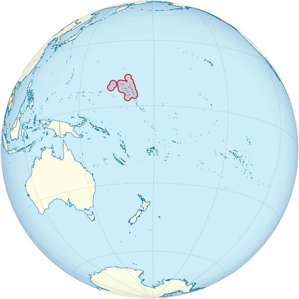
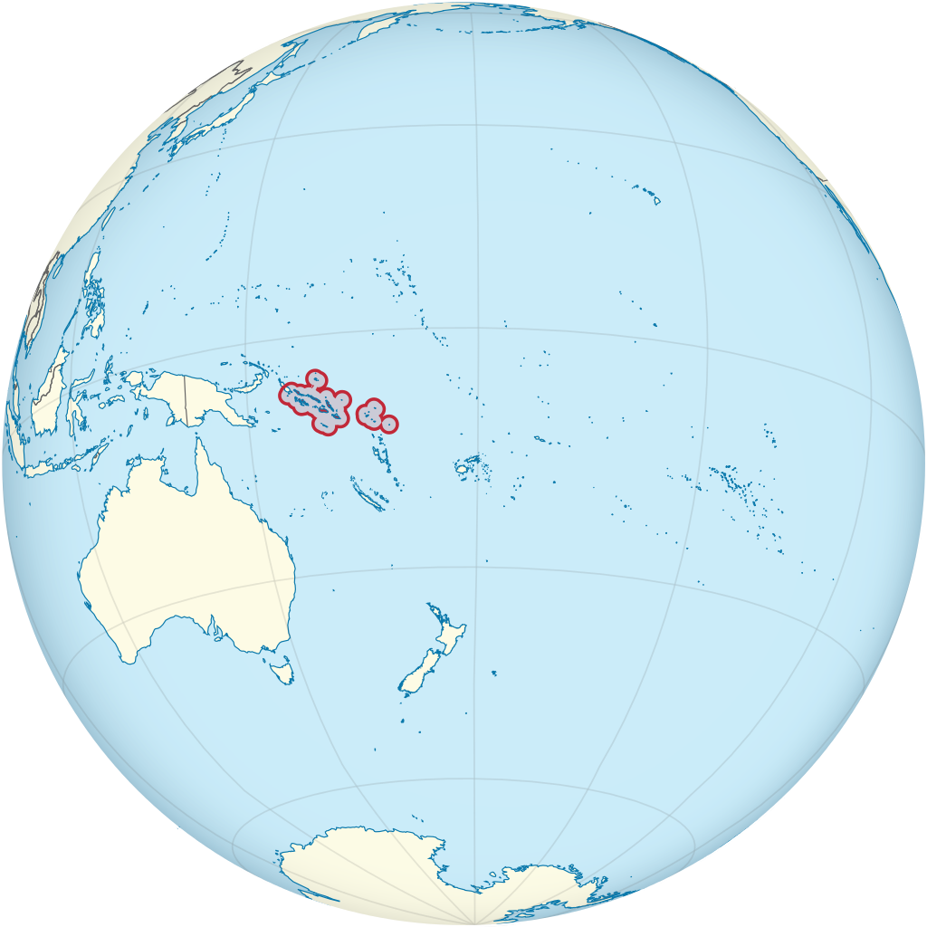
The Marshall Islands (Marshallese: Ṃajeḷ), officially the Republic of the Marshall Islands (Marshallese: Aolepān Aorōkin Ṃajeḷ), is an independent island country and microstate near the Equator in the Pacific Ocean, slightly west of the International Date Line. Geographically, the country is part of the larger island group of Micronesia. The country's population of 58,413 people (at the 2018 World Bank Census) is spread out over five islands and 29 coral atolls, comprising 1,156 individual islands and islets. The capital and largest city is Majuro. It has the largest portion of its territory composed of water of any sovereign state, at 97.87%. The islands share maritime boundaries with Wake Island to the north, Kiribati to the southeast, Nauru to the south, and Federated States of Micronesia to the west. About 52.3% of Marshall Islanders (27,797 at the 2011 Census) live on Majuro. In 2016, 73.3% of the population were defined as being 'urban'. The UN also indicates a population density of 760 inhabitants per square mile (295/km2), and its projected 2020 population is 59,190. (Source: Wikipedia.org, CC BY-SA)
Micronesia (UK: /ˌmaɪkrəˈniːziə/, US: /-ˈniːʒə/) is a subregion of Oceania, consisting of about 2,000 small islands in the western Pacific Ocean. It has a close shared cultural history with three other island regions: the Philippines to the west, Polynesia to the east, and Melanesia to the south—as well as with the wider community of Austronesian peoples. The region has a tropical marine climate and is part of the Oceanian realm. It includes four main archipelagos—the Caroline Islands, the Gilbert Islands, the Mariana Islands, and the Marshall Islands—as well as numerous islands that are not part of any archipelago. Human settlement of Micronesia began several millennia ago. The Micronesian people are considered, by linguistic, archaeological, and human genetic evidence, a subset of the sea-migrating Austronesian people, who include the Polynesian people and the Melanesian people. Based on the current scientific consensus, the Austronesian peoples originated from a prehistoric seaborne migration, known as the Austronesian expansion, from pre-Han Taiwan, at around 3000 to 1500 BCE. Austronesians reached the northernmost Philippines, specifically the Batanes Islands, by around 2200 BCE. Austronesians were the first people to invent oceangoing sailing technologies (notably catamarans, outrigger boats, lashed-lug boat building, and the crab claw sail), which enabled their rapid dispersal into the islands of the Indo-Pacific. From 2000 BCE they assimilated (or were assimilated by) the earlier populations on the islands in their migration pathway. (Source: Wikipedia.org, CC BY-SA)
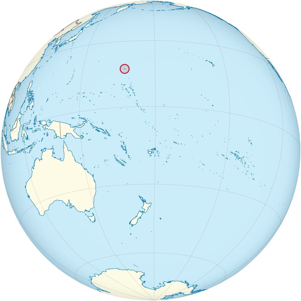
Midway Atoll (colloquial: Midway Islands; Hawaiian: Kauihelani, lit. 'the backbone of heaven'; Pihemanu, 'the loud din of birds') is a 2.4 sq mi (6.2 km2) atoll in the North Pacific Ocean. Midway Atoll is an insular area of the United States and is an unorganized and unincorporated territory. The largest island is Sand Island, which has housing and an airstrip. Immediately to the east of Sand Island across the narrow Brooks Channel is Eastern Island, which is uninhabited and no longer has any facilities. Forming a rough, incomplete circle around the two main islands and creating Midway Lagoon is Spit Island, a narrow reef. About 40 people live on the atoll, mostly staff of the U.S. Fish and Wildlife Service and contract workers. Visitation to the atoll is possible only for business reasons, which includes permanent and temporary staff, contractors, and volunteers, as the tourism program has been suspended due to budget cutbacks. In 2012, the last year that the visitor program was in operation, 332 people made the trip to Midway. Tours focused on both the unique ecology of Midway, as well as its military history. The economy is derived solely from governmental sources and tourist fees. Nearly all supplies must be brought to the island by ship or plane, although a hydroponic greenhouse and garden supply some fresh fruits and vegetables. (Source: Wikipedia.org, CC BY-SA)
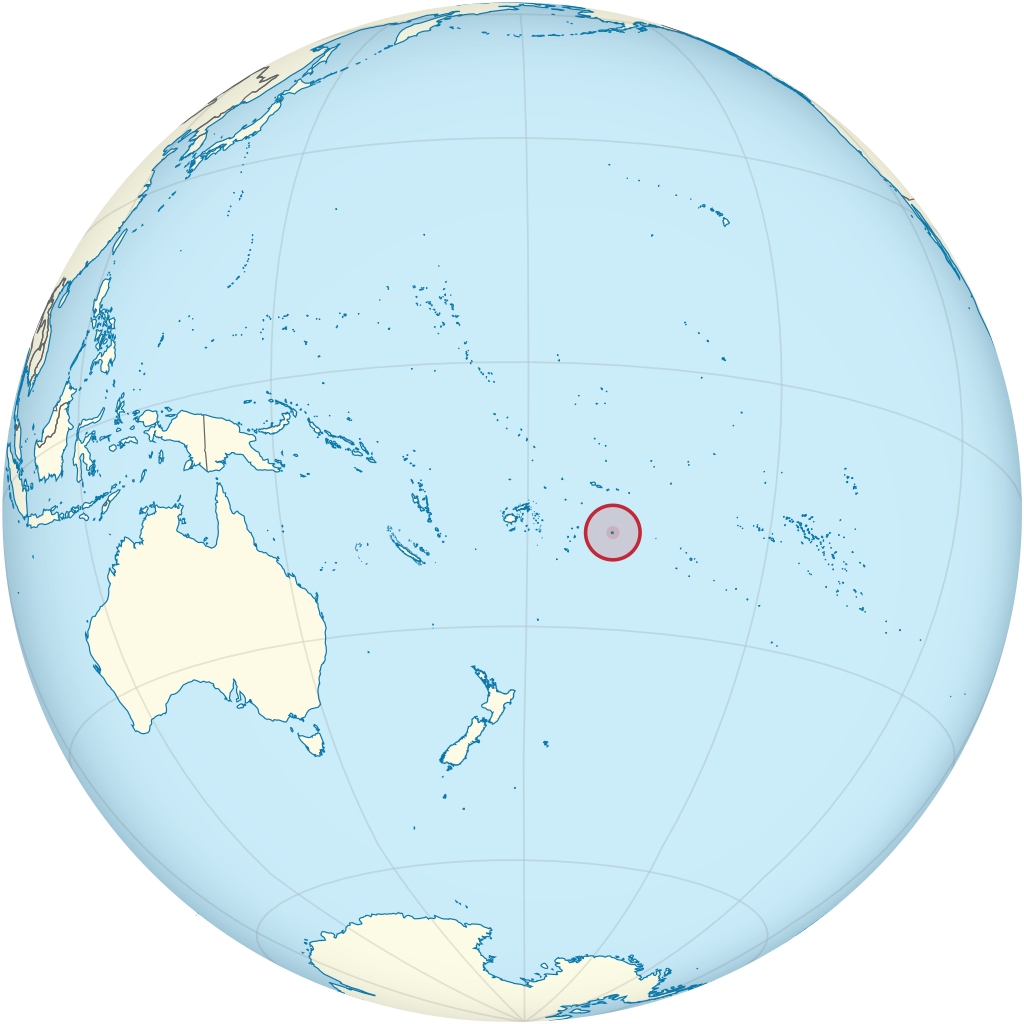
Nauru (/nɑːˈuːruː/ nah-OO-roo or /ˈnaʊruː/ NOW-roo; Nauruan: Naoero), officially the Republic of Nauru (Nauruan: Repubrikin Naoero) and formerly known as Pleasant Island, is an island country and microstate in Oceania, in the Central Pacific. Its nearest neighbour is Banaba Island in Kiribati, about 300 km (190 mi) to the east. It further lies northwest of Tuvalu, 1,300 km (810 mi) northeast of Solomon Islands, east-northeast of Papua New Guinea, southeast of the Federated States of Micronesia and south of the Marshall Islands. With only a 21 km2 (8.1 sq mi) area, Nauru is the third-smallest country in the world behind Vatican City and Monaco, making it the smallest republic as well as the smallest island nation. Its population of about 10,000 is the world's second-smallest (not including colonies or overseas territories), after Vatican City. Settled by people from Micronesia circa 1000 BCE, Nauru was annexed and claimed as a colony by the German Empire in the late 19th century. After World War I, Nauru became a League of Nations mandate administered by Australia, New Zealand, and the United Kingdom. During World War II, Nauru was occupied by Japanese troops, and was bypassed by the Allied advance across the Pacific. After the war ended, the country entered into United Nations trusteeship. Nauru gained its independence in 1968, and became a member of the Pacific Community (PC) in 1969. (Source: Wikipedia.org, CC BY-SA)
New Caledonia (/ˌkælɪˈdoʊniə/; French: Nouvelle-Calédonie) is a sui generis collectivity of overseas France in the southwest Pacific Ocean, south of Vanuatu, about 1,210 km (750 mi) east of Australia, and 17,000 km (11,000 mi) from Metropolitan France. The archipelago, part of the Melanesia subregion, includes the main island of Grande Terre, the Loyalty Islands, the Chesterfield Islands, the Belep archipelago, the Isle of Pines, and a few remote islets. The Chesterfield Islands are in the Coral Sea. French people, especially locals, call Grande Terre 'Le Caillou' ('the pebble'). New Caledonia has a land area of 18,576 km2 (7,172 sq mi) divided into three provinces. The North and South Provinces are on the New Caledonian mainland, while the Loyalty Islands Province is a series of three islands off the east coast of mainland. New Caledonia's population of 271,407 (October 2019 census) is of diverse origins and varies by geography; in the North and Loyalty Islands Provinces, the indigenous Kanak people predominate, while the wealthy South Province contains significant populations of European (Caldoches and Metropolitan French), Kanak, and Polynesian (mostly Wallisian) origin, as well as smaller groups of Southeast Asian, Pied-Noir, and North African heritage. The capital of New Caledonia is Nouméa. (Source: Wikipedia.org, CC BY-SA)
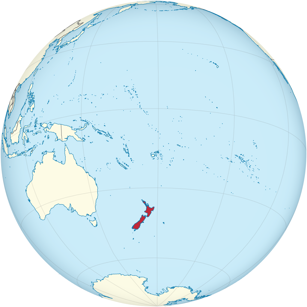
New Zealand (Māori: Aotearoa [aɔˈtɛaɾɔa]) is an island country in the southwestern Pacific Ocean. It consists of two main landmasses—the North Island (Te Ika-a-Māui) and the South Island (Te Waipounamu)—and over 700 smaller islands. It is the sixth-largest island country by area, covering 268,021 square kilometres (103,500 sq mi). New Zealand is about 2,000 kilometres (1,200 mi) east of Australia across the Tasman Sea and 1,000 kilometres (600 mi) south of the islands of New Caledonia, Fiji, and Tonga. The country's varied topography and sharp mountain peaks, including the Southern Alps, owe much to tectonic uplift and volcanic eruptions. New Zealand's capital city is Wellington, and its most populous city is Auckland. The islands of New Zealand were the last large habitable land to be settled by humans. Between about 1280 and 1350, Polynesians began to settle in the islands and then developed a distinctive Māori culture. In 1642, the Dutch explorer Abel Tasman became the first European to sight and record New Zealand. In 1840, representatives of the United Kingdom and Māori chiefs signed the Treaty of Waitangi, which in its English version declared British sovereignty over the islands. In 1841, New Zealand became a colony within the British Empire. Subsequently, a series of conflicts between the colonial government and Māori tribes resulted in the alienation and confiscation of large amounts of Māori land. New Zealand became a dominion in 1907; it gained full statutory independence in 1947, retaining the monarch as head of state. Today, the majority of New Zealand's population of 5.1 million is of European descent; the indigenous Māori are the largest minority, followed by Asians and Pacific Islanders. Reflecting this, New Zealand's culture is mainly derived from Māori and early British settlers, with recent broadening of culture arising from increased immigration. The official languages are English, Māori, and New Zealand Sign Language, with the local dialect of English being dominant. (Source: Wikipedia.org, CC BY-SA)
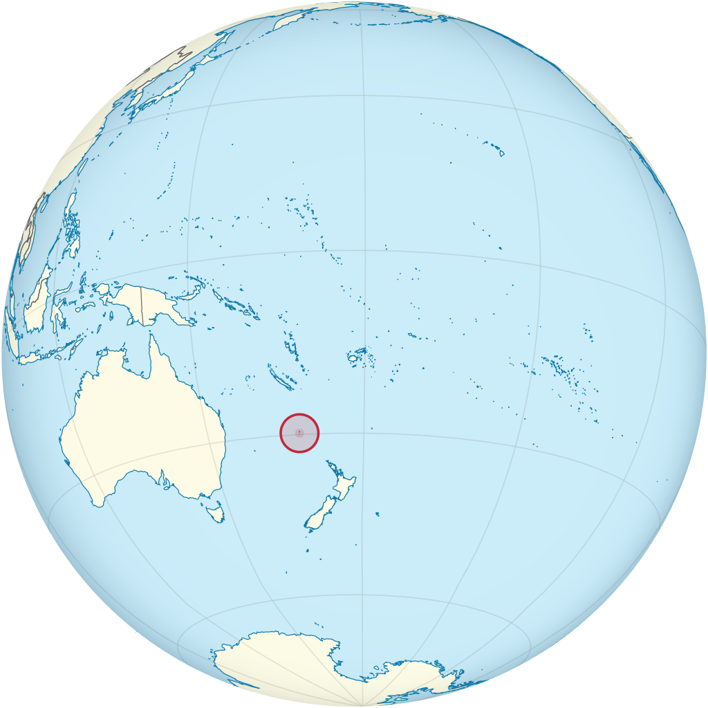
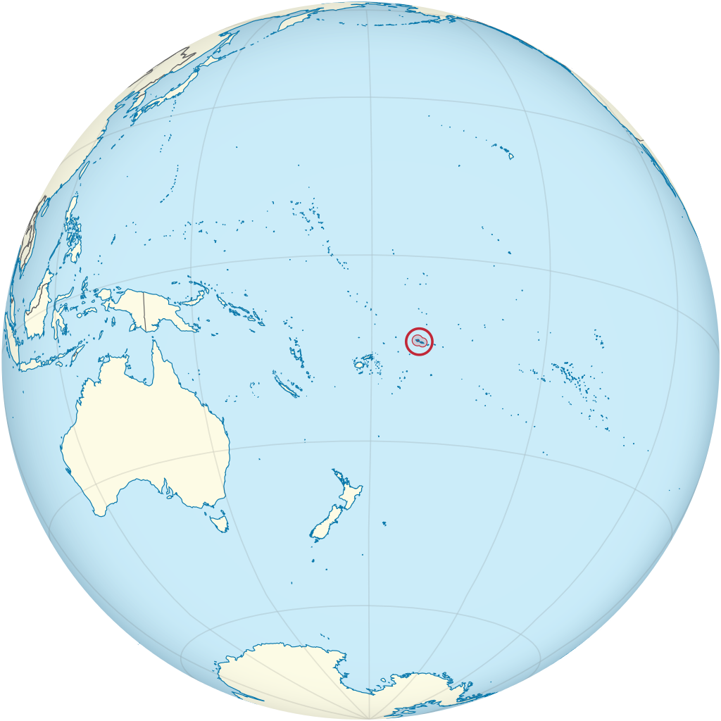
Niue (/ˈnjuːeɪ/, /niːˈjuːeɪ/; Niuean: Niuē) is an island country in the South Pacific Ocean, 2,400 kilometres (1,500 mi) northeast of New Zealand. Niue's land area is about 261 square kilometres (101 sq mi) and its population, predominantly Polynesian, was about 1,600 in 2016. Niue is located in a triangle between Tonga, Samoa, and the Cook Islands. It is 604 kilometres northeast of Tonga. The island is commonly referred to as 'The Rock', which comes from the traditional name 'Rock of Polynesia'. Niue is one of the world's largest coral islands. The terrain of the island has two noticeable levels. The higher level is made up of a limestone cliff running along the coast, with a plateau in the centre of the island reaching approximately 60 metres (200 feet) above sea level. The lower level is a coastal terrace approximately 0.5 km (0.3 miles) wide and about 25–27 metres (80–90 feet) high, which slopes down and meets the sea in small cliffs. A coral reef surrounds the island, with the only major break in the reef being in the central western coast, close to the capital, Alofi. (Source: Wikipedia.org, CC BY-SA)
Norfolk Island (/ˈnɔːrfək/, locally /ˈnɔːrfoʊk/; Norfuk: Norf'k Ailen) is an external territory of Australia located in the Pacific Ocean between New Zealand and New Caledonia, 1,412 kilometres (877 mi) directly east of Australia's Evans Head and about 900 kilometres (560 mi) from Lord Howe Island. Together with the neighbouring Phillip Island and Nepean Island, the three islands collectively form the Territory of Norfolk Island. At the 2021 census, it had 2188 inhabitants living on a total area of about 35 km2 (14 sq mi). Its capital is Kingston. Norfolk Island is the main island in a group comprising the Australian external territory of Norfolk Island, situated in the Pacific Ocean between Australia and New Zealand approximately 692 km (430 mi) south of New Caledonia. The first known settlers in Norfolk Island were East Polynesians but they had already departed when Great Britain settled it as part of its 1788 settlement of Australia. The island served as a convict penal settlement from 6 March 1788 until 5 May 1855, except for an 11-year hiatus between 15 February 1814 and 6 June 1825, when it lay abandoned. On 8 June 1856, permanent civilian residence on the island began when descendants of the Bounty mutineers were relocated from Pitcairn Island. In 1914 the UK handed Norfolk Island over to Australia to administer as an external territory. Native to the island, the evergreen Norfolk Island pine is a symbol of the island and is pictured on its flag. The pine is a key export for Norfolk Island, being a popular ornamental tree in Australia (where two related species grow), and also worldwide. (Source: Wikipedia.org, CC BY-SA)
The Northern Mariana Islands, officially the Commonwealth of the Northern Mariana Islands (CNMI; Chamorro: Sankattan Siha Na Islas Mariånas; Carolinian: Commonwealth Téél Falúw kka Efáng llól Marianas), is an unincorporated territory and commonwealth of the United States consisting of 14 islands in the northwestern Pacific Ocean. The CNMI includes the 14 northernmost islands in the Mariana Archipelago; the southernmost island, Guam, is a separate U.S. territory. The United States Department of the Interior cites a landmass of 183.5 square miles (475.26 km2). According to the 2020 United States Census, 47,329 people were living in the CNMI at that time. The vast majority of the population resides on Saipan, Tinian, and Rota. The other islands of the Northern Marianas are sparsely inhabited; the most notable among these is Pagan, which for various reasons over the centuries has experienced major population flux, but formerly had residents numbering in the thousands. The administrative center is Capitol Hill, a village in northwestern Saipan. However, most[quantify] publications[which?] consider Saipan to be the capital because the island is governed as a single municipality. (Source: Wikipedia.org, CC BY-SA)
Okinotorishima (沖ノ鳥島, Okinotori-shima), or Parece Vela, is a coral reef with two rocks enlarged with tetrapod-cement structures. It is administered by Japan with a total shoal area of 8,482 m2 (2.10 acres) and land area 9.44 m2 (101.6 sq ft). Its dry land area is mostly made up by three concrete encasings and there is a 100 by 50 m (330 by 160 ft) stilt platform in the lagoon housing a research station. There is a third completely artificial tetrapod-cement islet. It is located on the Palau–Kyushu Ridge in the Philippine Sea, 534 km (332 mi) southeast of Okidaitōjima and 567 km (352 mi) west-southwest of South Iwo Jima in the Bonin Islands or 1,740 km (1,080 mi) south of Tokyo, Japan. The atoll is the southernmost part of Japan and the only Japanese territory south of the Tropic of Cancer. Japan argues that the atoll is significant enough for it to claim a 200 nmi (370 km) exclusive economic zone (EEZ) around it, but China, South Korea, and Taiwan dispute the Japanese EEZ, saying that the atoll does not meet the definition of an island under the United Nations Convention on the Law of the Sea. (Source: Wikipedia.org, CC BY-SA)
Palau, officially the Republic of Palau and historically Belau, Palaos or Pelew, is an island country and microstate in the western Pacific. The nation has approximately 340 islands and connects the western chain of the Caroline Islands with parts of the Federated States of Micronesia. It has a total area of 466 square kilometers (180 sq mi). The most populous island is Koror, home to the country's most populous city of the same name. The capital Ngerulmud is located on the nearby island of Babeldaob, in Melekeok State. Palau shares maritime boundaries with international waters to the north, the Federated States of Micronesia to the east, Indonesia to the south, and the Philippines to the northwest. The country was originally settled approximately 3,000 years ago by migrants from Maritime Southeast Asia. Palau was first drawn on a European map by the Czech missionary Paul Klein based on a description given by a group of Palauans shipwrecked on the Philippine coast on Samar. Palau islands were made part of the Spanish East Indies in 1885. Following Spain's defeat in the Spanish–American War in 1898, the islands were sold to Germany in 1899 under the terms of the German–Spanish Treaty, where they were administered as part of German New Guinea. After World War I, the islands were made a part of the Japanese-ruled South Seas Mandate by the League of Nations. During World War II, skirmishes, including the major Battle of Peleliu, were fought between American and Japanese troops as part of the Mariana and Palau Islands campaign. Along with other Pacific Islands, Palau was made a part of the United States-governed Trust Territory of the Pacific Islands in 1947. Having voted in a referendum against joining the Federated States of Micronesia in 1978, the islands gained full sovereignty in 1994 under a Compact of Free Association with the United States. (Source: Wikipedia.org, CC BY-SA)
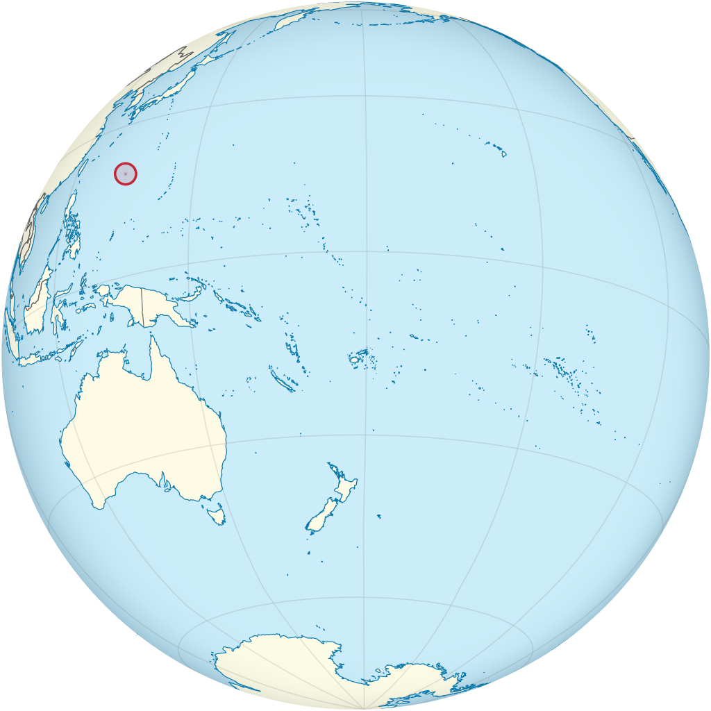
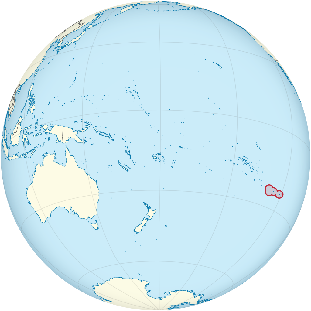
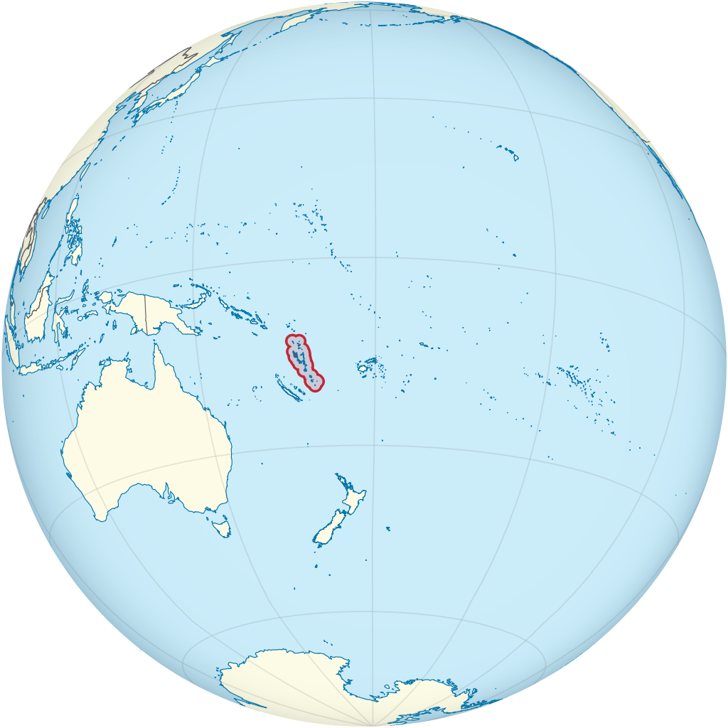
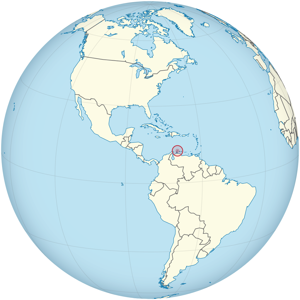
Palmyra Atoll (/pælˈmaɪrə/), also referred to as Palmyra Island, is one of the Northern Line Islands (southeast of Kingman Reef and north of Kiribati). It is located almost due south of the Hawaiian Islands, roughly one-third of the way between Hawaii and American Samoa. North America is about 3,300 miles (5,300 kilometers) northeast and New Zealand the same distance southwest, placing the atoll at the approximate center of the Pacific Ocean. The land area is 4.6 sq mi (12 km2), with about 9 miles (14 km) of sea-facing coastline and reef. There is one boat anchorage known as West Lagoon, accessible from the sea by a narrow artificial channel. It is the second-to-northernmost of the Line Islands, and one of three American islands in the archipelago, along with Jarvis Island and Kingman Reef. Palmyra Atoll is part of the Pacific Remote Islands Marine National Monument, the world's largest marine protected area. The atoll is composed of submerged sand flats along with dry land and reefs. It consists of three lagoons separated by coral reefs. The western reef terrace is one of the biggest shelf-reefs, with dimensions of 2 by 3 miles (3.2 by 4.8 km). Over 150 species of coral inhabit Palmyra Atoll, double the number recorded in Hawaii. (Source: Wikipedia.org, CC BY-SA)
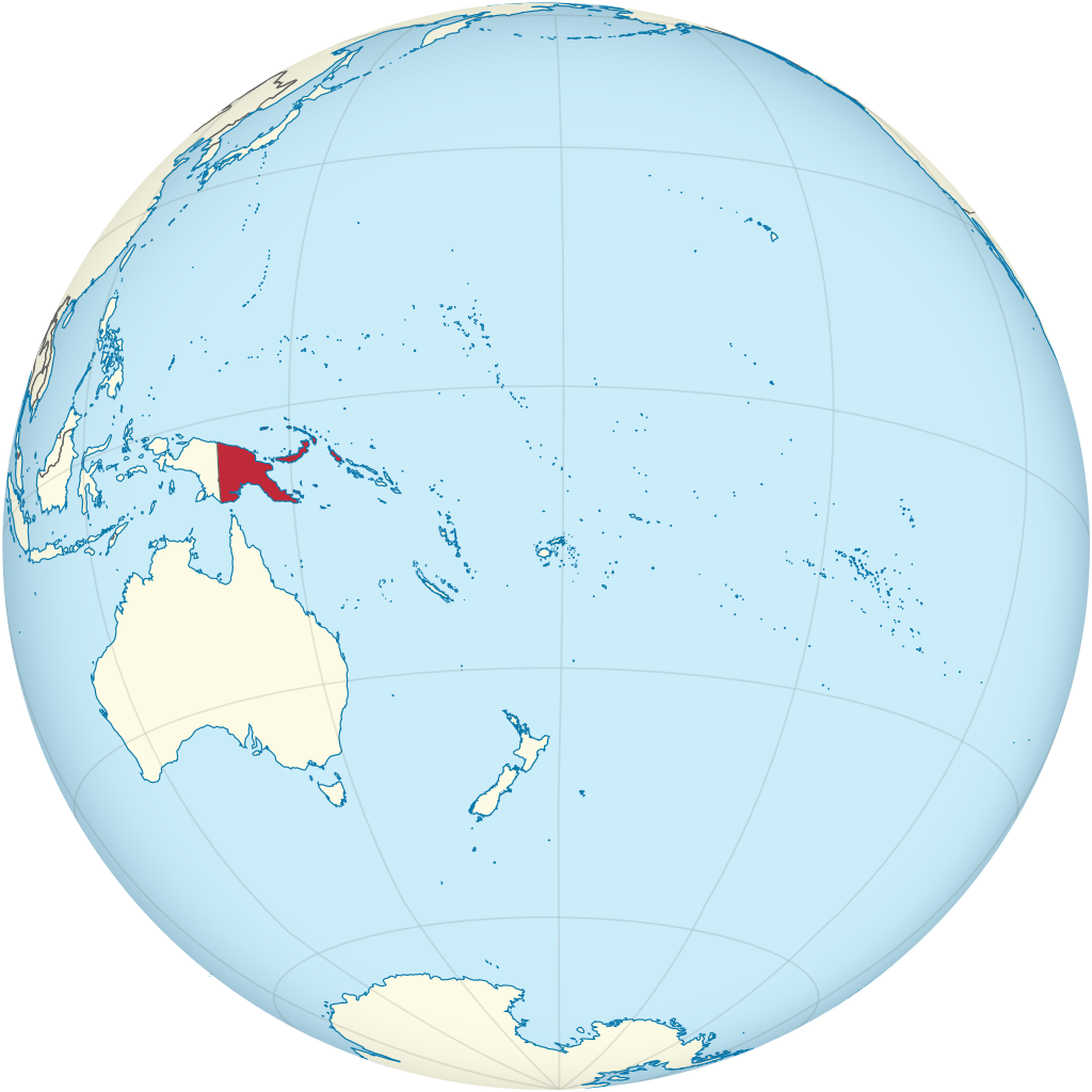
Papua New Guinea (abbreviated PNG; /ˈpæp(j)uə ... ˈɡɪni, ˈpɑː-/, also US: /ˈpɑːpwə-, ˈpɑːpjə-, ˈpɑːpə-/; Tok Pisin: Papua Niugini; Hiri Motu: Papua Niu Gini), officially the Independent State of Papua New Guinea (Tok Pisin: Independen Stet bilong Papua Niugini; Hiri Motu: Independen Stet bilong Papua Niu Gini), is a country in Oceania that comprises the eastern half of the island of New Guinea and its offshore islands in Melanesia (a region of the southwestern Pacific Ocean north of Australia). Its capital, located along its southeastern coast, is Port Moresby. The country is the world's third largest island country, with an area of 462,840 km2 (178,700 sq mi). At the national level, after being ruled by three external powers since 1884, including nearly 60 years of Australian administration starting during World War I, Papua New Guinea established its sovereignty in 1975. It became an independent Commonwealth realm in 1975 with Elizabeth II as its queen. It also became a member of the Commonwealth of Nations in its own right. There are 839 known languages of Papua New Guinea, one of the most linguistically diverse countries in the world. As of 2019, it is also the most rural, as only 13.25% of its people live in urban centres. Most of the population of more than 8,000,000 people live in customary communities. The country is believed to be the home of many undocumented species of plants and animals. (Source: Wikipedia.org, CC BY-SA)
The Pitcairn Islands (/ˈpɪtkɛərn/; Pitkern: Pitkern Ailen), officially the Pitcairn, Henderson, Ducie and Oeno Islands, is a group of four volcanic islands in the southern Pacific Ocean that form the sole British Overseas Territory in the Pacific Ocean. The four islands—Pitcairn, Henderson, Ducie and Oeno—are scattered across several hundred miles of ocean and have a combined land area of about 18 square miles (47 km2). Henderson Island accounts for 86% of the land area, but only Pitcairn Island is inhabited. The islands nearest to the Pitcairn Islands are Mangareva (of French Polynesia) at 688 km to the west and Easter Island at 1,929 km to the east. The Pitcairn Islanders are a biracial ethnic group descended mostly from nine Bounty mutineers and a handful of Tahitian consorts—as is still apparent from the surnames of many of the islanders. The mutiny and its aftermath have been the subject of many books and films. As of January 2020, the territory had only 47 permanent inhabitants. (Source: Wikipedia.org, CC BY-SA)
Samoa, officially the Independent State of Samoa and until 1997 known as Western Samoa, is a Polynesian island country consisting of two main islands (Savai'i and Upolu); two smaller, inhabited islands (Manono and Apolima); and several smaller, uninhabited islands, including the Aleipata Islands (Nu'utele, Nu'ulua, Fanuatapu and Namua). Samoa is located 64 km (40 mi) west of American Samoa, 889 km (552 mi) northeast of Tonga (closest foreign country), 1,152 km (716 mi) northeast of Fiji, 483 km (300 mi) east of Wallis and Futuna, 1,151 km (715 mi) southeast of Tuvalu, 519 km (322 mi) south of Tokelau, 4,190 km (2,600 mi) southwest of Hawaii, and 610 km (380 mi) northwest of Niue. The capital city is Apia. The Lapita people discovered and settled the Samoan Islands around 3,500 years ago. They developed a Samoan language and Samoan cultural identity. Samoa is a unitary parliamentary democracy with 11 administrative divisions. It is a sovereign state and a member of the Commonwealth of Nations. Western Samoa was admitted to the United Nations on 15 December 1976. Because of the Samoans' seafaring skills, pre-20th-century European explorers referred to the entire island group (which includes American Samoa) as the 'Navigator Islands'. The country was a colony of the German Empire from 1899 to 1915, then came under a joint British and New Zealand colonial administration until 1 January 1962, when it became independent. (Source: Wikipedia.org, CC BY-SA)
Solomon Islands is an island country consisting of six major islands and over 900 smaller islands in Oceania, to the east of Papua New Guinea and northwest of Vanuatu. It has a land area of 28,400 square kilometres (11,000 sq mi), and a population of about 700,000. Its capital, Honiara, is located on the largest island, Guadalcanal. The country takes its name from the Solomon Islands archipelago, which is a collection of Melanesian islands that also includes the North Solomon Islands (a part of Papua New Guinea), but excludes outlying islands, such as the Santa Cruz Islands and Rennell and Bellona. The islands have been settled since at least some time between 30,000 and 28,800 BCE, with later waves of migrants, notably the Lapita people, mixing and producing the modern indigenous Solomon Islanders population. In 1568, the Spanish navigator Álvaro de Mendaña was the first European to visit them. Though not named by Mendaña, it is believed that the islands were called 'the Solomons' by those who later received word of his voyage and mapped his discovery. Mendaña returned decades later, in 1595, and another Spanish expedition, led by Portuguese navigator Pedro Fernandes de Queirós, visited the Solomons in 1606. Britain defined its area of interest in the Solomon Islands archipelago in June 1893, when Captain Gibson, R.N., of HMS Curacoa, declared the southern Solomon Islands a British protectorate. During World War II, the Solomon Islands campaign (1942–1945) saw fierce fighting between the United States, British Commonwealth forces and the Empire of Japan, including the Battle of Guadalcanal. (Source: Wikipedia.org, CC BY-SA)
Tokelau (/ˈtoʊkəlaʊ/; lit. 'north-northeast' or 'north wind'; known previously as the Union Islands, and, until 1976, known officially as the Tokelau Islands) is a dependent territory of New Zealand in the southern Pacific Ocean. It consists of three tropical coral atolls: Atafu, Nukunonu, and Fakaofo. They have a combined land area of 10 km2 (4 sq mi). The capital rotates yearly among the three atolls. In addition to these three, Swains Island, which forms part of the same archipelago, is the subject of an ongoing territorial dispute; it is currently administered by the United States as part of American Samoa. Tokelau lies north of the Samoan Islands, east of Tuvalu, south of the Phoenix Islands, southwest of the more distant Line Islands, and northwest of the Cook Islands. Tokelau has a population of approximately 1,500 people; it has the fourth-smallest population of any sovereign state or dependency in the world. As of the 2016 census, around 45% of its residents had been born overseas, mostly in Samoa or New Zealand. The populace has a life expectancy of 69, which is comparable to that of other Oceanian island nations. Approximately 94% of the population speak Tokelauan as their first language. Tokelau has the smallest economy of any sovereign nation, although it is a leader in renewable energy, being the first 100% solar-powered nation in the world. (Source: Wikipedia.org, CC BY-SA)
Tonga (/ˈtɒŋɡə/, /ˈtɒŋə/; Tongan: [ˈtoŋa]), officially the Kingdom of Tonga (Tongan: Puleʻanga Fakatuʻi ʻo Tonga), is a Polynesian country and archipelago. The country has 171 islands – of which 45 are inhabited. Its total surface area is about 750 km2 (290 sq mi), scattered over 700,000 km2 (270,000 sq mi) in the southern Pacific Ocean. As of 2021, according to Johnson's Tribune, Tonga has a population of 104,494, 70% of whom reside on the main island, Tongatapu. The country stretches approximately 800 km (500 mi) north-south. It is surrounded by Fiji and Wallis and Futuna (France) to the northwest; Samoa to the northeast; New Caledonia (France) and Vanuatu to the west; Niue (the nearest foreign territory) to the east; and Kermadec (New Zealand) to the southwest. Tonga is about 1,800 km (1,100 mi) from New Zealand's North Island. First inhabited roughly 2,500 years ago by the Lapita civilization, Tonga's Polynesian settlers gradually evolved a distinct and strong ethnic identity, language, and culture as the Tongan people. They were quick to establish a powerful footing across the South Pacific, and this period of Tongan expansionism and colonization is known as the Tuʻi Tonga Empire. From the rule of the first Tongan king, ʻAhoʻeitu, Tonga grew into a regional power. It was a thalassocracy that conquered and controlled unprecedented swathes of the Pacific, from parts of the Solomon Islands and the whole of New Caledonia and Fiji in the west to Samoa and Niue and even as far as parts of modern-day French Polynesia in the east. Tuʻi Tonga became renowned for its economic, ethnic, and cultural influence over the Pacific, which remained strong even after the Samoan revolution of the 13th century and Europeans' discovery of the islands in 1616. (Source: Wikipedia.org, CC BY-SA)
Tuvalu (/tuːˈvɑːluː/ too-VAH-loo or /ˈtuːvəluː/ TOO-və-loo; formerly known as the Ellice Islands) is an island country and microstate in the Polynesian subregion of Oceania in the Pacific Ocean. Its islands are situated about midway between Hawaii and Australia. They lie east-northeast of the Santa Cruz Islands (which belong to the Solomon Islands), northeast of Vanuatu, southeast of Nauru, south of Kiribati, west of Tokelau, northwest of Samoa and Wallis and Futuna, and north of Fiji. Tuvalu is composed of three reef islands and six atolls. They are spread out between the latitude of 5° and 10° south and between the longitude of 176° and 180°. They lie west of the International Date Line. Tuvalu has a population of 10,507 (2017 census). The total land area of the islands of Tuvalu is 26 square kilometres (10 sq mi). The first inhabitants of Tuvalu were Polynesians, according to well-established theories regarding a migration of Polynesians into the Pacific that began about three thousand years ago. Long before European contact with the Pacific islands, Polynesians frequently voyaged by canoe between the islands. Polynesian navigation skills enabled them to make elaborately planned journeys in either double-hulled sailing canoes or outrigger canoes. Scholars believe that the Polynesians spread out from Samoa and Tonga into the Tuvaluan atolls, which then served as a stepping stone for further migration into the Polynesian outliers in Melanesia and Micronesia. (Source: Wikipedia.org, CC BY-SA)
Vanuatu (English: /ˌvɑːnuˈɑːtuː/ VAH-noo-AH-too or /vænˈwɑːtuː/ van-WAH-too; Bislama and French pronunciation [vanuatu]), officially the Republic of Vanuatu (French: République de Vanuatu; Bislama: Ripablik blong Vanuatu), is an island country located in the South Pacific Ocean. The archipelago, which is of volcanic origin, is 1,750 km (1,090 mi) east of northern Australia, 540 km (340 mi) northeast of New Caledonia, east of New Guinea, southeast of the Solomon Islands, and west of Fiji. Vanuatu was first inhabited by Melanesian people. The first Europeans to visit the islands were a Spanish expedition led by Portuguese navigator Fernandes de Queirós, who arrived on the largest island, Espíritu Santo, in 1606. Queirós claimed the archipelago for Spain, as part of the colonial Spanish East Indies, and named it La Austrialia del Espíritu Santo. In the 1880s, France and the United Kingdom claimed parts of the archipelago, and in 1906, they agreed on a framework for jointly managing the archipelago as the New Hebrides through an Anglo-French condominium. An independence movement arose in the 1970s, and the Republic of Vanuatu was founded in 1980. Since independence, the country has become a member of the United Nations, Commonwealth of Nations, Organisation internationale de la Francophonie and the Pacific Islands Forum. (Source: Wikipedia.org, CC BY-SA)
Wake Island (Marshallese: Ānen Kio, lit. 'island of the kio flower'; also known as Wake Atoll) is a coral atoll in the western Pacific Ocean in the northeastern area of the Micronesia subregion, 1,501 miles (2,416 kilometers) east of Guam, 2,298 miles (3,698 kilometers) west of Honolulu, 1,991 miles (3,204 kilometers) southeast of Tokyo and 898 miles (1,445 kilometers) north of Majuro. The island is an unorganized, unincorporated territory belonging to (but not a part of) the United States that is also claimed by the Republic of the Marshall Islands. Wake Island is one of the most isolated islands in the world. The nearest inhabited island is Utirik Atoll in the Marshall Islands, 592 miles (953 kilometers) to the southeast. The United States took possession of Wake Island in 1899. One of 14 U.S. insular areas, Wake Island is administered by the United States Air Force under an agreement with the U.S. Department of the Interior. The center of activity on the atoll is at Wake Island Airfield, which is primarily used as a mid-Pacific refueling stop for military aircraft and as an emergency landing area. The 9,800-foot (3,000 m) runway is the longest strategic runway in the Pacific islands. South of the runway is the Wake Island Launch Center, a missile launch site. The island has no permanent inhabitants, but approximately 100 people live there at any given time. (Source: Wikipedia.org, CC BY-SA)
Wallis and Futuna, officially the Territory of the Wallis and Futuna Islands (/ˈwɒlɪs ... fuːˈtuːnə/; French: Wallis-et-Futuna [walis e futuna] or Territoire des îles Wallis-et-Futuna, Fakauvea and Fakafutuna: ʻUvea mo Futuna), is a French island collectivity in the South Pacific, situated between Tuvalu to the northwest, Fiji to the southwest, Tonga to the southeast, Samoa to the east, and Tokelau to the northeast. Mata Utu is its capital and largest city. Its land area is 142.42 km2 (54.99 sq mi). It had a population of 11,558 at the 2018 census (down from 14,944 at the 2003 census). The territory is made up of three main volcanic tropical islands and a number of tiny islets. It is divided into two island groups that lie about 260 km (160 mi) apart: the Wallis Islands (also known as Uvea) in the northeast; and the Hoorn Islands (also known as the Futuna Islands) in the southwest, including Futuna Island proper and the mostly uninhabited Alofi Island. Since 28 March 2003, Wallis and Futuna has been a French overseas collectivity (collectivité d'outre-mer, or COM). Between 1961 and 2003, it had the status of a French overseas territory (territoire d'outre-mer, or TOM). Its official name did not change when its status changed. (Source: Wikipedia.org, CC BY-SA)
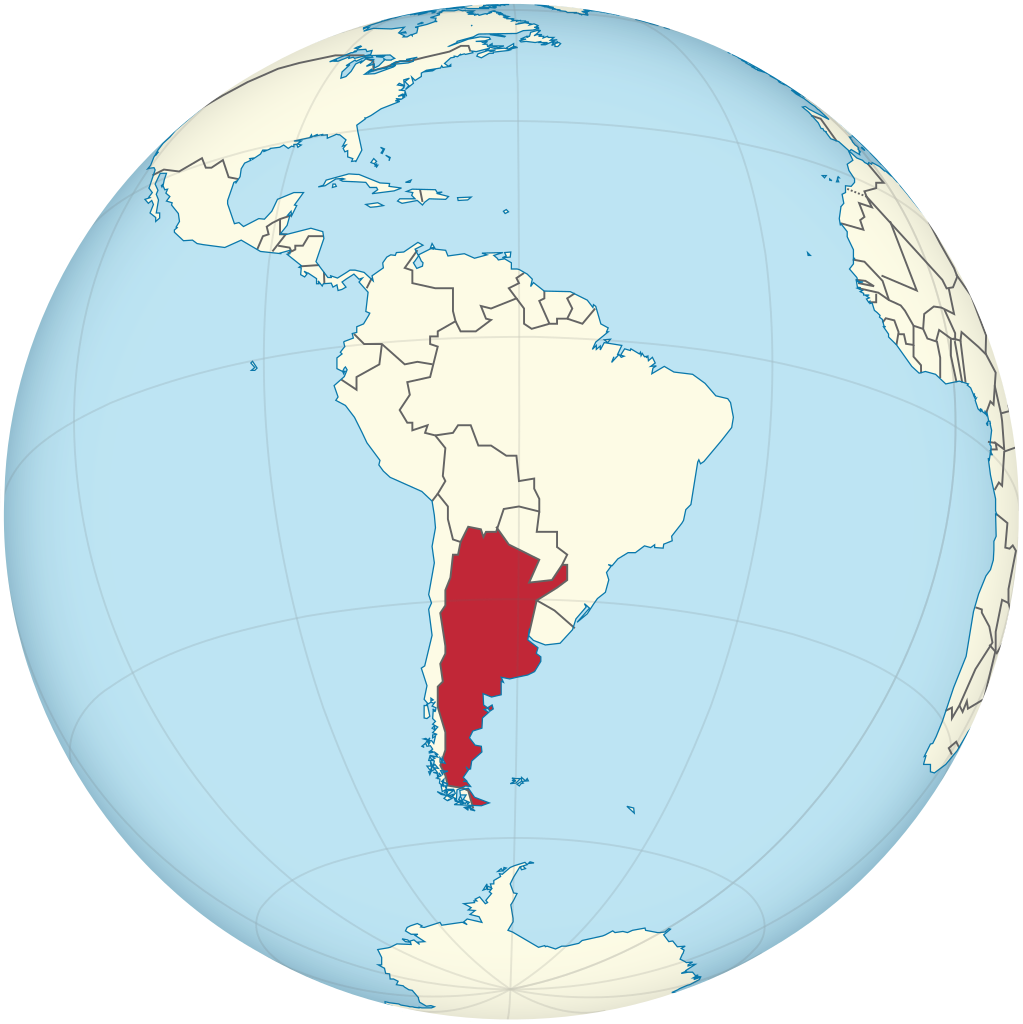
Argentina (Spanish pronunciation: [aɾxenˈtina] ), officially the Argentine Republic (Spanish: República Argentina), is a country in the southern half of South America. Argentina covers an area of 2,780,400 km2 (1,073,500 sq mi), making it the second-largest country in South America after Brazil, the fourth-largest country in the Americas, and the eighth-largest country in the world. It shares the bulk of the Southern Cone with Chile to the west, and is also bordered by Bolivia and Paraguay to the north, Brazil to the northeast, Uruguay and the South Atlantic Ocean to the east, and the Drake Passage to the south. Argentina is a federal state subdivided into twenty-three provinces, and one autonomous city, which is the federal capital and largest city of the nation, Buenos Aires. The provinces and the capital have their own constitutions, but exist under a federal system. Argentina claims sovereignty over the Falkland Islands, South Georgia and the South Sandwich Islands, and a part of Antarctica. (Source: Wikipedia.org, CC BY-SA)
Aruba (/əˈruːbə/ ə-ROO-bə, Dutch: [aːˈrubaː, -ryb-] , Papiamento: [aˈruba]), officially the Country of Aruba (Dutch: Land Aruba; Papiamento: Pais Aruba) is a constituent country of the Kingdom of the Netherlands physically located in the mid-south of the Caribbean Sea, about 29 kilometres (18 mi) north of the Venezuelan peninsula of Paraguaná and 80 kilometres (50 mi) northwest of Curaçao. It measures 32 kilometres (20 mi) long from its northwestern to its southeastern end and 10 kilometres (6 mi) across at its widest point. Together with Bonaire and Curaçao, Aruba forms a group referred to as the ABC islands. Collectively, these and the other three Dutch substantial islands in the Caribbean are often called the Dutch Caribbean, of which Aruba has about one-third of the population. In 1986, it became a constituent country within the Kingdom of the Netherlands, and acquired the formal name the Country of Aruba. Aruba is one of the four countries that form the Kingdom of the Netherlands, along with the Netherlands, Curaçao, and Sint Maarten; the citizens of these countries are all Dutch nationals. Aruba has no administrative subdivisions, but, for census purposes, is divided into eight regions. Its capital is Oranjestad. (Source: Wikipedia.org, CC BY-SA)
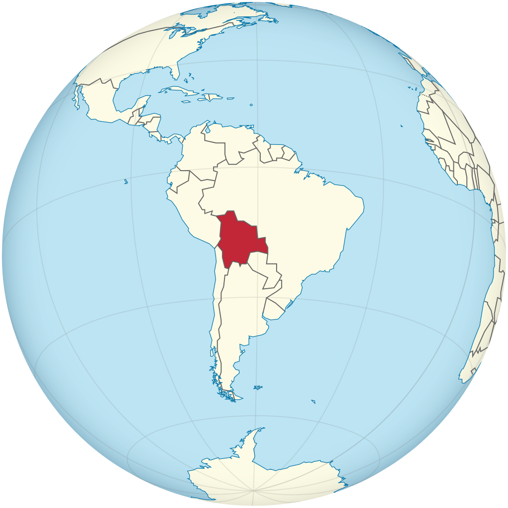
Bolivia, officially the Plurinational State of Bolivia, is a landlocked country located in western-central South America. It is bordered by Brazil to the north and east, Paraguay to the southeast, Argentina to the south, Chile to the southwest and Peru to the west. The seat of government and executive capital is La Paz, while the constitutional capital is Sucre. The largest city and principal industrial center is Santa Cruz de la Sierra, located on the Llanos Orientales (tropical lowlands), a mostly flat region in the east of the country. The sovereign state of Bolivia is a constitutionally unitary state, divided into nine departments. Its geography varies from the peaks of the Andes in the West, to the Eastern Lowlands, situated within the Amazon basin. One-third of the country is within the Andean mountain range. With 1,098,581 km2 (424,164 sq mi) of area, Bolivia is the fifth largest country in South America, after Brazil, Argentina, Peru, and Colombia (and alongside Paraguay, one of the only two landlocked countries in the Americas), the 27th largest in the world, the largest landlocked country in the Southern Hemisphere, and the world's seventh largest landlocked country, after Kazakhstan, Mongolia, Chad, Niger, Mali, and Ethiopia. (Source: Wikipedia.org, CC BY-SA)
Bonaire (/bɒnˈɛər/; Dutch: Bonaire, pronounced [boːˈnɛːr(ə)] ; Papiamento: Boneiru, [buˈneiru], almost pronounced [boˈnɛiru]) is a Dutch island in the Leeward Antilles in the Caribbean Sea. Its capital is the port of Kralendijk, on the west (leeward) coast of the island. Aruba, Bonaire and Curaçao form the ABC islands, 80 km (50 miles) off the coast of Venezuela. Unlike much of the Caribbean region, the ABC islands lie outside Hurricane Alley. The islands have an arid climate that attracts visitors seeking warm, sunny weather all year round. Bonaire is a popular snorkeling and scuba diving destination because of its multiple shore diving sites and easy access to the island's fringing reefs. As of 1 January 2019, the island's population totaled 20,104 permanent residents, an increase of about 1,200 since 2015. The island's total land area is 288 square kilometres (111 sq mi); it is 38.6 kilometres (24.0 mi) long from north to south, and ranges from 4.8–8 km (3.0–5.0 mi) wide from east to west. A short 800 metres (0.50 mi) west of Bonaire across the sea is the uninhabited islet Klein Bonaire with a total land area of 6 km2 (2.3 sq mi). Klein Bonaire has low-growing vegetation including cactus (Papiamento: kadushi), with sparse palm trees near the water and is bordered by white sandy beaches and a fringing reef. The reefs, beaches and on-island reserves located on both Bonaire and Klein Bonaire are under the protection of the Bonaire National Marine Park, and managed by Stichting Nationale Parken Bonaire (STINAPA). (Source: Wikipedia.org, CC BY-SA)
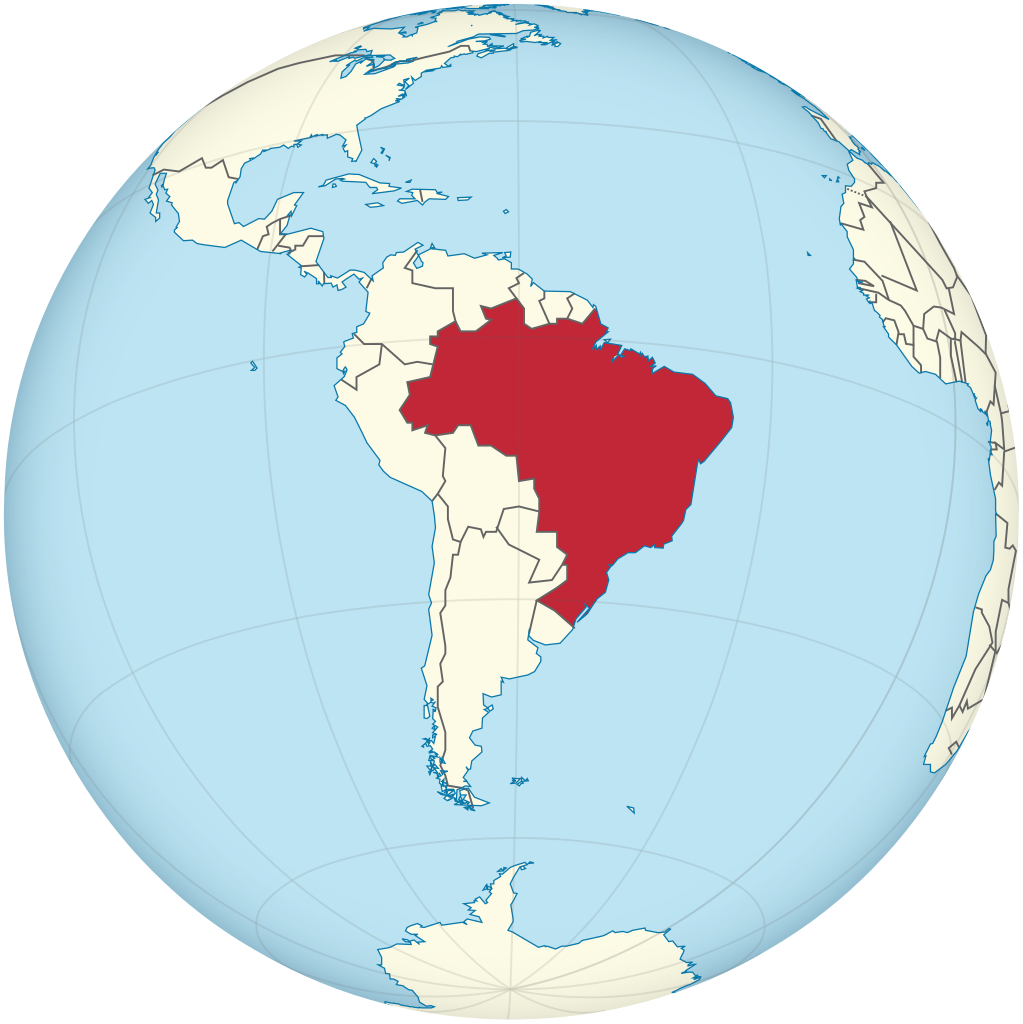
Brazil (Portuguese: Brasil; Brazilian Portuguese: [bɾaˈziw]),[nt 1] officially the Federative Republic of Brazil (Portuguese: República Federativa do Brasil), is the largest country in both South America and Latin America. At 8.5 million square kilometers (3,300,000 sq mi) and with over 217 million people, Brazil is the world's fifth-largest country by area and the seventh most populous. Its capital is Brasília, and its most populous city is São Paulo. The federation is composed of the union of the 26 states and the Federal District. It is the largest country to have Portuguese as an official language and the only one in the Americas; one of the most multicultural and ethnically diverse nations, due to over a century of mass immigration from around the world; and the most populous Roman Catholic-majority country. Bounded by the Atlantic Ocean on the east, Brazil has a coastline of 7,491 kilometers (4,655 mi). It borders all other countries and territories in South America except Ecuador and Chile and covers roughly half of the continent's land area. Its Amazon basin includes a vast tropical forest, home to diverse wildlife, a variety of ecological systems, and extensive natural resources spanning numerous protected habitats. This unique environmental heritage positions Brazil at number one of 17 megadiverse countries, and is the subject of significant global interest, as environmental degradation through processes like deforestation has direct impacts on global issues like climate change and biodiversity loss. (Source: Wikipedia.org, CC BY-SA)
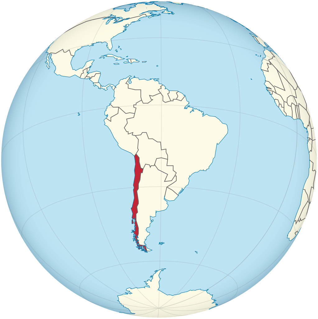
Chile, officially the Republic of Chile, is a country in the western part of South America. It is the southernmost country in the world, and the closest to Antarctica, occupying a long and narrow strip of land between the Andes to the east and the Pacific Ocean to the west. Chile covers an area of 756,096 square kilometers (291,930 sq mi), with a population of 17.5 million as of 2017. It shares land borders with Peru to the north, Bolivia to the north-east, Argentina to the east, and the Drake Passage in the far south. Chile also controls the Pacific islands of Juan Fernández, Isla Salas y Gómez, Desventuradas, and Easter Island in Oceania. It also claims about 1,250,000 square kilometers (480,000 sq mi) of Antarctica under the Chilean Antarctic Territory. The country's capital and largest city is Santiago, and its national language is Spanish. Chile is a developing country with a high-income economy and ranks 42nd in the Human Development Index. It is among the most economically and socially stable nations in South America, leading Latin America in rankings of competitiveness, per capita income, globalization, state of peace, and economic freedom. Chile also ranks high regionally in sustainability of the state, democratic development, and has the lowest homicide rate in the Americas after Canada. It is a founding member of the United Nations, the Community of Latin American and Caribbean States (CELAC) and the Pacific Alliance, and joined the OECD in 2010. (Source: Wikipedia.org, CC BY-SA)
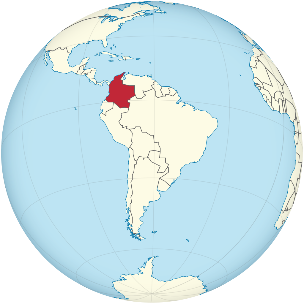
Colombia (/kəˈlʌmbiə/ , /-ˈlɒm-/; Spanish: [koˈlombja] ), officially the Republic of Colombia, is a country in South America with an insular region in North America. It is bordered by the Caribbean Sea to the north, Venezuela to the east, Brazil to the southeast, Ecuador and Peru to the south, the Pacific Ocean to the west and Panama to the northwest. Colombia comprises 32 departments and the Capital District of Bogotá, the country's largest city. It covers an area of 1,141,748 square kilometers (440,831 sq mi), with a population of 50 million. Colombia's cultural heritage reflects influences by various Amerindian civilizations, European settlement, enslaved Africans, as well as immigration from Europe and the Middle East. Spanish is the nation's official language, besides which over 70 languages are spoken. Colombia has been inhabited by various indigenous peoples since at least 12,000 BCE, including the Muisca, Quimbaya and Tairona. The Spanish landed first in La Guajira in 1499 and by the mid-16th century colonized parts of the region, establishing the New Kingdom of Granada, with Santa Fé de Bogotá as its capital. Independence from the Spanish Empire was achieved in 1819, with what is now Colombia emerging as the United Provinces of New Granada. The new nation experimented with federalism as the Granadine Confederation (1858) and then the United States of Colombia (1863), before the Republic of Colombia was finally declared in 1886. Panama seceded in 1903, leading to Colombia's present borders. Beginning in the 1960s, the country has suffered from an asymmetric low-intensity armed conflict and political violence, both of which escalated in the 1990s. Since 2005, there has been significant improvement in security, stability and rule of law, as well as unprecedented economic growth and development. (Source: Wikipedia.org, CC BY-SA)
Curaçao (/ˈkjʊərəsoʊ, -saʊ, ˌkjʊərəˈsoʊ, -ˈsaʊ/ KYURE-əss-oh, -ow, -OH, -OW; Dutch: [kyːraːˈsʌu, kuːr-] ; Papiamento: Kòrsou, [ˈkɔrsɔu̯]), officially the Country of Curaçao (Dutch: Land Curaçao; Papiamento: Pais Kòrsou), is a Lesser Antilles island country in the southern Caribbean Sea and the Dutch Caribbean region, about 65 km (40 mi) north of the Venezuelan coast. It is a colony of the Kingdom of the Netherlands. Together with Aruba and Bonaire, it forms the ABC islands. Collectively, Curaçao, Aruba, and other Dutch islands in the Caribbean are often called the Dutch Caribbean. Curaçao was formerly part of the Curaçao and Dependencies colony from 1815 to 1954 and later the Netherlands Antilles from 1954 to 2010, as Island Territory of Curaçao (Dutch: Eilandgebied Curaçao, Papiamento: Teritorio Insular di Kòrsou), and is now formally called the Country of Curaçao. It includes the main island of Curaçao and the much smaller, uninhabited island of Klein Curaçao ('Little Curaçao'). Curaçao has a population of 158,665 (January 2019 est.), with an area of 444 km2 (171 sq mi); its capital is Willemstad. (Source: Wikipedia.org, CC BY-SA)
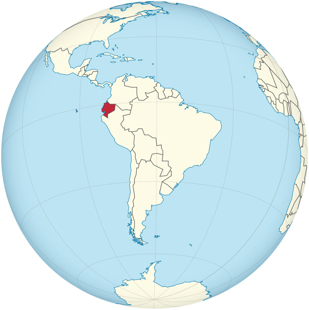
Ecuador (/ˈɛkwədɔːr/ EK-wə-dor; Spanish pronunciation: [ekwaˈðoɾ] ; Quechua: Ikwayur; Shuar: Ecuador or Ekuatur), officially the Republic of Ecuador (Spanish: República del Ecuador, which literally translates as 'Republic of the Equator'; Quechua: Ikwadur Ripuwlika; Shuar: Ekuatur Nunka), is a country in northwestern South America, bordered by Colombia on the north, Peru on the east and south, and the Pacific Ocean on the west. Ecuador also includes the Galápagos Islands in the Pacific, about 1,000 kilometers (621 mi) west of the mainland. The country's capital and largest city is Quito. The territories of modern-day Ecuador were once home to a variety of Indigenous groups that were gradually incorporated into the Inca Empire during the 15th century. The territory was colonized by Spain during the 16th century, achieving independence in 1820 as part of Gran Colombia, from which it emerged as its own sovereign state in 1830. The legacy of both empires is reflected in Ecuador's ethnically diverse population, with most of its 17.8 million people being mestizos, followed by large minorities of Europeans, Native American, and African descendants. Spanish is the official language and is spoken by a majority of the population, though 13 Native languages are also recognized, including Quechua and Shuar. (Source: Wikipedia.org, CC BY-SA)
The Falkland Islands (/ˈfɔːklənd, ˈfɔːl-, ˈfɒl-/; Spanish: Islas Malvinas) is an archipelago in the South Atlantic Ocean on the Patagonian Shelf. The principal islands are about 300 mi (480 km) east of South America's southern Patagonian coast and about 752 mi (1,210 km) from Cape Dubouzet at the northern tip of the Antarctic Peninsula, at a latitude of about 52°S. The archipelago, with an area of 4,700 sq mi (12,000 km2), comprises East Falkland, West Falkland, and 776 smaller islands. As a British overseas territory, the Falklands have internal self-governance, but the United Kingdom takes responsibility for their defence and foreign affairs. The capital and largest settlement is Stanley on East Falkland. Controversy exists over the Falklands' discovery and subsequent colonisation by Europeans. At various times, the islands have had French, British, Spanish, and Argentine settlements. Britain reasserted its rule in 1833, but Argentina maintains its claim to the islands. In April 1982, Argentine military forces invaded the islands. British administration was restored two months later at the end of the Falklands War. In a 2013 sovereignty referendum, almost all Falklanders voted in favour of the archipelago remaining a UK overseas territory. The territory's sovereignty status is part of an ongoing dispute between Argentina and the United Kingdom. (Source: Wikipedia.org, CC BY-SA)
French Guiana (/ɡiˈɑːnə/ or /ɡiˈænə/; French: Guyane [ɡɥijan] ; French Guianese Creole: Lagwiyann) is an overseas department/region and single territorial collectivity of France on the northern Atlantic coast of South America in the Guianas. It borders Brazil to the east and south and Suriname to the west. With a land area of 83,534 km2 (32,253 sq mi), French Guiana is the second-largest region of France (more than one-seventh the size of Metropolitan France) and the largest outermost region within the European Union. It has a very low population density, with only 3.5 inhabitants per square kilometre (9.1/sq mi). (Its population is less than 1⁄200 that of Metropolitan France.) Half of its 294,436 inhabitants in 2022 lived in the metropolitan area of Cayenne, its capital. 98.9% of the land territory of French Guiana is covered by forests, a large part of which is primeval rainforest. The Guiana Amazonian Park, which is the largest national park in the European Union, covers 41% of French Guiana's territory. (Source: Wikipedia.org, CC BY-SA)
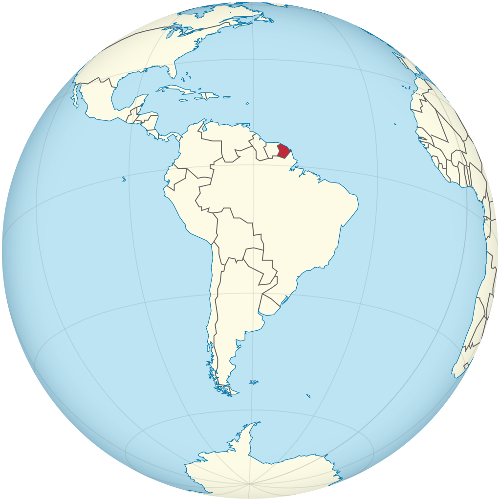
Guyana (/ɡaɪˈɑːnə/ or /ɡaɪˈænə/ ), officially the Co‑operative Republic of Guyana, is a country on the northern mainland of South America. Guyana is an indigenous word which means 'Land of Many Waters'. The capital city is Georgetown. Guyana is bordered by the Atlantic Ocean to the north, Brazil to the south and southwest, Venezuela to the west, and Suriname to the east. With 215,000 km2 (83,000 sq mi), Guyana is the third-smallest sovereign state by area in mainland South America after Uruguay and Suriname, and is the second-least populous sovereign state in South America after Suriname; it is also one of the least densely populated countries on Earth. It has a wide variety of natural habitats and very high biodiversity. The region known as 'the Guianas' consists of the large shield landmass north of the Amazon River and east of the Orinoco River known as the 'land of many waters'. Nine indigenous tribes reside in Guyana: the Wai Wai, Macushi, Patamona, Lokono, Kalina, Wapishana, Pemon, Akawaio and Warao. Historically dominated by the Lokono and Kalina tribes, Guyana was colonised by the Dutch before coming under British control in the late 18th century. It was governed as British Guiana, with a mostly plantation-style economy until the 1950s. It gained independence in 1966, and officially became a republic within the Commonwealth of Nations in 1970. The legacy of British rule is reflected in the country's political administration and diverse population, which includes Indian, African, Indigenous, Chinese, Portuguese, other European, and various multiracial groups. In 2017, 41% of the population of Guyana lived below the poverty line. (Source: Wikipedia.org, CC BY-SA)
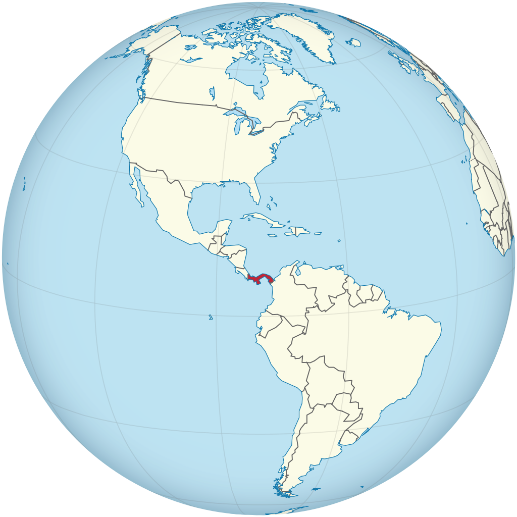
Panama (/ˈpænəmɑː/ PAN-ə-mah, /pænəˈmɑː/ pan-ə-MAH; Spanish: Panamá IPA: [panaˈma] ), officially the Republic of Panama (Spanish: República de Panamá), is a transcontinental country spanning the central part of North America and the northern part of South America. It is bordered by Costa Rica to the west, Colombia to the southeast, the Caribbean Sea to the north, and the Pacific Ocean to the south. Its capital and largest city is Panama City, whose metropolitan area is home to nearly half the country's 4 million people. Panama was inhabited by indigenous tribes before Spanish colonists arrived in the 16th century. It broke away from Spain in 1821 and joined the Republic of Gran Colombia, a union of Nueva Granada, Ecuador, and Venezuela. After Gran Colombia dissolved in 1831, Panama and Nueva Granada eventually became the Republic of Colombia. With the backing of the United States, Panama seceded from Colombia in 1903, allowing the construction of the Panama Canal to be completed by the United States Army Corps of Engineers between 1904 and 1914. The 1977 Torrijos–Carter Treaties agreed to transfer the canal from the United States to Panama on December 31, 1999. The surrounding territory was first returned in 1979. (Source: Wikipedia.org, CC BY-SA)
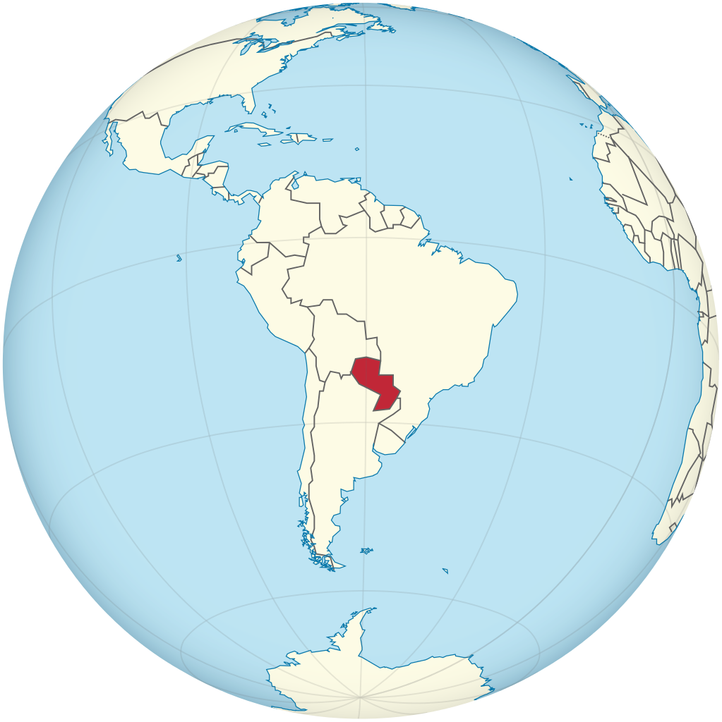
Paraguay (/ˈpærəɡwaɪ/; Spanish pronunciation: [paɾaˈɣwaj] ), officially the Republic of Paraguay (Spanish: República del Paraguay; Guarani: Tavakuairetã Paraguái), is a landlocked country in South America. It is bordered by Argentina to the south and southwest, Brazil to the east and northeast, and Bolivia to the northwest. It has a population of seven million, nearly three million of whom live in the capital and largest city of Asunción, and its surrounding metro. Although one of only two landlocked countries in South America (Bolivia is the other), Paraguay has ports on the Paraguay and Paraná rivers that give exit to the Atlantic Ocean, through the Paraná-Paraguay Waterway. The majority of Paraguay's seven million people are mestizo, and Guarani culture remains widely influential; more than 90% of the population speak various dialects of the Guarani language alongside Spanish. Despite a history of poverty and political repression, in a 2017 Positive Experience Index based on global polling data, Paraguay ranked as the 'world's happiest place'. (Source: Wikipedia.org, CC BY-SA)
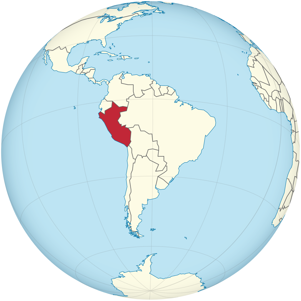
Peru (/pəˈruː/ ; Spanish: Perú [peˈɾu]; Quechua: Piruw [pɪɾʊw]; Aymara: Piruw [pɪɾʊw]), officially the Republic of Peru (Spanish: República del Perú (help·info)), is a country in western South America. It is bordered in the north by Ecuador and Colombia, in the east by Brazil, in the southeast by Bolivia, in the south by Chile, and in the south and west by the Pacific Ocean. Peru is a megadiverse country with habitats ranging from the arid plains of the Pacific coastal region in the west to the peaks of the Andes mountains extending from the north to the southeast of the country to the tropical Amazon basin rainforest in the east with the Amazon River. Peru has a population of 32 million, and its capital and largest city is Lima. At 1.28 million km2 (0.5 million mi2), Peru is the 19th largest country in the world, and the third largest in South America. Peruvian territory was home to several cultures during the ancient and medieval periods, and has one of the longest histories of civilization of any country, tracing its heritage back to the 10th millennium BCE. Notable pre-colonial cultures and civilizations include the Caral-Supe civilization (the earliest civilization in the Americas and considered one of the cradles of civilization,) the Nazca culture, the Wari and Tiwanaku empires, the Kingdom of Cusco, and the Inca Empire, the largest known state in the pre-Columbian Americas. (Source: Wikipedia.org, CC BY-SA)

Help us promote traffic rules on the internet, together we can make the public road safer for everyone. Post a comment or share on social media!
Most problems are a result of higher than safe driving speeds. Please just slow down and be patient.
 0
0
Question 121: Poor translation: Vehicles with polluted fluids prohibited Should be translated as: Vehicles with dangerous liquids prohibited
1
Question 83: Poor translation: Vehicles with polluted fluids prohibited Should be translated as: Vehicles with dangerous liquids prohibited
0
Want even more practice? Visit similar websites offering realistic practice driving knowledge tests. Visit us to see what sets our tests apart! https://dkttest.com/capital-territory/
0
Cool tool! And fun to check whether I remember the rules :) Two things I noticed: Warning for a crossroad side roads on the left and right. While technically that might be the correct translation, this sign tells you, that you are on the main road and have the right of way for the next crossroad and only the next crossroad. Usually (if no sign specifies otherwise) you have to give way to drivers coming from the right at every intersection, which can get a bit annoying in communal areas, so seeing this sign feels less like a warning and more like relief :). A Fahrradstraße is not a lane for cyclists but a street for cyclists, meaning the (whole!) street is intended predominantly for cyclists, who are then allowed to ride next to each other. Cars are allowed to drive there (unless another sign prohibits such), but have to adjust their speed to the cyclists. I believe they are not allowed to pass at all, even if the oncoming lane is empty.
0
this website is a simpy website i love this its fat and im in my mums basement rn help sui u r a mothr fker
3
Hi i am such fat fan of this great gaming website. Im so hangry for the cause mate! Liking the simps eating on yall tho nott gonna lie to ya!
0
The system is now changed and they use some type of tablet for the exam now. Do anyone have the questions which they ask in the tablet because the questions are different. I still didn’t pass my provisional driving knowledge test. It would be great if someone could help
0
Good exercise !! Looking for some drift friends, hit to my email Funnyparts@gmail.com
The exercise of the activity of TVDE driver, without it being registered on an electronic platform, incurs:
0
Who will be responsible for infractions that may be committed and for damages caused to third parties, without prejudice to the corresponding administrative sanctions:
0
This answer is incorrect. What does this traffic sign mean? Square sign with a circular not parking inside. Choices: Begin of a zone where parking is allowed, Being of a zone with a speed limit, Begin of zone where parking is prohibited, Begin of a residential area. The correct answer should be Begin of a zone where parking is allowed NOT Begin of zone where parking is prohibited. It is a Controlled parking Zone.
0


More community