

Here you can study for the exam. Look up keywords and learn definitions about all kind of subjects.
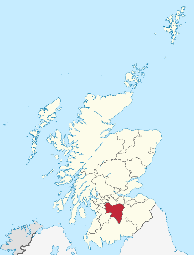
North Lanarkshire (Scots: North Lanrikshire; Scottish Gaelic: Siorrachd Lannraig a Tuath) is one of 32 council areas of Scotland. It borders the north-east of the City of Glasgow and contains many of Glasgow's suburbs and commuter towns and villages. It also borders East Dunbartonshire, Falkirk, Stirling, South Lanarkshire and West Lothian. The council area covers parts of the historic counties of Dunbartonshire, Lanarkshire and Stirlingshire. The council is based in Motherwell. The area was formed in 1996 covering the districts of Cumbernauld and Kilsyth, Motherwell, and Monklands, plus the Chryston and Auchinloch area from Strathkelvin district, all of which had been in Strathclyde region between 1975 and 1996. As a new single-tier authority, North Lanarkshire became responsible for all functions previously performed by both the regional council and the district councils, which were abolished. (Source: Wikipedia.org, CC BY-SA)
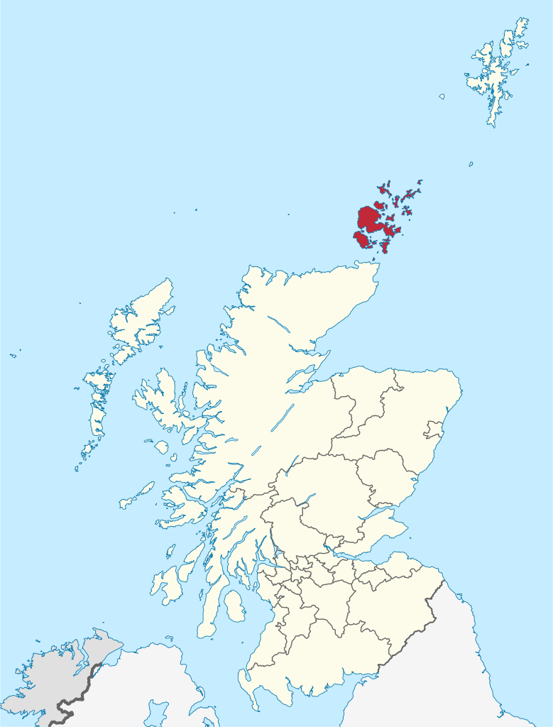
Orkney (/ˈɔːrkni/; Scots: Orkney; Old Norse: Orkneyjar; Norn: Orknøjar), also known as the Orkney Islands or The Orkneys, is an archipelago in the Northern Isles of Scotland, situated off the north coast of the island of Great Britain. Orkney is 10 miles (16 km) north of the coast of Caithness and has about 70 islands, of which 20 are inhabited. The largest island, the Mainland, has an area of 523 square kilometres (202 sq mi), making it the sixth-largest Scottish island and the tenth-largest island in the British Isles. Orkney's largest settlement, and also its administrative centre, is Kirkwall. (Source: Wikipedia.org, CC BY-SA)
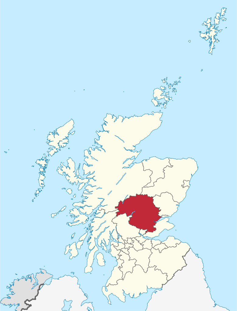
Perth and Kinross (Scots: Pairth an Kinross; Scottish Gaelic: Peairt agus Ceann Rois) is one of the 32 council areas of Scotland and a lieutenancy area. It borders onto the Aberdeenshire, Angus, Argyll and Bute, Clackmannanshire, Dundee, Fife, Highland and Stirling council areas. Perth is the administrative centre. With the exception of a large area of south-western Perthshire, the council area mostly corresponds to the historic counties of Perthshire and Kinross-shire. Geographically the area is split by the Highland Boundary Fault into a more mountainous northern part and a flatter southern part. The northern area is a popular tourist spot, while agriculture makes an important contribution to the southern part of the area. (Source: Wikipedia.org, CC BY-SA)
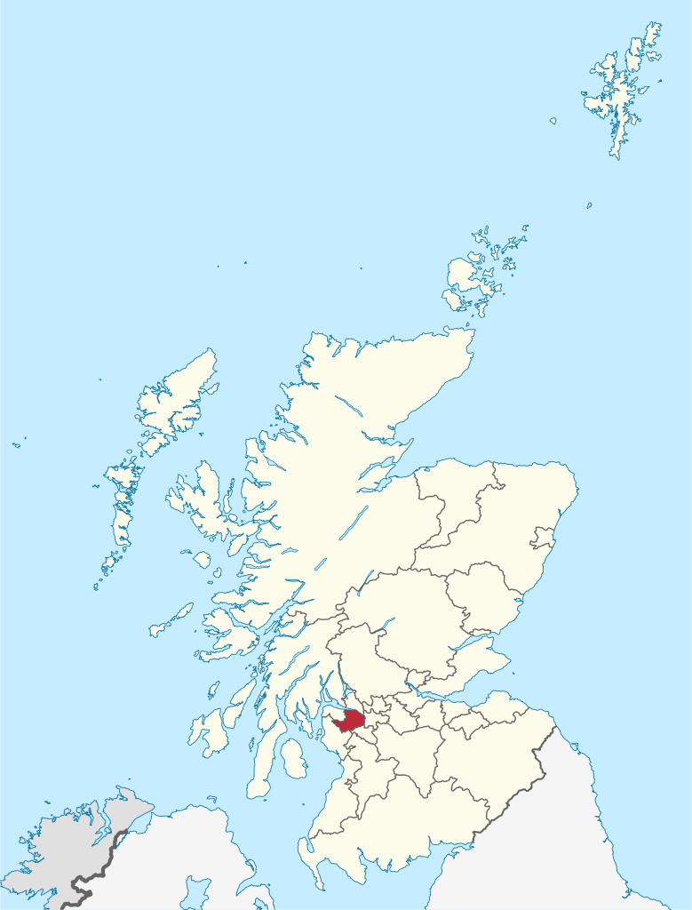
Renfrewshire (/ˈrɛnfruːʃɪər, -ʃər/) (Scots: Renfrewshire; Scottish Gaelic: Siorrachd Rinn Friù) is one of the 32 council areas of Scotland. The council area has the same name as the historic county of Renfrewshire, which had been abolished for local government purposes in 1975, but the modern council area only covers the central part of the historic county. The eastern part of the pre-1975 county is covered by the East Renfrewshire council area, and the western part by the Inverclyde council area. Renfrewshire is located in the west central Lowlands. It borders East Renfrewshire, Glasgow City council area, Inverclyde, North Ayrshire and West Dunbartonshire, and lies on the southern bank of the River Clyde. The current council area of Renfrewshire was established in 1996. (Source: Wikipedia.org, CC BY-SA)
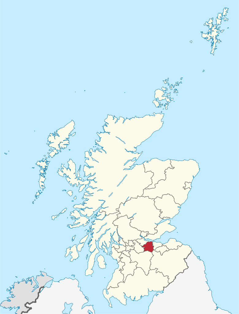
The Scottish Borders (Scots: the Mairches, lit. 'the Marches'; Scottish Gaelic: Crìochan na h-Alba) is one of 32 council areas of Scotland. It borders the City of Edinburgh council area, Dumfries and Galloway, East Lothian, Midlothian, South Lanarkshire, West Lothian and, to the south-west, south and east, the English unitary authorities of Cumberland and Northumberland. The administrative centre of the area is Newtown St Boswells. The term Scottish Borders, or normally just 'the Borders', is also used to designate the areas of southern Scotland and northern England that bound the Anglo-Scottish border. (Source: Wikipedia.org, CC BY-SA)
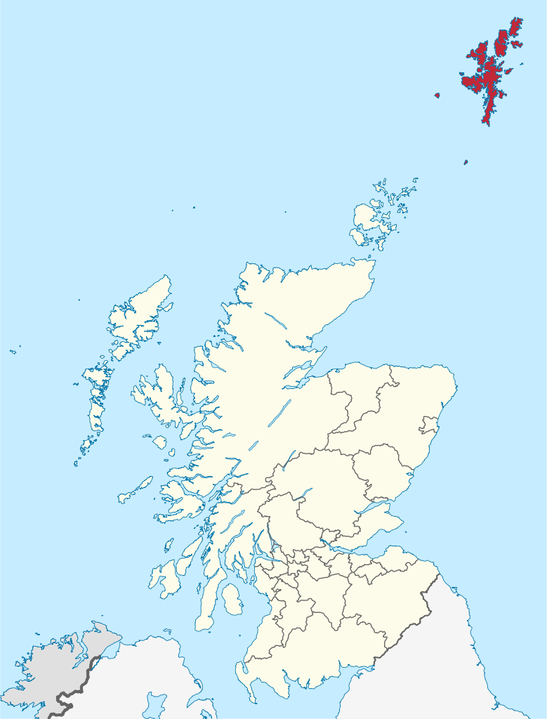
Shetland, also called the Shetland Islands and formerly Zetland, is an archipelago in Scotland lying between Orkney, the Faroe Islands, and Norway. It is the northernmost region of the United Kingdom. The islands lie about 80 km (50 mi) to the northeast of Orkney, 170 km (110 mi) from mainland Scotland and 220 km (140 mi) west of Norway. They form part of the border between the Atlantic Ocean to the west and the North Sea to the east. Their total area is 1,466 km2 (566 sq mi), and the population totalled 22,920 in 2019. The islands comprise the Shetland constituency of the Scottish Parliament. The local authority, the Shetland Islands Council, is one of the 32 council areas of Scotland. The islands' administrative centre, largest settlement and only burgh is Lerwick, which has been the capital of Shetland since 1708, before which time the capital was Scalloway. (Source: Wikipedia.org, CC BY-SA)
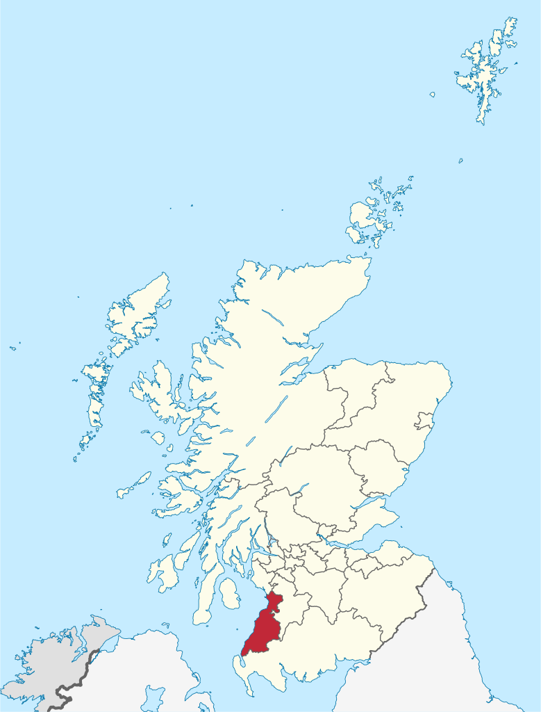
South Ayrshire (Scots: Sooth Ayrshire; Scottish Gaelic: Siorrachd Àir a Deas, pronounced [ˈʃirˠəxk ə tʲes̪]) is one of thirty-two council areas of Scotland, covering the southern part of Ayrshire. It borders onto Dumfries and Galloway, East Ayrshire and North Ayrshire. The area had an estimated population in 2021 of 112,450. Geographically, South Ayrshire is located on the western coast of Scotland, sharing borders with neighbouring local authorities East Ayrshire, Dumfries and Galloway and North Ayrshire. The climate in South Ayrshire, typical of that in western Scotland, is milder than that of eastern Scotland due to the stronger maritime influence, as the prevailing winds blow from the sea into South Ayrshire, which is located primarily on the western coast of Scotland. The warm Gulf Stream also has a strong influence on western Scotland. With winds mainly blowing from the sea the annual mean temperatures are in the range 9.5 to 9.9 °C (49.1 to 49.8 °F) in coastal areas of South Ayrshire such as Ayr and Troon. (Source: Wikipedia.org, CC BY-SA)
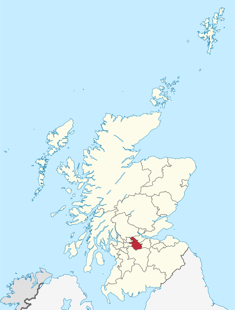
South Lanarkshire (Scots: Sooth Lanrikshire; Scottish Gaelic: Siorrachd Lannraig a Deas) is one of 32 unitary authorities of Scotland. It borders the south-east of the Glasgow City council area and contains some of Greater Glasgow's suburban towns, as well as many rural towns and villages. It also shares borders with Dumfries and Galloway, East Ayrshire, East Renfrewshire, North Lanarkshire, the Scottish Borders and West Lothian. It includes most of the historic county of Lanarkshire. The large and varied geographical territory takes in rural and upland areas, market towns such as Lanark, Strathaven and Carluke, the urban burghs of Rutherglen, Cambuslang, and East Kilbride which was Scotland's first new town. (Source: Wikipedia.org, CC BY-SA)
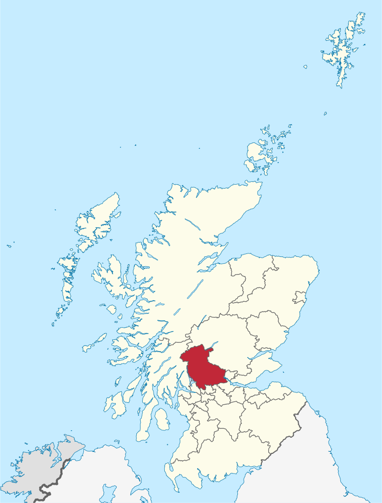
Stirling (/ˈstɜːrlɪŋ/; Scots: Stirlin; Scottish Gaelic: Sruighlea [ˈs̪t̪ɾuʝlə]) is a city in central Scotland, 26 miles (42 km) northeast of Glasgow and 37 miles (60 km) north-west of Edinburgh. The market town, surrounded by rich farmland, grew up connecting the royal citadel, the medieval old town with its merchants and tradesmen, the Old Bridge and the port. Located on the River Forth, Stirling is the administrative centre for the Stirling council area, and is traditionally the county town of Stirlingshire. Proverbially it is the strategically important 'Gateway to the Highlands'. It has been said that 'Stirling, like a huge brooch clasps Highlands and Lowlands together'. Similarly 'he who holds Stirling, holds Scotland' is sometimes attributed to Robert the Bruce. Stirling's key position as the lowest bridging point of the River Forth before it broadens towards the Firth of Forth made it a focal point for travel north or south. (Source: Wikipedia.org, CC BY-SA)
West Dunbartonshire (Scots: Wast Dunbairtonshire; Scottish Gaelic: Siorrachd Dhùn Breatann an Iar, pronounced [ˈʃirˠəxk ɣumˈpɾʲɛʰt̪ɪɲ ə ɲiəɾ]) is one of the 32 local government council areas of Scotland. The area lies to the north-west of the City of Glasgow and contains many of Glasgow's commuter towns and villages. West Dunbartonshire also borders Argyll and Bute, East Dunbartonshire, Renfrewshire and Stirling. The council area was formed in 1996 from the former Clydebank district and the eastern part of Dumbarton district, which had both been part of Strathclyde Region. (Source: Wikipedia.org, CC BY-SA)
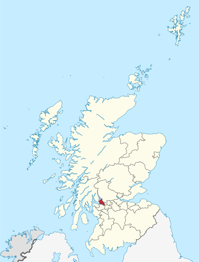
West Lothian (Scots: Wast Lowden; Scottish Gaelic: Lodainn an Iar) is one of the 32 council areas of Scotland, and was one of its historic counties. The county was called Linlithgowshire until 1925. The historic county was bounded geographically by the Avon to the west and the Almond to the east. The modern council area occupies a larger area than the historic county. It was reshaped following local government reforms in 1975: some areas in the west were transferred to Falkirk; some areas in the east were transferred to Edinburgh; and some areas that had formerly been part of Midlothian were added to West Lothian. (Source: Wikipedia.org, CC BY-SA)
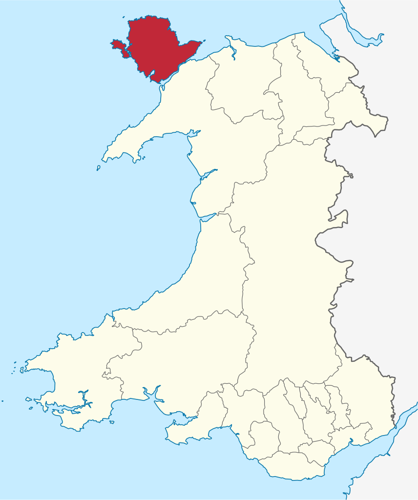
The Isle of Anglesey (/ˈæŋɡəlsiː/; Welsh: Ynys Môn [ˈənɨs ˈmoːn]) is a county off the north-west coast of Wales. It is named after the island of Anglesey, which makes up 94% of its area, but also includes Holy Island (Ynys Gybi) and some islets and skerries. The county borders Gwynedd across the Menai Strait to the southeast, and is otherwise surrounded by the Irish Sea. Holyhead is the largest town, and the administrative centre is Llangefni. The county is part of the preserved county of Gwynedd. (Source: Wikipedia.org, CC BY-SA)
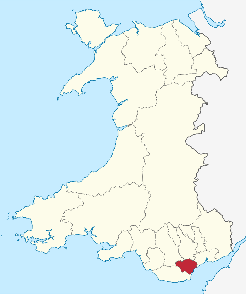
Blaenau Gwent (/ˌblaɪnaɪ ˈɡwɛnt/; Welsh: [ˈbləi.nai]) is a county borough in the south-east of Wales. It borders the unitary authority areas of Monmouthshire and Torfaen to the east, Caerphilly to the west and Powys to the north. Its main towns are Abertillery, Brynmawr, Ebbw Vale and Tredegar. Its highest point is Coity Mountain at 1,896 feet (578 m). (Source: Wikipedia.org, CC BY-SA)
Bridgend County Borough (Welsh: Bwrdeistref Sirol Pen-y-bont ar Ogwr) is a county borough in the south-east of Wales. The county borough has a total population of 139,200 people, and contains the town of Bridgend, after which it is named. Its members of the Senedd are Sarah Murphy MS, representing the Bridgend Constituency, and Huw Irranca-Davies MS representing the Ogmore Constituency, and its members of the UK parliament are Jamie Wallis and Chris Elmore. The county borough lies at the geographical heart of south Wales. Its land area of 110 mi2 (285 km2) stretches 12 miles (20 km) from east to west and occupies the Llynfi, Garw and Ogmore valleys. The largest town is Bridgend (pop: 39,773), followed by Maesteg (pop: 20,700) and Porthcawl (pop: 19,238). It is situated on the Ogmore River and its tributaries, although the Ewenny and Ogwr Fach rivers form the border with the Vale of Glamorgan for much of their length. (Source: Wikipedia.org, CC BY-SA)
Caerphilly County Borough (Welsh: Bwrdeistref Sirol Caerffili) is a county borough in the south-east of Wales. It is governed by Caerphilly County Borough Council. Its main and largest town is Caerphilly. Other towns in the county borough are Bedwas, Risca, Ystrad Mynach, Newbridge, Blackwood, Bargoed, New Tredegar and Rhymney. Caerphilly County Borough is in southeast Wales and straddles the border between the historic counties of Glamorgan and Monmouthshire. It is bordered by Cardiff to the southwest, Newport to the southeast, Torfaen to the east, Blaenau Gwent to the northeast, Powys to the north, Merthyr Tydfil to the northwest and Rhondda Cynon Taf to the west. (Source: Wikipedia.org, CC BY-SA)
Cardiff (/ˈkɑːrdɪf/; Welsh: Caerdydd [kairˈdiːð, kaːɨrˈdɨːð] ) is the capital and largest city of Wales. Cardiff had a population of 362,310 in 2021, forms a principal area officially known as the City and County of Cardiff (Welsh: Dinas a Sir Caerdydd), and the city is the eleventh-largest in the United Kingdom. Located in the south-east of Wales and in the Cardiff Capital Region, Cardiff is the county town of the historic county of Glamorgan and in 1974–1996 of South Glamorgan. It belongs to the Eurocities network of the largest European cities. A small town until the early 19th century, its prominence as a port for coal when mining began in the region helped its expansion. In 1905, it was ranked as a city and in 1955 proclaimed capital of Wales. Cardiff Built-up Area covers a larger area outside the county boundary, including the towns of Dinas Powys and Penarth. (Source: Wikipedia.org, CC BY-SA)
Carmarthenshire (/kərˈmɑːrðənʃər, -ʃɪər/; Welsh: Sir Gaerfyrddin [siːr gɑːɨrˈvərðɪn] or informally Sir Gâr) is a county in the south-west of Wales. The three largest towns are Llanelli, Carmarthen and Ammanford. Carmarthen is the county town and administrative centre. The county is known as the 'Garden of Wales' and is also home to the National Botanic Garden of Wales. Carmarthenshire has been inhabited since prehistoric times. The county town was founded by the Romans, and the region was part of the Kingdom of Deheubarth in the High Middle Ages. After invasion by the Normans in the 12th and 13th centuries it was subjugated, along with other parts of Wales, by Edward I of England. There was further unrest in the early 15th century, when the Welsh rebelled under Owain Glyndŵr, and during the English Civil War. (Source: Wikipedia.org, CC BY-SA)
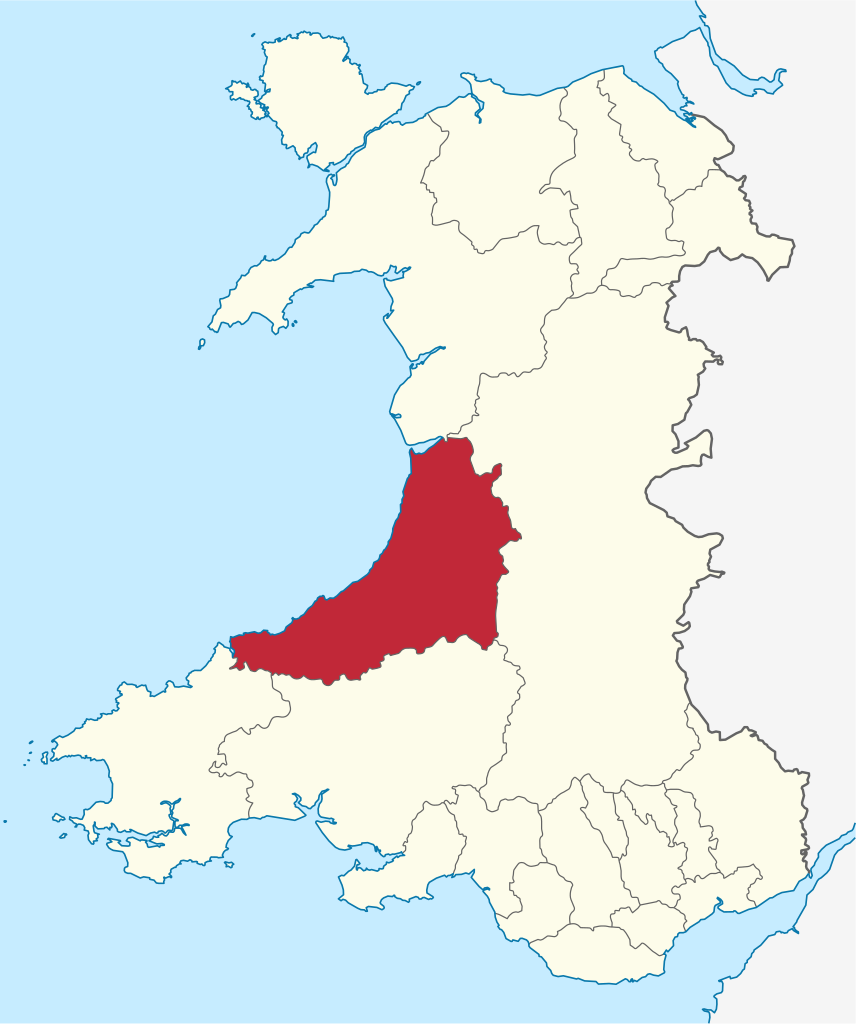
Ceredigion (UK: /ˌkɛrəˈdɪɡiən/ KERR-ə-DIG-ee-ən, US: /-iɒn/ -ee-on, Welsh: [kɛrɛˈdɪɡjɔn] ), historically Cardiganshire, is a county in the west of Wales. It borders Gwynedd across the Dyfi estuary to the north, Powys to the east, Carmarthenshire and Pembrokeshire to the south, and the Irish Sea to the west. Aberystwyth is the largest settlement, and together with Aberaeron is an administrative centre of Ceredigion County Council. The county is the second most sparsely populated in Wales, with an area of 688 square miles (1,780 km2) and a population of 71,500; the latter is a decline of 4,492 since the 2011 census. After Abersytwyth (15,935) the largest towns are Cardigan (4,184) and Lampeter (2,970). Ceredigion is considered a centre of Welsh culture, and 45.3% of the population could speak the Welsh language at the 2021 census. (Source: Wikipedia.org, CC BY-SA)
Conwy County Borough (Welsh: Bwrdeistref Sirol Conwy) is a county borough in the north of Wales. It borders Gwynedd to the west and south and Denbighshire to the east. The largest settlement is Colwyn Bay, and Conwy is the administrative centre. Conwy has an area of 435 square miles (1,130 km2) and a population of 114,800, making it sparsely populated. The population is concentrated along the coast, along which are several seaside resorts and the county's largest towns: Colwyn Bay (34,284), Llandudno (20,701), and Conwy (14,753). Inland is much less populous, and the only town is Llanrwst (3,323). The geography of Conwy is shaped by the River Conwy, which forms a wide valley down the western half of the county, bordered by the Denbigh Moors to the east and the mountains of Snowdonia National Park to the west. The River Elwy, a tributary of the Clwyd, drains the eastern half of the moors. The Conwy forms a wide estuary as it reaches the coast, which is characterised by wide, sandy beaches and the limestone headlands of the Great Orme and the Little Orme. (Source: Wikipedia.org, CC BY-SA)
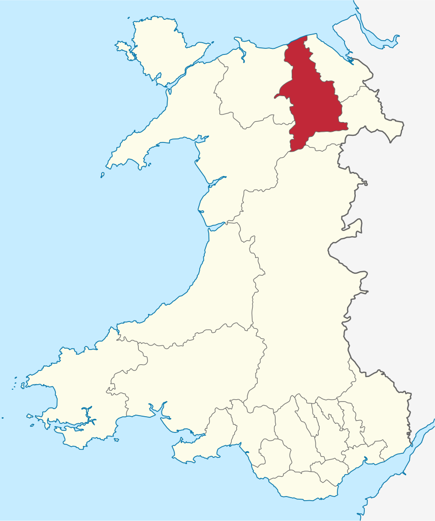
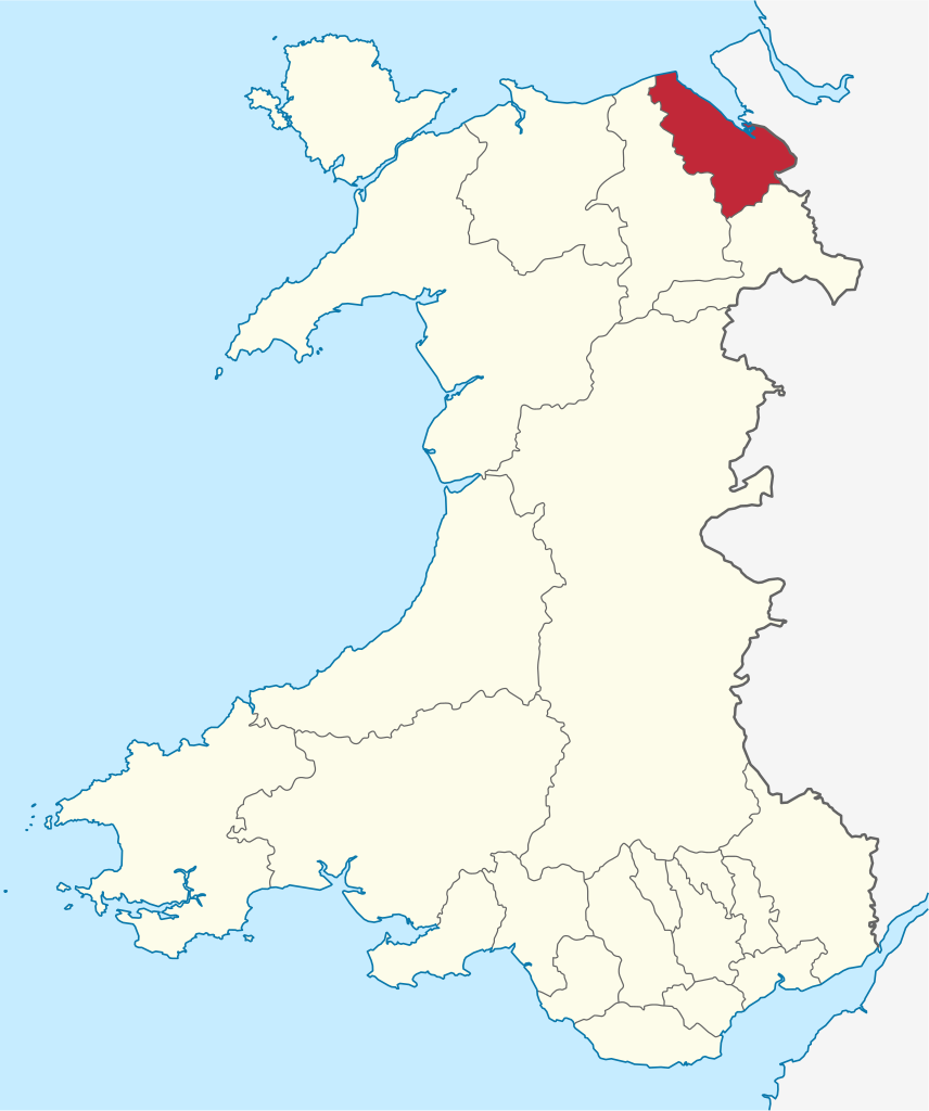
Denbighshire (/ˈdɛnbiʃər, -ʃɪər/ DEN-bee-shər, -sheer; Welsh: Sir Ddinbych [ˌsiːr ˈðɪnbɨχ]) is a county in the north-east of Wales. It borders the Irish Sea to the north, Flintshire to the east, Wrexham to the southeast, Powys to the south, and Gwynedd and Conwy to the west. Rhyl is the largest town, and Ruthin is the administrative centre. Its borders differ from the historic county of the same name. Denbighshire has an area of 326 square miles (840 km2) and a population of 95,800, making it sparsely populated. The most populous area is the coast, where Rhyl (25,149) and Prestatyn (19,085) form a single built-up area with a population of 46,267. The next-largest towns are Denbigh (8,986), Ruthin (5,461), and Rhuddlan (3,709). St Asaph (3,355) is a city. All of these settlements are in the northern half of the county; the south is even less densely populated, and the only towns are Corwen (2,325) and Llangollen (3,658). (Source: Wikipedia.org, CC BY-SA)
Flintshire (Welsh: Sir y Fflint) is a county in the north-east of Wales. It has a maritime border with Merseyside along the Dee Estuary to the north, and land borders with Cheshire to the east, Wrexham County Borough to the south, and Denbighshire to the west. Connah's Quay is the largest town, while Flintshire County Council is based in Mold. The county covers 169 square miles (440 km2), with a population of 155,000 in 2021. After Connah's Quay (16,771) the largest settlements are Flint (13,736), Buckley (16,127) and Mold (10,123). The east of the county is industrialised and contains the Deeside conurbation, which extends into Cheshire and has a population of 53,568. The adjacent coast is also home to industry, but further west has been developed for tourism, particularly at Talacre. Inland, the west of the county is sparsely populated and characterised by gentle hills, including part of the Clwydian Range and Dee Valley AONB. (Source: Wikipedia.org, CC BY-SA)
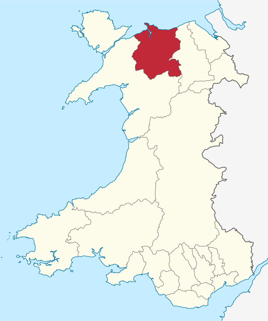
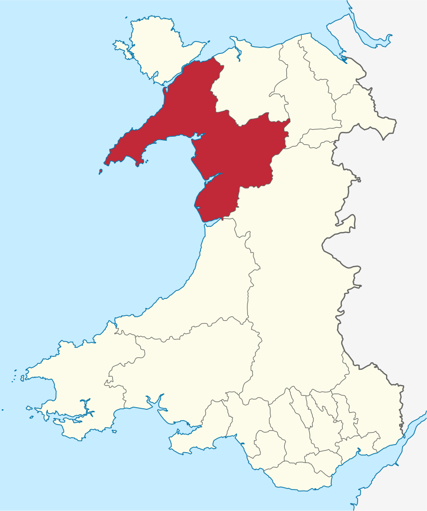
Gwynedd (English: /ˈɡwɪnɪð/; Welsh: [ˈɡwɨnɛð]) is a county in the north-west of Wales. It borders Anglesey across the Menai Strait to the north, Conwy, Denbighshire, and Powys to the east, Ceredigion over the Dyfi estuary to the south, and the Irish Sea to the west. The city of Bangor is the largest settlement, and the administrative centre is Caernarfon. The preserved county of Gwynedd, which is used for ceremonial purposes, includes the Isle of Anglesey. Gwynedd is the second largest county in Wales but sparsely populated, with an area of 979 square miles (2,540 km2) and a population of 117,400. After Bangor (18,322), the largest settlements are Caernarfon (9,852), Bethesda (4,735), and Pwllheli (4,076). The county has the highest percentage of Welsh speakers in Wales, at 64.4%, and is considered a heartland of the language. (Source: Wikipedia.org, CC BY-SA)
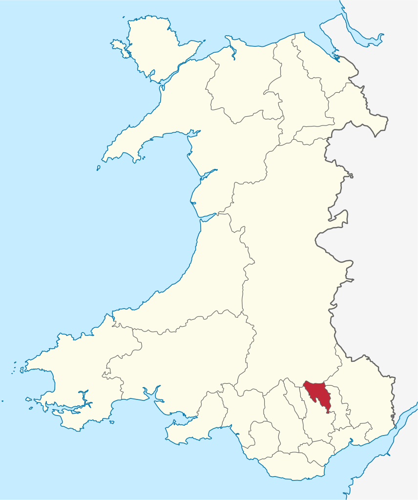
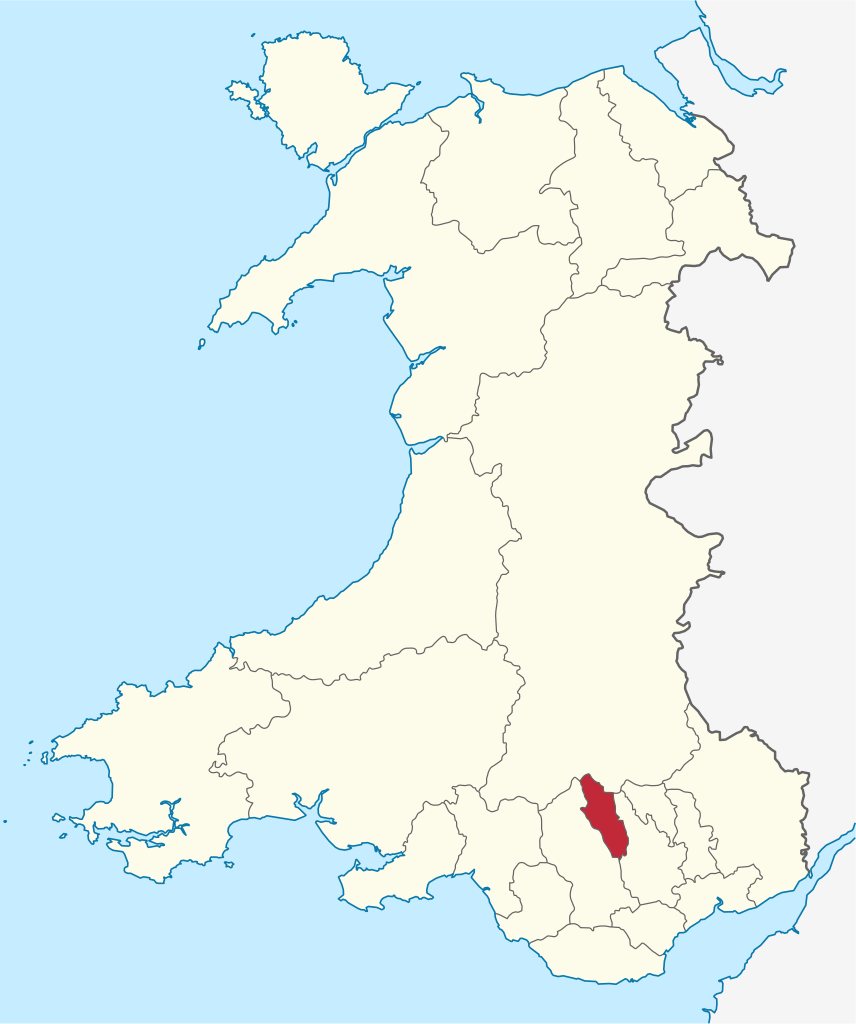
Merthyr Tydfil County Borough (Welsh: Bwrdeistref Sirol Merthyr Tudful) is a county borough (since 1908) in the south-east of Wales. In mid 2018, it had an estimated population of 60,183 making it the smallest local authority in Wales by both population and land area. It is located in the historic county of Glamorgan and takes its name from the town with the same name. The county borough consists of the northern part of the Taff Valley and the smaller neighbouring Taff Bargoed Valley. It borders the counties of Rhondda Cynon Taf to the west, Caerphilly County Borough to the east, and Powys to the north. (Source: Wikipedia.org, CC BY-SA)
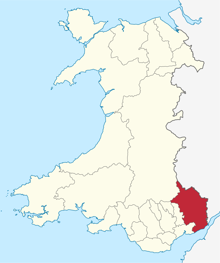
Monmouthshire (/ˈmɒnməθʃɪər, -ʃər, ˈmʌn-/ MON-məth-sheer, -shər, MUN-; Welsh: Sir Fynwy) is a county in the south east of Wales. It borders Powys to the north; the English counties of Herefordshire and Gloucestershire to the north and east; the Severn Estuary to the south, and Torfaen, Newport and Blaenau Gwent to the west. The largest town is Abergavenny, and the administrative centre is Usk. The county is rural, although adjacent to the city of Newport and the urbanised South Wales Valleys; it has an area of 330 square miles (850 km2) and a population of 93,000. After Abergavenny (12,515), the largest towns are Chepstow (12,350), Monmouth (10,508), and Caldicot (9,813). The county has one of the lowest percentages of Welsh speakers in Wales, at 8.2% of the population in 2021. (Source: Wikipedia.org, CC BY-SA)
Neath Port Talbot (Welsh: Castell-nedd Port Talbot) is a county borough in the south-west of Wales. Its principal towns are Neath, Port Talbot, Briton Ferry and Pontardawe. The county borough borders Bridgend County Borough and Rhondda Cynon Taf to the east, Powys and Carmarthenshire to the north; and Swansea to the west. Neath Port Talbot is the eighth-most populous local authority area in Wales and the third most populous county borough. The population at the 2011 census was 139,812. The population in the coastal areas is mainly English-speaking, whereas in the valleys in the north of the borough there are many who are Welsh-speaking. (Source: Wikipedia.org, CC BY-SA)
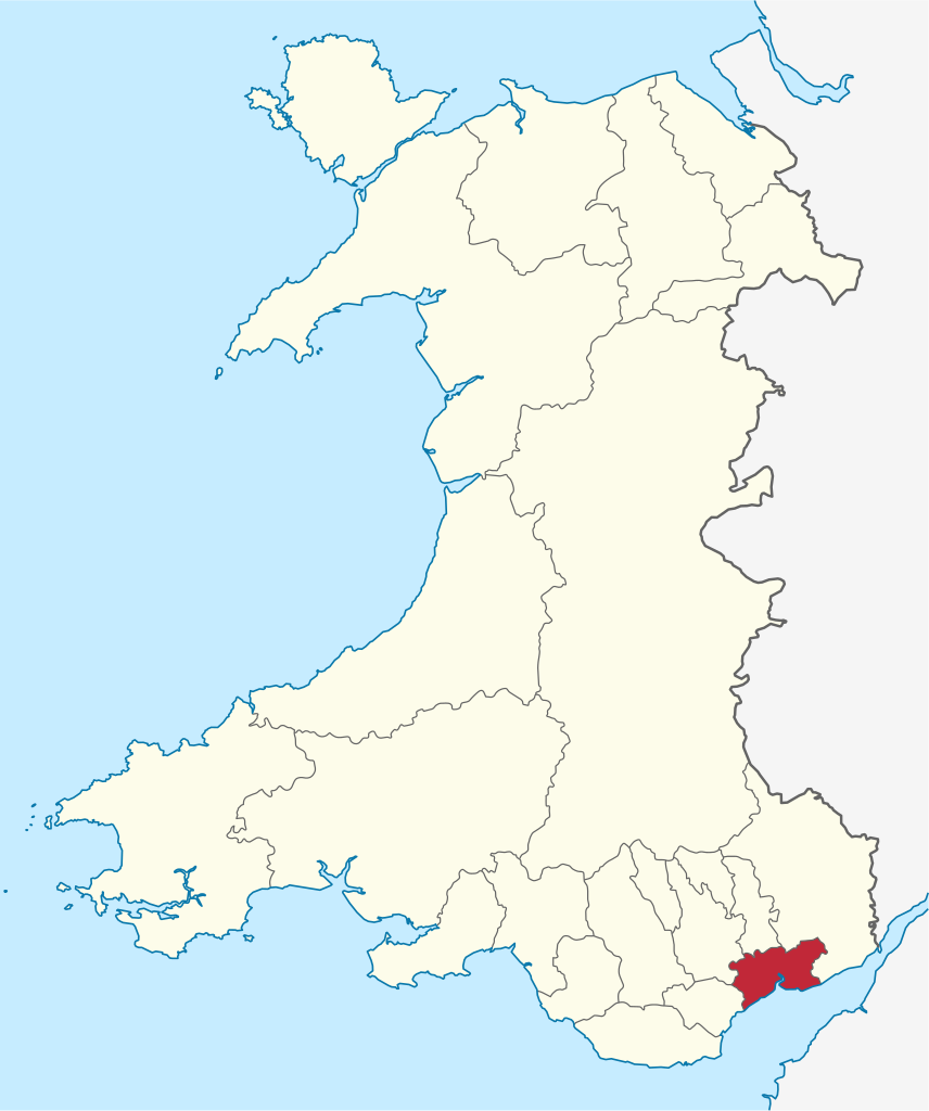
Newport (Welsh: Casnewydd; [kasˈnɛwɨð]) is a city and county borough in Wales, situated on the River Usk close to its confluence with the Severn Estuary, 12 mi (19 km) northeast of Cardiff. With a population of 145,700 at the 2011 census, Newport is the third-largest authority with city status in Wales, and seventh most populous overall. Newport became a unitary authority in 1996 and forms part of the Cardiff-Newport metropolitan area. Newport was the site of the last large-scale armed insurrection in Great Britain, the Newport Rising of 1839. The population grew considerably during the 2021 census, rising to 159,587, the largest growth of a unitary authority in Wales. (Source: Wikipedia.org, CC BY-SA)
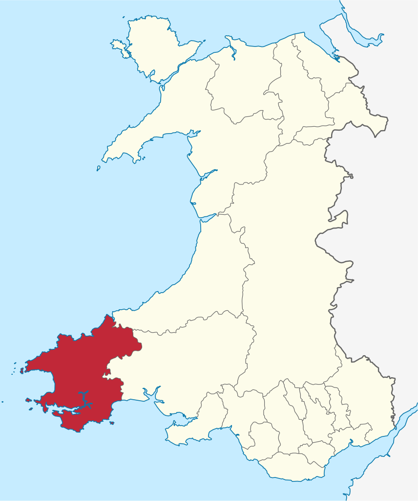
Pembrokeshire (/ˈpɛmbrʊkʃɪər, -ʃər/ PEM-bruuk-sheer, -shər; Welsh: Sir Benfro [siːr ˈbɛnvrɔ]) is a county in the south-west of Wales. It is bordered by Carmarthenshire to the east, Ceredigion to the northeast, and is otherwise surrounded by the sea. Haverfordwest is the largest town and administrative headquarters of Pembrokeshire County Council. The county is generally sparsely populated and rural, with an area of 200 square miles (520 km2) and a population of 123,400. After Haverfordwest, the largest settlements are Milford Haven (13,907), Pembroke Dock (9,753), and Pembroke (7,552). St Davids (1,841) is a city, the smallest by population in the UK. Welsh is spoken by 17.2 percent of the population, and for historic reasons is more widely spoken in the north of the county than in the south. (Source: Wikipedia.org, CC BY-SA)
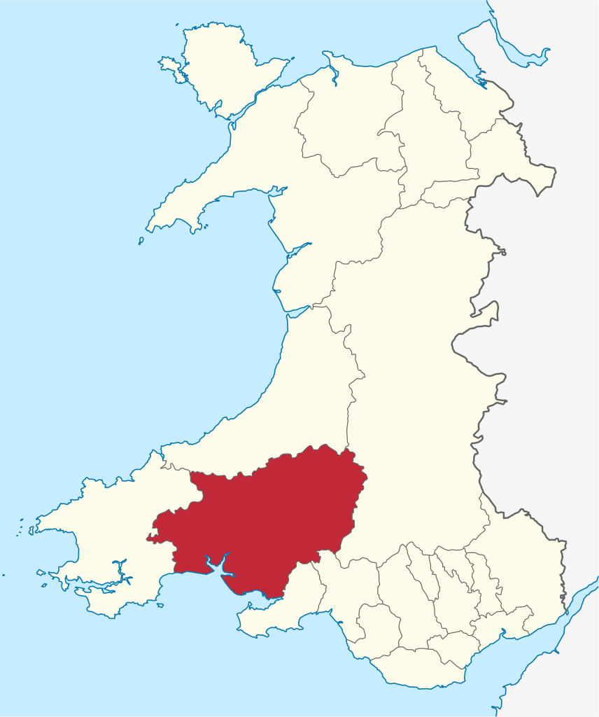
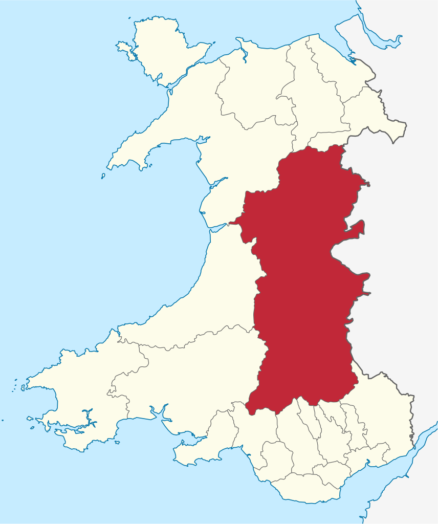
Powys (/ˈpoʊɪs, ˈpaʊɪs/ POH-iss, POW-iss, Welsh: [ˈpowɪs]) is a county and preserved county in Wales. It borders Gwynedd, Denbighshire, and Wrexham to the north; the English ceremonial counties of Shropshire and Herefordshire to the east; Monmouthshire, Blaenau Gwent, Merthyr Tydfil, Caerphilly, Rhondda Cynon Taf, and Neath Port Talbot to the south; and Carmarthenshire and Ceredigion to the west. The largest settlement is Newtown, and the administrative centre is Llandrindod Wells. Powys is the largest and most sparsely populated county in Wales, having an area of 2,000 square miles (5,200 km2) and a population of 133,200. After Newtown (11,362), the most populous settlements are Brecon (8,250), Ystradgynlais (8,092), and Welshpool (5,948). The county is entirely rural, and characterised by multiple market towns and villages. The Welsh language can be spoken by 16.4% of the population. (Source: Wikipedia.org, CC BY-SA)
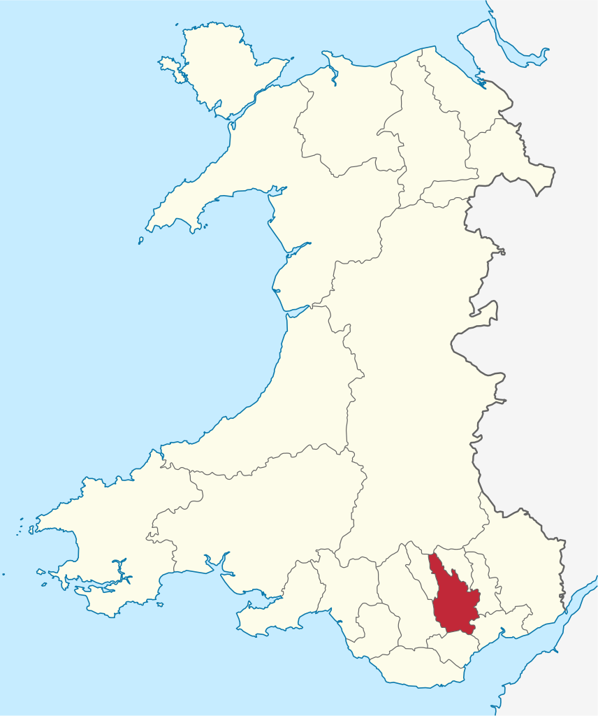
Rhondda Cynon Taf (Welsh pronunciation: [ˈr̥ɔnða ˈkənɔn ˈtaːv]; RCT; also spelt as Rhondda Cynon Taff) is a county borough in the south-east of Wales. It consists of five valleys: the Rhondda Fawr, Rhondda Fach, Cynon, Taff (Welsh: Taf) and Ely valleys, plus a number of towns and villages away from the valleys. Results from the 2011 census showed 19.1% of its 234,410 residents self-identified as having some ability in the use of the Welsh language. The county borough borders Merthyr Tydfil County Borough and Caerphilly County Borough to the east, Cardiff and the Vale of Glamorgan to the south, Bridgend County Borough and Neath Port Talbot to the west and Powys to the north. Its principal towns are - Aberdare, Llantrisant with Talbot Green and Pontypridd, with other key settlements/towns being - Maerdy, Ferndale, Hirwaun, Llanharan, Mountain Ash, Porth, Tonypandy, Tonyrefail and Treorchy. (Source: Wikipedia.org, CC BY-SA)
Swansea (/ˈswɒnzi/; Welsh: Abertawe [abɛrˈtawɛ]) is a coastal city and the second-largest city of Wales. It forms a principal area, officially known as the City and County of Swansea (Welsh: Dinas a Sir Abertawe). The city is the twenty-fifth largest in the United Kingdom. Located along Swansea Bay in southwest Wales, with the principal area covering the Gower Peninsula, it is part of the Swansea Bay region and part of the historic county of Glamorgan; also the ancient Welsh commote of Gŵyr. The principal area is the second most populous local authority area in Wales with an estimated population of 246,563 in 2020. Swansea, along with Neath and Port Talbot, forms the Swansea Urban Area with a population of 300,352 in 2011. It is also part of the Swansea Bay City Region. During the 19th-century industrial heyday, Swansea was the key centre of the copper-smelting industry, earning the nickname Copperopolis. (Source: Wikipedia.org, CC BY-SA)
Torfaen (/tɔːrˈvaɪn/; [tɔrˈvaɪn]) is a county borough in the south-east of Wales. Torfaen is bordered by the county of Monmouthshire to the east, the city of Newport to the south, and the county boroughs of Caerphilly and Blaenau Gwent to the south-west and north-west. It is within the boundaries of the historic county of Monmouthshire, and between 1974 and 1996 was a district of Gwent, until it was reconstituted as a principal area in 1996. The area has a population of around 91,000. Much of the southern part of the county borough around Cwmbran is extensively urban. The north of the county borough is greener and retains extensive areas of countryside, especially on the route to Blaenavon. (Source: Wikipedia.org, CC BY-SA)
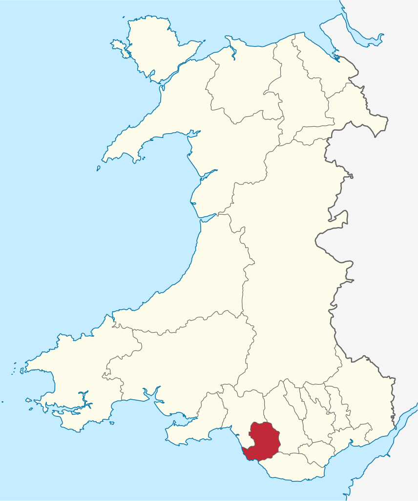
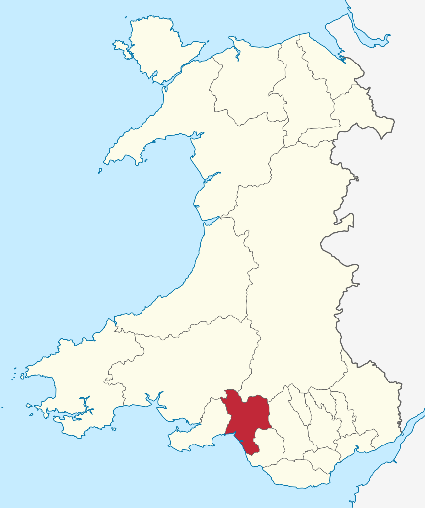
The Vale of Glamorgan (Welsh: Bro Morgannwg [ˈbroː mɔrˈɡanʊɡ]), often referred to as The Vale, is a county borough in the south-east of Wales. It borders Bridgend County Borough to the west, Cardiff to the east, Rhondda Cynon Taf to the north, and the Bristol Channel to the south. With an economy based largely on agriculture and chemicals, it is the southernmost unitary authority in Wales. Attractions include Barry Island Pleasure Park, the Barry Tourist Railway, Medieval wall paintings in St Cadoc's Church, Llancarfan, Porthkerry Park, St Donat's Castle, Cosmeston Lakes Country Park and Cosmeston Medieval Village. The largest town is Barry. Other towns include Penarth, Llantwit Major, and Cowbridge. There are many villages in the county borough. (Source: Wikipedia.org, CC BY-SA)
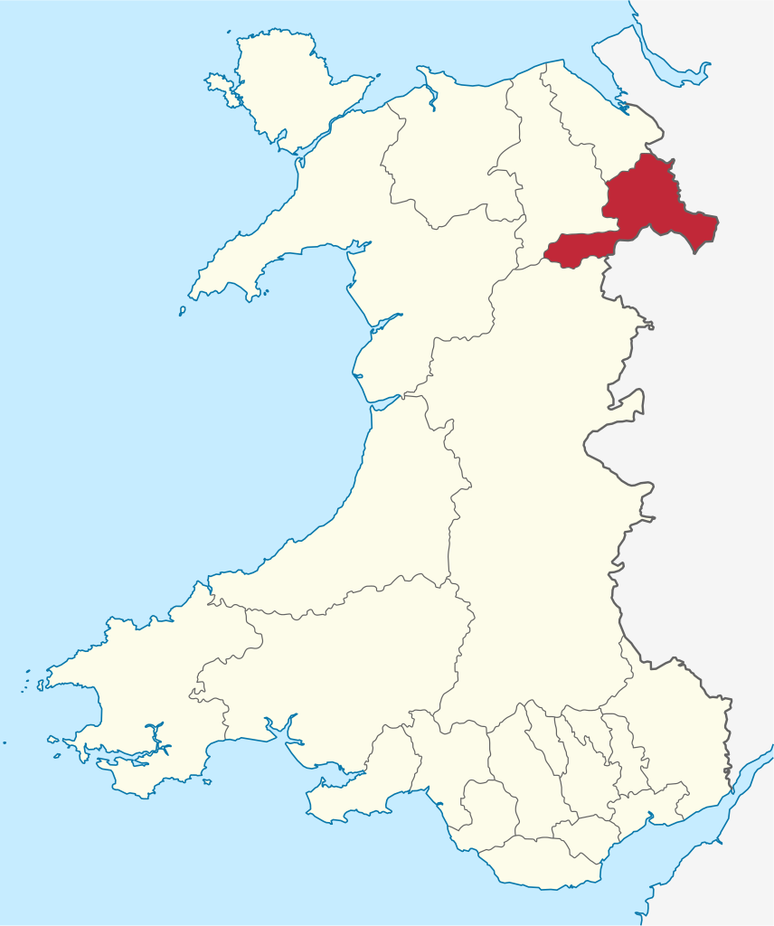
Wrexham County Borough (Welsh: Bwrdeistref Sirol Wrecsam) is a county borough, with city status, in the north-east of Wales. It borders the English ceremonial counties of Cheshire and Shropshire to the east and south-east respectively, Powys to the south-west, Denbighshire to the west and Flintshire to the north-west. The city of Wrexham is the administrative centre. The county borough has an area of 193 square miles (500 km2) and a population of 136,055. The north of the county is relatively urbanised, containing Wrexham (61,603), its large industrial estate, and commuter villages. South of Wrexham, Rhosllanerchrugog (9,694) Ruabon (4,274), and Cefn Mawr (7,051) are the main villages in an urban area with a population of 25,362. Further south again is Chirk (4,468). The southeast and southwest of the county are rural. (Source: Wikipedia.org, CC BY-SA)

Help us promote traffic rules on the internet, together we can make the public road safer for everyone. Post a comment or share on social media!
Most problems are a result of higher than safe driving speeds. Please just slow down and be patient.
 0
0
Question 121: Poor translation: Vehicles with polluted fluids prohibited Should be translated as: Vehicles with dangerous liquids prohibited
0
Question 83: Poor translation: Vehicles with polluted fluids prohibited Should be translated as: Vehicles with dangerous liquids prohibited
0
Want even more practice? Visit similar websites offering realistic practice driving knowledge tests. Visit us to see what sets our tests apart! https://dkttest.com/capital-territory/
0
Cool tool! And fun to check whether I remember the rules :) Two things I noticed: Warning for a crossroad side roads on the left and right. While technically that might be the correct translation, this sign tells you, that you are on the main road and have the right of way for the next crossroad and only the next crossroad. Usually (if no sign specifies otherwise) you have to give way to drivers coming from the right at every intersection, which can get a bit annoying in communal areas, so seeing this sign feels less like a warning and more like relief :). A Fahrradstraße is not a lane for cyclists but a street for cyclists, meaning the (whole!) street is intended predominantly for cyclists, who are then allowed to ride next to each other. Cars are allowed to drive there (unless another sign prohibits such), but have to adjust their speed to the cyclists. I believe they are not allowed to pass at all, even if the oncoming lane is empty.
0
this website is a simpy website i love this its fat and im in my mums basement rn help sui u r a mothr fker
3
Hi i am such fat fan of this great gaming website. Im so hangry for the cause mate! Liking the simps eating on yall tho nott gonna lie to ya!
0
The system is now changed and they use some type of tablet for the exam now. Do anyone have the questions which they ask in the tablet because the questions are different. I still didn’t pass my provisional driving knowledge test. It would be great if someone could help
0
Good exercise !! Looking for some drift friends, hit to my email Funnyparts@gmail.com
The exercise of the activity of TVDE driver, without it being registered on an electronic platform, incurs:
0
Who will be responsible for infractions that may be committed and for damages caused to third parties, without prejudice to the corresponding administrative sanctions:
0
This answer is incorrect. What does this traffic sign mean? Square sign with a circular not parking inside. Choices: Begin of a zone where parking is allowed, Being of a zone with a speed limit, Begin of zone where parking is prohibited, Begin of a residential area. The correct answer should be Begin of a zone where parking is allowed NOT Begin of zone where parking is prohibited. It is a Controlled parking Zone.
0


More community