


Additional signsIndonesia
 Traffic rules
 Indonesia
 Priority signs
 Warning signs
 Prohibitory signs
 Mandatory signs
 Information signs
 Additional signs
An additional sign is a traffic sign placed directly below another sign to provide extra information or clarify how the main sign should be understood. It can specify conditions such as distance, time periods, road users affected, directions, or special circumstances. Additional signs do not create new rules by themselves but modify, limit, or explain the meaning of the sign above them so drivers can apply the rule correctly in that specific situation.









Why must I read a supplementary plate?
It can qualify the main sign by identifying an exception, a time period or the distance to a restriction. Read the complete assembly rather than applying only the main symbol.

1. For buses
This supplementary sign indicates that the main traffic sign applies specifically to buses. The vehicle categories covered depend on the applicable local definitions.
English • Supplementary plate PM 13/2014 • VII.4 • Buses only. Limits the main sign's application specifically to buses.
Bahasa Indonesia • PM 13/2014 • VII.4 • Khusus bus. Papan tambahan membatasi penerapan rambu utama khusus untuk mobil bus.
Sources
🔗 Commons.wikimedia.org (มองโกเลีย๔๔ • CC BY-SA 4.0)
🔗 Andalalin.jakarta.go.id • PM 13 Tahun 2014 • Lampiran • hlm. PDF 182
SVG source: มองโกเลีย๔๔ • CC BY-SA 4.0 • Original revision 2020-05-26. Wikimedia original unmodified.
2. Buses allowed
This supplementary sign indicates that buses are allowed where the main traffic sign would otherwise restrict their access or use. The bus categories covered depend on the applicable local definitions.
English • Supplementary plate PM 13/2014 • VII.4 • Except buses. Exempts buses from the main sign's requirements.
Bahasa Indonesia • PM 13/2014 • VII.4 • Kecuali bus. Papan tambahan mengecualikan mobil bus dari ketentuan rambu utama.
Sources
🔗 Commons.wikimedia.org (มองโกเลีย๔๔ • CC BY-SA 4.0)
🔗 Andalalin.jakarta.go.id • PM 13 Tahun 2014 • Lampiran • hlm. PDF 182
SVG source: มองโกเลีย๔๔ • CC BY-SA 4.0 • Original revision 2020-05-26. Wikimedia original unmodified.
3. To the left
This supplementary sign indicates that the main traffic sign applies in the direction shown by the arrow, to the left.
English • Supplementary plate PM 13/2014 • VII.2 • Leftward application. Specifies the main sign's application to the left.
Bahasa Indonesia • PM 13/2014 • VII.2 • Arah kiri. Papan tambahan menjelaskan penerapan rambu utama ke arah kiri.
Sources
🔗 Commons.wikimedia.org (มองโกเลีย๔๔ • CC BY-SA 4.0)
🔗 Andalalin.jakarta.go.id • PM 13 Tahun 2014 • Lampiran • hlm. PDF 180
SVG source: มองโกเลีย๔๔ • CC BY-SA 4.0 • Original revision 2020-05-26. Wikimedia original unmodified.
4. To the left or right
This supplementary sign indicates that the main traffic sign applies in both directions shown by the arrows, to the left and right.
English • Supplementary plate PM 13/2014 • VII.2 • Leftward and rightward application. Specifies the main sign's application to the left and right.
Bahasa Indonesia • PM 13/2014 • VII.2 • Arah kiri dan kanan. Papan tambahan menjelaskan penerapan rambu utama ke arah kiri dan kanan.
Sources
🔗 Commons.wikimedia.org (มองโกเลีย๔๔ • CC BY-SA 4.0)
🔗 Andalalin.jakarta.go.id • PM 13 Tahun 2014 • Lampiran • hlm. PDF 180
SVG source: มองโกเลีย๔๔ • CC BY-SA 4.0 • Original revision 2020-05-26. Wikimedia original unmodified.
5. To the right
This supplementary sign indicates that the main traffic sign applies in the direction shown by the arrow, to the right.
English • Supplementary plate PM 13/2014 • VII.2 • Rightward application. Specifies the main sign's application to the right.
Bahasa Indonesia • PM 13/2014 • VII.2 • Arah kanan. Papan tambahan menjelaskan penerapan rambu utama ke arah kanan.
Sources
🔗 Commons.wikimedia.org (มองโกเลีย๔๔ • CC BY-SA 4.0)
🔗 Andalalin.jakarta.go.id • PM 13 Tahun 2014 • Lampiran • hlm. PDF 180
SVG source: มองโกเลีย๔๔ • CC BY-SA 4.0 • Original revision 2020-05-26. Wikimedia original unmodified.
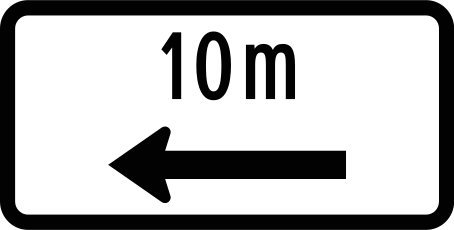
6. metres to the left
This supplementary sign indicates that the main traffic sign refers to a location the indicated distance to the left.
English • Supplementary plate PM 13/2014 • VII.3 • 10 m to the left. The main sign applies for 10 m to the left.
Bahasa Indonesia • PM 13/2014 • VII.3 • 10 m ke kiri. Papan tambahan menjelaskan cakupan rambu utama sejauh 10 m ke kiri.
Sources
🔗 Commons.wikimedia.org (มองโกเลีย๔๔ • CC BY-SA 4.0)
🔗 Andalalin.jakarta.go.id • PM 13 Tahun 2014 • Lampiran • hlm. PDF 181
SVG source: มองโกเลีย๔๔ • CC BY-SA 4.0 • Original revision 2020-05-26. Wikimedia original unmodified.
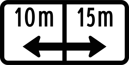
7. metres to the left or right
This supplementary sign indicates that the main traffic sign refers to locations the indicated distance to the left and right.
English • Supplementary plate PM 13/2014 • VII.3 • 10 m left and 15 m right. The main sign applies over those distances as shown.
Bahasa Indonesia • PM 13/2014 • VII.3 • 10 m ke kiri dan 15 m ke kanan. Papan tambahan menjelaskan cakupan rambu utama sejauh 10 m ke kiri dan 15 m ke kanan, sesuai angka pada gambar.
Sources
🔗 Commons.wikimedia.org (มองโกเลีย๔๔ • CC BY-SA 4.0)
🔗 Andalalin.jakarta.go.id • PM 13 Tahun 2014 • Lampiran • hlm. PDF 181
SVG source: มองโกเลีย๔๔ • CC BY-SA 4.0 • Original revision 2020-05-26. Wikimedia original unmodified.
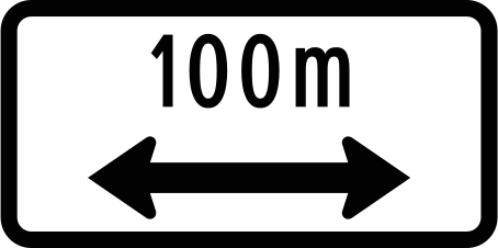
8. metres to the left or right
This supplementary sign indicates that the main traffic sign refers to locations the indicated distance to the left and right.
English • Supplementary plate PM 13/2014 • VII.3 • 100 m left and right. Specifies 100 m application in the arrow directions; read with the main sign.
Bahasa Indonesia • PM 13/2014 • VII.3 • 100 m ke kiri dan kanan. Papan tambahan menjelaskan cakupan 100 m ke arah kiri dan kanan sesuai panah, dibaca bersama rambu utama.
Sources
🔗 Commons.wikimedia.org (มองโกเลีย๔๔ • CC BY-SA 4.0)
🔗 Andalalin.jakarta.go.id • PM 13 Tahun 2014 • Lampiran • hlm. PDF 181
SVG source: มองโกเลีย๔๔ • CC BY-SA 4.0 • Original revision 2020-05-26. Wikimedia original unmodified.
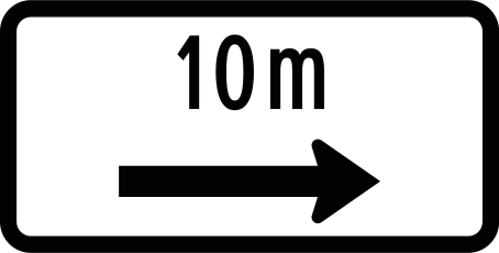
9. metres to the right
This supplementary sign indicates that the main traffic sign refers to a location the indicated distance to the right.
English • Supplementary plate PM 13/2014 • VII.3 • 10 m to the right. The main sign applies for 10 m to the right.
Bahasa Indonesia • PM 13/2014 • VII.3 • 10 m ke kanan. Papan tambahan menjelaskan cakupan rambu utama sejauh 10 m ke kanan.
Sources
🔗 Commons.wikimedia.org (มองโกเลีย๔๔ • CC BY-SA 4.0)
🔗 Andalalin.jakarta.go.id • PM 13 Tahun 2014 • Lampiran • hlm. PDF 182
SVG source: มองโกเลีย๔๔ • CC BY-SA 4.0 • Original revision 2020-05-26. Wikimedia original unmodified.
10. Start of regulation
This supplementary sign indicates the start of the regulation shown by the main traffic sign. The regulation begins at this point.
English • Supplementary plate PM 13/2014 • VII.2 • Forward application. Specifies the main sign's application ahead; read them together.
Bahasa Indonesia • PM 13/2014 • VII.2 • Arah ke depan. Papan tambahan menjelaskan penerapan rambu utama ke arah depan. Maknanya harus dibaca bersama rambu utama.
Sources
🔗 Commons.wikimedia.org (มองโกเลีย๔๔ • CC BY-SA 4.0)
🔗 Andalalin.jakarta.go.id • PM 13 Tahun 2014 • Lampiran • hlm. PDF 181
SVG source: มองโกเลีย๔๔ • CC BY-SA 4.0 • Original revision 2020-05-26. Wikimedia original unmodified.
11. Continuation of regulation
This supplementary sign indicates the continuation or reminder of the regulation shown by the main traffic sign.
English • Supplementary plate PM 13/2014 • VII.2 • Forward and backward application. Specifies the main sign's application in both directions along the road.
Bahasa Indonesia • PM 13/2014 • VII.2 • Arah ke depan dan belakang. Papan tambahan menjelaskan penerapan rambu utama ke arah depan dan belakang.
Sources
🔗 Commons.wikimedia.org (มองโกเลีย๔๔ • CC BY-SA 4.0)
🔗 Andalalin.jakarta.go.id • PM 13 Tahun 2014 • Lampiran • hlm. PDF 181
SVG source: มองโกเลีย๔๔ • CC BY-SA 4.0 • Original revision 2020-05-26. Wikimedia original unmodified.
12. End of regulation
This supplementary sign indicates the end of the regulation shown by the main traffic sign. The regulation ends at this point.
English • Supplementary plate PM 13/2014 • VII.2 • Backward application. Specifies the main sign's application behind the sign; read them together.
Bahasa Indonesia • PM 13/2014 • VII.2 • Arah ke belakang. Papan tambahan menjelaskan penerapan rambu utama ke arah belakang. Maknanya harus dibaca bersama rambu utama.
Sources
🔗 Commons.wikimedia.org (มองโกเลีย๔๔ • CC BY-SA 4.0)
🔗 Andalalin.jakarta.go.id • PM 13 Tahun 2014 • Lampiran • hlm. PDF 181
SVG source: มองโกเลีย๔๔ • CC BY-SA 4.0 • Original revision 2020-05-26. Wikimedia original unmodified.
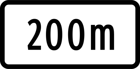
13. metres ahead
This supplementary sign indicates the distance from the main traffic sign to the point where the indicated danger, regulation or information begins. The distance is shown in metres.
English • Supplementary plate PM 13/2014 • VII.1 • Distance: 200 m. Shows the distance to the location or requirement indicated by the main sign.
Bahasa Indonesia • PM 13/2014 • VII.1 • Jarak 200 m. Papan tambahan menyatakan jarak 200 m untuk lokasi atau ketentuan yang ditunjukkan oleh rambu utama.
Sources
🔗 Commons.wikimedia.org (มองโกเลีย๔๔ • CC BY-SA 4.0)
🔗 Andalalin.jakarta.go.id • PM 13 Tahun 2014 • Lampiran • hlm. PDF 180
SVG source: มองโกเลีย๔๔ • CC BY-SA 4.0 • Original revision 2020-05-25. Wikimedia original unmodified.
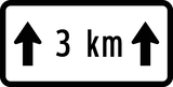
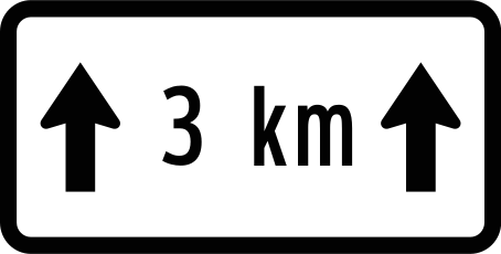
14. For kilometres
This supplementary sign indicates the length of the section to which the main traffic sign applies. The length is shown in kilometres.
English • Supplementary plate PM 13/2014 • VII.3 • Application for 3 km ahead. The main sign applies over the next 3 km.
Bahasa Indonesia • PM 13/2014 • VII.3 • Cakupan 3 km ke depan. Papan tambahan menjelaskan penerapan rambu utama sepanjang 3 km ke depan.
Sources
🔗 Commons.wikimedia.org (มองโกเลีย๔๔ • CC BY-SA 4.0)
🔗 Andalalin.jakarta.go.id • PM 13 Tahun 2014 • Lampiran • hlm. PDF 182
SVG source: มองโกเลีย๔๔ • CC BY-SA 4.0 • Original revision 2020-05-26. Wikimedia original unmodified.
15. Parallel parking
This supplementary sign indicates that vehicles must park parallel to the kerb, as shown.
English • Supplementary plate PM 13/2014 • VII.4 • Parallel parking. Specifies parallel parking when used with a parking sign.
Bahasa Indonesia • PM 13/2014 • VII.4 • Parkir paralel. Papan tambahan menjelaskan konfigurasi parkir paralel apabila digunakan bersama rambu parkir.
Sources
🔗 Commons.wikimedia.org (มองโกเลีย๔๔ • CC BY-SA 4.0)
🔗 Andalalin.jakarta.go.id • PM 13 Tahun 2014 • Lampiran • hlm. PDF 183
SVG source: มองโกเลีย๔๔ • CC BY-SA 4.0 • Original revision 2020-05-26. Wikimedia original unmodified.
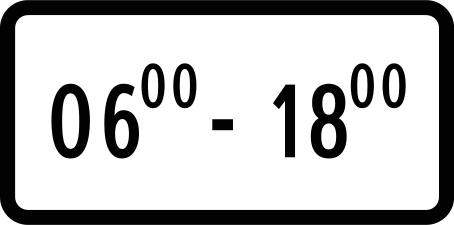
16. During the time shown
This supplementary sign indicates that the main traffic sign applies during the time shown.
English • Supplementary plate PM 13/2014 • VII.1 • Operating times: 06.00–18.00. The main sign applies from 06.00 to 18.00.
Bahasa Indonesia • PM 13/2014 • VII.1 • Waktu 06.00–18.00. Papan tambahan menjelaskan bahwa ketentuan rambu utama berlaku pukul 06.00 hingga 18.00.
Sources
🔗 Commons.wikimedia.org (มองโกเลีย๔๔ • CC BY-SA 4.0)
🔗 Andalalin.jakarta.go.id • PM 13 Tahun 2014 • Lampiran • hlm. PDF 180
SVG source: มองโกเลีย๔๔ • CC BY-SA 4.0 • Original revision 2020-05-25. Wikimedia original unmodified.
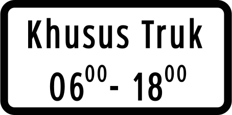
17. Deliveries allowed during the time shown
This supplementary sign indicates that deliveries are allowed during the time shown.
English • Supplementary plate PM 13/2014 • VII.5 • Lorries only, 06.00–18.00. The main sign applies specifically to lorries from 06.00 to 18.00.
Bahasa Indonesia • PM 13/2014 • VII.5 • Khusus truk 06.00–18.00. Papan tambahan menjelaskan bahwa ketentuan rambu utama berlaku khusus untuk truk pukul 06.00 hingga 18.00.
Sources
🔗 Commons.wikimedia.org (มองโกเลีย๔๔ • CC BY-SA 4.0)
🔗 Andalalin.jakarta.go.id • PM 13 Tahun 2014 • Lampiran • hlm. PDF 183
SVG source: มองโกเลีย๔๔ • CC BY-SA 4.0 • Original revision 2020-05-26. Wikimedia original unmodified.
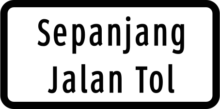
18. Toll road
This supplementary sign indicates that the road concerned is subject to a toll.
English • Supplementary plate PM 13/2014 • VII.4 • Throughout the toll road. The main sign's requirements apply along the toll road.
Bahasa Indonesia • PM 13/2014 • VII.4 • Sepanjang jalan tol. Papan tambahan menjelaskan bahwa ketentuan rambu utama berlaku sepanjang jalan tol.
Sources
🔗 Commons.wikimedia.org (มองโกเลีย๔๔ • CC BY-SA 4.0)
🔗 Andalalin.jakarta.go.id • PM 13 Tahun 2014 • Lampiran • hlm. PDF 183
SVG source: มองโกเลีย๔๔ • CC BY-SA 4.0 • Original revision 2020-05-26. Wikimedia original unmodified.
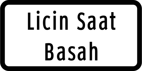
19. Aquaplaning
This supplementary sign warns of a risk of aquaplaning, where tyres lose contact with the road surface because of water.
English • Supplementary plate PM 13/2014 • VII.4 • Slippery when wet. Explains the danger of a slippery road surface when wet.
Bahasa Indonesia • PM 13/2014 • VII.4 • Licin saat basah. Papan tambahan menjelaskan bahaya permukaan jalan yang licin ketika basah.
Sources
🔗 Commons.wikimedia.org (มองโกเลีย๔๔ • CC BY-SA 4.0)
🔗 Andalalin.jakarta.go.id • PM 13 Tahun 2014 • Lampiran • hlm. PDF 182
SVG source: มองโกเลีย๔๔ • CC BY-SA 4.0 • Original revision 2020-05-26. Wikimedia original unmodified.
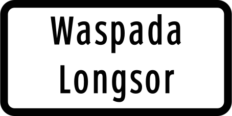
20. Landslide
This supplementary sign warns of a risk of landslides or earth and debris on the road.
English • Supplementary plate PM 13/2014 • VII.4 • Landslide warning. Specifies the landslide danger on the section indicated by the main sign.
Bahasa Indonesia • PM 13/2014 • VII.4 • Waspada longsor. Papan tambahan menjelaskan bahaya longsor pada bagian jalan yang ditunjukkan oleh rambu utama.
Sources
🔗 Commons.wikimedia.org (มองโกเลีย๔๔ • CC BY-SA 4.0)
🔗 Andalalin.jakarta.go.id • PM 13 Tahun 2014 • Lampiran • hlm. PDF 183
SVG source: มองโกเลีย๔๔ • CC BY-SA 4.0 • Original revision 2020-05-26. Wikimedia original unmodified.
