Location markerBrussels

An introduction to the traffic rules and road signs of Brussels. Learn about driving, road safety and much more in our illustrated book, with answers to frequently asked questions.

For informational purposes only. Always follow official regulations. Some content and images were created with AI assistance.


46. Location marker

A location marker is a roadside reference showing a measured position along a road. It normally identifies a kilometre, mile or smaller interval measured from an established starting point on that route.

Kilometre and hectometre markers help road users, emergency services, road authorities and maintenance crews identify an exact section of road. They do not impose a speed limit, priority rule or access restriction.

Location marker
Kilometre 23 of road N629. (North Brabant, Belgium)
Wikimedia.org • FrDr • CC BY-SA
What is a location marker in Belgium?

A Belgian road location marker is a kilometre or hectometre reference point indicating a measured position along a numbered motorway or regional road.

🔗 codex.vlaanderen.be • Belgian Road Code — articles 10–11, 21.4 and 71; road-location references are not speed/access permissions

🔗 wegcode.be • Road Code of 1 December 1975 — 10–11, 21.4 and 71; road-location references are not speed/access permissions

🔗 wegenenverkeer.be • AWV — road number and kilometre point on hectometre posts

🔗 geoportail.wallonie.be • SPW — Bornes routières et autoroutières, updated 7 October 2026

What is a Belgian hectometre point?

It represents a position measured in increments of 100 metres along the road.

🔗 codex.vlaanderen.be • Belgian Road Code — articles 10–11, 21.4 and 71; road-location references are not speed/access permissions

🔗 wegcode.be • Road Code of 1 December 1975 — 10–11, 21.4 and 71; road-location references are not speed/access permissions

🔗 wegenenverkeer.be • AWV — road number and kilometre point on hectometre posts

🔗 geoportail.wallonie.be • SPW — Bornes routières et autoroutières, updated 7 October 2026

May you stop on the motorway merely to inspect a marker?

No. Stopping on a motorway is permitted only in legally allowed places or because of traffic, an emergency or another unavoidable situation.

🔗 codex.vlaanderen.be • Belgian Road Code — articles 10–11, 21.4 and 71; road-location references are not speed/access permissions

🔗 wegcode.be • Road Code of 1 December 1975 — 10–11, 21.4 and 71; road-location references are not speed/access permissions

🔗 wegenenverkeer.be • AWV — road number and kilometre point on hectometre posts

🔗 geoportail.wallonie.be • SPW — Bornes routières et autoroutières, updated 7 October 2026

Does a Belgian location marker impose a speed limit?

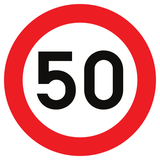
No. It is a reference indication and does not replace a C43 speed sign, speed zone or general speed rule.

🔗 codex.vlaanderen.be • Belgian Road Code — articles 10–11, 21.4 and 71; road-location references are not speed/access permissions

🔗 wegcode.be • Road Code of 1 December 1975 — 10–11, 21.4 and 71; road-location references are not speed/access permissions

🔗 wegenenverkeer.be • AWV — road number and kilometre point on hectometre posts

🔗 geoportail.wallonie.be • SPW — Bornes routières et autoroutières, updated 7 October 2026

Start of a speed limit. Start of a speed limit.

English • Traffic sign C43 • Travelling faster than the indicated speed is prohibited from the sign up to and including the next junction, or until any C43 sign, with or without zonal validity, or a sign marking the beginning or end of a built-up area, residential area (zone résidentielle or zone de rencontre), or pedestrian zone.

Français • Signal routier C43 • A partir du signal jusqu'au prochain carrefour inclus, ou jusqu’à chaque signal C43 avec ou sans validité zonale, ou jusqu’au signal indiquant le début ou la fin d’une agglomération, d’une zone résidentielle, d’une zone de rencontre ou d’une zone piétonne, interdiction de circuler à une vitesse supérieure à celle qui est indiquée.

Nederlands • Verkeersbord C43 • Vanaf het verkeersbord tot en met het volgend kruispunt, of tot elk verkeersbord C43 met of zonder zonale geldigheid, of tot het verkeersbord dat het begin of het einde van een bebouwde kom, van een woonerf of erf, of van een voetgangerszone aanduidt, verbod te rijden met een grotere snelheid dan deze die is aangeduid.

1 Brussels 2 Motorway 3 Expressway 4 Residential area 5 Built-up area 6 Zone 7 Speed limit 8 Bike path 9 Cycling street 10 Pedestrian zone 11 Speed bump 12 Customs 13 One-way traffic 14 Quay 15 Slope 16 Bus lane 17 Dead end 18 Stop sign 19 Give way 20 Roundabout 21 Priority road 22 Road narrowing 23 Priority over oncoming traffic 24 Give way to oncoming traffic 25 Pedestrian crossing 26 Railway crossing 27 Mandatory direction 28 Turn prohibition 29 School area 30 Crossing animals 31 Rockfall 32 Curve 33 Chevron 34 Wrong-way driving 35 Roadworks 36 Height limit 37 Width limit 38 Weight limit 39 Radar speed sign 40 Selective barriers 41 Intersection direction sign 42 Priority at the next junction 43 Traffic lights 44 Pedestrian lights 45 Driving licence 46 Location marker 47 Traffic mirror 48 International border 49 Cycling route 50 Parking 51 No parking 52 Kiss and ride 53 Parking meter 54 Traffic management 55 Reversing 56 Uncontrolled crossroad 57 Road surface 58 Ring road 59 Cycle highway 60 Licence plate 61 Charging station 62 Dangers 63 Turn on red 64 Identity card 65 Fire risk 66 Pedestrian 67 Moped 68 Car 69 Truck 70 Bus 71 Police 72 Ambulance 73 Tram lights 74 European emission standard 75 Pothole 76 Public square 77 Path 78 Particulates 79 Air pollution 80 Rush hour 81 Road code 82 Street gutter 83 Cargo bike 84 Forestry vehicle 85 Construction vehicle 86 Semi-trailer truck 87 Trolleybus 88 Speed pedelec 89 Delivery vehicle 90 Idling 91 Tow truck 92 Four-wheel drive 93 No vehicles 94 Bicycle 95 Motorcycle equipment 96 Railcar 97 Rail track 98 Public transport 99 Caravan 100 Trailer ...