
Road numberFrance

An introduction to the traffic rules and road signs of France. Learn about driving, road safety and much more in our illustrated book, with answers to frequently asked questions.

For informational purposes only. Always follow official regulations. Some content and images were created with AI assistance.


64. Road number

A road number is a number or combination of letters and numbers used to identify a particular road or route within a road network. Road numbers help drivers follow routes, distinguish between different types of roads and navigate between cities, regions and countries.

Road numbers are commonly displayed on route markers and direction signs. Their format, colour and prefixes vary between countries and may indicate whether a route is a motorway, national road, regional road or international route.
Road number
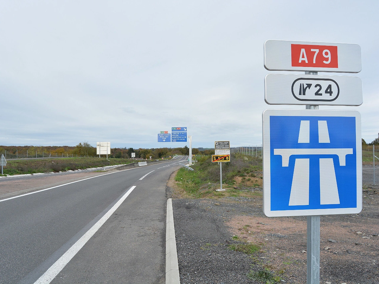
Signs with motorway number A79 and exit number 24. (Auvergne-Rhône-Alpes, France)
Wikimedia.org • Tabl-trai • CC BY-SA
How are road or route numbers identified in France?

Common examples include A motorways, N national roads and D departmental roads. Follow the route shield and destination signs, because some routes share a section of road or change designation at a border.

🔗 equipementsdelaroute.cerema.fr • French IISR part5, indications and services, September2025 consolidation — IISR5 Article99-4 E40 A/N/D route identification and direction-guidance provisions; route identifier distinct from statutory or signed limit.

🔗 equipementsdelaroute.cerema.fr • French road-sign order, Article 5-8, signs EB10 and EB20

🔗 service-public.gouv.fr • French Government, national and built-up-area speed limits
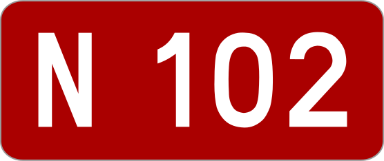
Ordinary road number. Ordinary road number.

English • Traffic sign E42 • Red route number panel identifying roads and motorways in the national network. Example shown: N 102, a national road; this is not a motorway number.

Français • Panneau E42 • Cartouche à fond rouge caractérisant les routes et autoroutes du réseau national. Exemple représenté : N 102, une route nationale ; ce n’est pas un numéro d’autoroute.

Sources

🔗 Commons.wikimedia.org
🔗 Legifrance.gouv.fr • Arrêté du 24 novembre 1967 • article 5-7 Source : Roulex 45 • Domaine public • SVG original non modifié.

Image via Commons.wikimedia.org
Roulex 45 • Public domain • Source revision 2014-05-05. Wikimedia original unmodified.

Does a route number by itself establish a speed limit in France?

No. A route number is an identification and navigation reference. Legal speed limits and other restrictions come from the applicable road category, vehicle rules and regulatory signs; the same route number may include sections with different limits.

🔗 equipementsdelaroute.cerema.fr • French IISR part5, indications and services, September2025 consolidation — IISR5 Article99-4 E40 A/N/D route identification and direction-guidance provisions; route identifier distinct from statutory or signed limit.

🔗 equipementsdelaroute.cerema.fr • French road-sign order, Article 5-8, signs EB10 and EB20

🔗 service-public.gouv.fr • French Government, national and built-up-area speed limits

What should you check when following a numbered route in France?

Check the route number, destination, direction and junction or exit signs. If the route shares the road with another number or continues onto a different road class, follow the signs rather than relying solely on a navigation app.

🔗 equipementsdelaroute.cerema.fr • French IISR part5, indications and services, September2025 consolidation — IISR5 Article99-4 E40 A/N/D route identification and direction-guidance provisions; route identifier distinct from statutory or signed limit.

🔗 equipementsdelaroute.cerema.fr • French road-sign order, Article 5-8, signs EB10 and EB20

🔗 service-public.gouv.fr • French Government, national and built-up-area speed limits

1 France 2 Motorway 3 Expressway 4 Residential area 5 Zone 6 Speed limit 7 Minimum speed 8 Advisory speed 9 Footpath 10 Bike path 11 Pedestrian warning 12 Tunnel 13 Bridge 14 Cycling street 15 Pedestrian zone 16 Speed bump 17 Toll road 18 Customs 19 One-way traffic 20 Quay 21 Slope 22 Bus lane 23 Bus stop 24 Dead end 25 Stop sign 26 Give way 27 Roundabout 28 Priority road 29 Road narrowing 30 Priority over oncoming traffic 31 Give way to oncoming traffic 32 Pedestrian crossing 33 Railway crossing 34 Mandatory direction 35 Turn prohibition 36 School area 37 Overtaking 38 Crossing animals 39 Slippery road 40 Rockfall 41 Aircraft 42 Curve 43 Chevron 44 Wrong-way driving 45 Roadworks 46 Crosswind 47 Height limit 48 Width limit 49 Length limit 50 Weight limit 51 Radar speed sign 52 Selective barriers 53 Low-emission zone 54 Priority at the next junction 55 Traffic lights 56 Traffic lights warning 57 Pedestrian lights 58 Road markings 59 Junction layout 60 Bike box 61 Speed feedback 62 Driving licence 63 Location marker 64 Road number 65 Countdown markers 66 Public toilet 67 Rest area 68 Traffic mirror 69 Emergency telephone 70 International border 71 Cycling route 72 End of restriction 73 Parking 74 No parking 75 No stopping 76 Parallel parking 77 Alternate-side parking 78 Parking meter 79 Parking disc 80 Disabled parking 81 Traffic management 82 Merging 83 Reversing 84 U-turn 85 Carpool 86 Traffic jam 87 Uncontrolled crossroad 88 Road surface 89 Ring road 90 Exit 91 Information point 92 Horse riding 93 Provisional licence 94 Hazardous cargo 95 Emergency exit 96 Runaway truck ramp 97 Radio service 98 Oversize load 99 Lane 100 Tyre inflation station ...